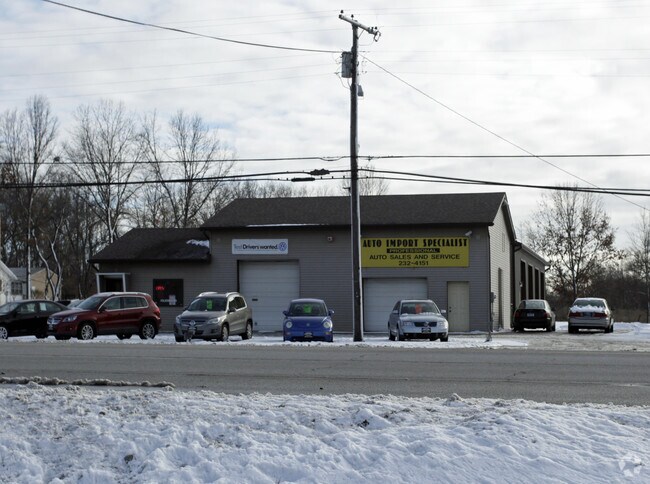
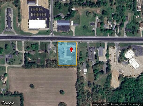
Property Record
25292 State Road 2, South Bend, IN 46619

NEARBY LISTINGS FOR SALE OR LEASE
-
-
View all South Bend listings for sale on LoopNet.com
Property Detail
25292 State Road 2
South Bend-Mishawaka, IN-MI
Schroeders Sub
71-07-12-403-004.000-029
LOTS 4 & 5 SCHROEDERS SUB SEC 12-37-1E
Storebuilding
St Joseph
X
Indiana
18141C0190D
4,5
2023
1.55 AC
2024
Outlying St Joseph County
010901
South Bend/Mishawaka
5,496 SF
DEMOGRAPHICS near 25292 State Road 2
1 Mile
3 Mile
5 Mile
2024 Total Population
1,558
17,570
53,760
2029 Population
1,532
17,374
53,906
Pop Growth 2024-2029
(1.67%)
(1.12%)
+ 0.27%
Average Age
46
40
37
2024 Total Households
657
6,698
19,938
HH Growth 2024-2029
(1.67%)
(1.21%)
+ 0.11%
Median Household Inc
$62,582
$50,192
$43,412
Avg Household Size
2.30
2.50
2.60
2024 Avg HH Vehicles
2.00
2.00
2.00
Median Home Value
$161,246
$120,534
$101,204
Median Year Built
1972
1958
1956
Nearby Places
Map Layers
Map Styles
 Street
 Aerial
- Restaurants
- Banks
- Shops
- Fitness
- Groceries
PUBLIC TRANSPORTATION
COMMUTER RAIL
South Bend Amtrak Station (Capitol Limited - Amtrak, Lake Shore Limited - Amtrak)
DRIVE
WALK
Distance
South Bend Amtrak Station (Capitol Limited - Amtrak, Lake Shore Limited - Amtrak)
8 min
4.2 mi
South Bend Airport Station (South Shore Line - Northern Indiana Commuter Transportation District (South Shore Line))
DRIVE
WALK
Distance
South Bend Airport Station (South Shore Line - Northern Indiana Commuter Transportation District (South Shore Line))
9 min
4.5 mi
AIRPORT
South Bend International
DRIVE
WALK
Distance
South Bend International
16 min
5.4 mi
Freight Ports
Port Milwaukee
DRIVE
WALK
Distance
Port Milwaukee
211 min
170.1 mi
Nearby Properties
Address
Land Use
TOTAL SIZE
Lot Size
Zoning
Address
Land Use
TOTAL SIZE
Lot Size
Zoning
165,725 SF
0.01 AC
Address
Land Use
TOTAL SIZE
Lot Size
Zoning
92,456 SF
44 SF
Address
Land Use
TOTAL SIZE
Lot Size
Zoning
45,191 SF
44 SF
Address
Land Use
TOTAL SIZE
Lot Size
Zoning
150,280 SF
21 AC
Address
Land Use
TOTAL SIZE
Lot Size
Zoning
92,478 SF
5.10 AC
Address
Land Use
TOTAL SIZE
Lot Size
Zoning
95,436 SF
44 SF
Address
Land Use
TOTAL SIZE
Lot Size
Zoning
93,477 SF
15.53 AC
Address
Land Use
TOTAL SIZE
Lot Size
Zoning
317,436 SF
9.18 AC
Address
Land Use
TOTAL SIZE
Lot Size
Zoning
233,224 SF
6.09 AC
Address
Land Use
TOTAL SIZE
Lot Size
Zoning
49,680 SF
44 SF
Address
Land Use
TOTAL SIZE
Lot Size
Zoning
304,652 SF
18.25 AC
Address
Land Use
TOTAL SIZE
Lot Size
Zoning
110,604 SF
17.02 AC
Address
Land Use
TOTAL SIZE
Lot Size
Zoning
84,252 SF
8.95 AC
Address
Land Use
TOTAL SIZE
Lot Size
Zoning
42,748 SF
35 AC
Address
Land Use
TOTAL SIZE
Lot Size
Zoning
26,016 SF
62 AC
Address
Land Use
TOTAL SIZE
Lot Size
Zoning
45,238 SF
0.02 AC
Address
Land Use
TOTAL SIZE
Lot Size
Zoning
35,040 SF
2.36 AC
Address
Land Use
TOTAL SIZE
Lot Size
Zoning
95,628 SF
10.74 AC
Address
Land Use
TOTAL SIZE
Lot Size
Zoning
64,139 SF
44 SF
Address
Land Use
TOTAL SIZE
Lot Size
Zoning
70,949 SF
4.41 AC
Address
Land Use
TOTAL SIZE
Lot Size
Zoning
40,600 SF
7.40 AC
Address
Land Use
TOTAL SIZE
Lot Size
Zoning
55,512 SF
9.27 AC
Address
Land Use
TOTAL SIZE
Lot Size
Zoning
56,752 SF
2.79 AC
Address
Land Use
TOTAL SIZE
Lot Size
Zoning
24,130 SF
44 SF
Address
Land Use
TOTAL SIZE
Lot Size
Zoning
41,950 SF
2.33 AC
Address
Land Use
TOTAL SIZE
Lot Size
Zoning
64,880 SF
30 AC
Address
Land Use
TOTAL SIZE
Lot Size
Zoning
70,722 SF
Address
Land Use
TOTAL SIZE
Lot Size
Zoning
13,508 SF
1.07 AC
Address
Land Use
TOTAL SIZE
Lot Size
Zoning
3,920 SF
14.10 AC
Address
Land Use
TOTAL SIZE
Lot Size
Zoning
118,857 SF
15 AC
The World's #1 Commercial Real Estate Marketplace
Connect with us
© 2025 CoStar Group
The information above has been obtained from sources believed reliable. While we do not doubt its accuracy we have not verified it and make no guarantee, warranty or representation about it. It is your responsibility to independently confirm its accuracy and completeness. Any projections, opinions, assumptions, or estimates used are for example only and do not represent the current or future performance of the property. The value of this transaction to you depends on tax and other factors which should be evaluated by your tax, financial, and legal advisors. You and your advisors should conduct a careful, independent investigation of the property to determine to your satisfaction the suitability of the property for your needs.