Property Record
253 Mansfield Ave, Norton, MA 02766


NEARBY LISTINGS FOR SALE OR LEASE
Property Detail
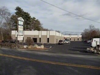
253 Mansfield Ave
Warehouse
Bristol
X
Massachusetts
25005C0127F
2.40 AC
2025
Attleboro/New Bedford
2025
Boston
611202
Providence-Warwick, RI-MA
27,760 SF
NORT-000003-000000-000722
DEMOGRAPHICS near 253 Mansfield Ave
1 Mile
3 Mile
5 Mile
2024 Total Population
2,231
27,519
75,429
2029 Population
2,226
27,364
75,177
Pop Growth 2024-2029
(0.22%)
(0.56%)
(0.33%)
Average Age
47
41
41
2024 Total Households
954
10,115
27,949
HH Growth 2024-2029
(0.21%)
(0.45%)
(0.32%)
Median Household Inc
$93,816
$113,112
$114,638
Avg Household Size
2.30
2.50
2.60
2024 Avg HH Vehicles
2.00
2.00
2.00
Median Home Value
$370,489
$475,453
$482,662
Median Year Built
1980
1979
1979
Nearby Places
Map Layers
Map Styles
 Street
 Aerial
- Restaurants
- Banks
- Shops
- Fitness
- Groceries
PUBLIC TRANSPORTATION
COMMUTER RAIL
Mansfield (Foxboro Line (Special Events Only) - Massachusetts Bay Transportation Authority Commuter Rail (Purple Line), Providence/Stoughton Line - Massachusetts Bay Transportation Authority Commuter Rail (Purple Line))
DRIVE
WALK
Distance
Mansfield (Foxboro Line (Special Events Only) - Massachusetts Bay Transportation Authority Commuter Rail (Purple Line), Providence/Stoughton Line - Massachusetts Bay Transportation Authority Commuter Rail (Purple Line))
10 min
3.6 mi
Attleboro (Providence/Stoughton Line - Massachusetts Bay Transportation Authority Commuter Rail (Purple Line))
DRIVE
WALK
Distance
Attleboro (Providence/Stoughton Line - Massachusetts Bay Transportation Authority Commuter Rail (Purple Line))
13 min
8.1 mi
AIRPORT
Rhode Island Tf Green International
DRIVE
WALK
Distance
Rhode Island Tf Green International
47 min
30.4 mi
General Edward Lawrence Logan International
DRIVE
WALK
Distance
General Edward Lawrence Logan International
53 min
36.8 mi
Worcester Regional
DRIVE
WALK
Distance
Worcester Regional
68 min
47.9 mi
Freight Ports
Port of Boston
DRIVE
WALK
Distance
Port of Boston
50 min
31.4 mi
SALE & LEASE HISTORY
LISTING DATE
SALE/LEASE

Sep 23, 2016
For Sale
Nov 22, 2016
For Lease
Mar 09, 2020
For Lease
Jan 06, 2025
For Lease
Nearby Properties
Address
Land Use
TOTAL SIZE
Lot Size
Zoning
Address
Land Use
TOTAL SIZE
Lot Size
Zoning
Address
Land Use
TOTAL SIZE
Lot Size
Zoning
Address
Land Use
TOTAL SIZE
Lot Size
Zoning
351,950 SF
31.45 AC
Address
Land Use
TOTAL SIZE
Lot Size
Zoning
3,838 SF
1.11 AC
R80
Address
Land Use
TOTAL SIZE
Lot Size
Zoning
223,480 SF
37.59 AC
Address
Land Use
TOTAL SIZE
Lot Size
Zoning
Address
Land Use
TOTAL SIZE
Lot Size
Zoning
177,218 SF
50.82 AC
Address
Land Use
TOTAL SIZE
Lot Size
Zoning
Address
Land Use
TOTAL SIZE
Lot Size
Zoning
350,067 SF
20.20 AC
Address
Land Use
TOTAL SIZE
Lot Size
Zoning
442,756 SF
31.18 AC
Address
Land Use
TOTAL SIZE
Lot Size
Zoning
113,788 SF
1.67 AC
Address
Land Use
TOTAL SIZE
Lot Size
Zoning
33.31 AC
Address
Land Use
TOTAL SIZE
Lot Size
Zoning
3,330 SF
1.37 AC
Address
Land Use
TOTAL SIZE
Lot Size
Zoning
123,740 SF
10.67 AC
R80
Address
Land Use
TOTAL SIZE
Lot Size
Zoning
205,400 SF
10 AC
Address
Land Use
TOTAL SIZE
Lot Size
Zoning
24.50 AC
Address
Land Use
TOTAL SIZE
Lot Size
Zoning
26.70 AC
Address
Land Use
TOTAL SIZE
Lot Size
Zoning
82,828 SF
15.45 AC
Address
Land Use
TOTAL SIZE
Lot Size
Zoning
230,394 SF
19.77 AC
Address
Land Use
TOTAL SIZE
Lot Size
Zoning
186,200 SF
20.27 AC
Address
Land Use
TOTAL SIZE
Lot Size
Zoning
82,946 SF
25.50 AC
Address
Land Use
TOTAL SIZE
Lot Size
Zoning
358.70 AC
Address
Land Use
TOTAL SIZE
Lot Size
Zoning
164,823 SF
9.61 AC
Address
Land Use
TOTAL SIZE
Lot Size
Zoning
203,520 SF
13.50 AC
Address
Land Use
TOTAL SIZE
Lot Size
Zoning
201,232 SF
11.10 AC
Address
Land Use
TOTAL SIZE
Lot Size
Zoning
177,186 SF
20.46 AC
Address
Land Use
TOTAL SIZE
Lot Size
Zoning
6.30 AC
Address
Land Use
TOTAL SIZE
Lot Size
Zoning
80,286 SF
8.70 AC
Address
Land Use
TOTAL SIZE
Lot Size
Zoning
57.90 AC
Address
Land Use
TOTAL SIZE
Lot Size
Zoning
106.27 AC
The World's #1 Commercial Real Estate Marketplace
Connect with us
© 2026 CoStar Group
The information above has been obtained from sources believed reliable. While we do not doubt its accuracy we have not verified it and make no guarantee, warranty or representation about it. It is your responsibility to independently confirm its accuracy and completeness. Any projections, opinions, assumptions, or estimates used are for example only and do not represent the current or future performance of the property. The value of this transaction to you depends on tax and other factors which should be evaluated by your tax, financial, and legal advisors. You and your advisors should conduct a careful, independent investigation of the property to determine to your satisfaction the suitability of the property for your needs.