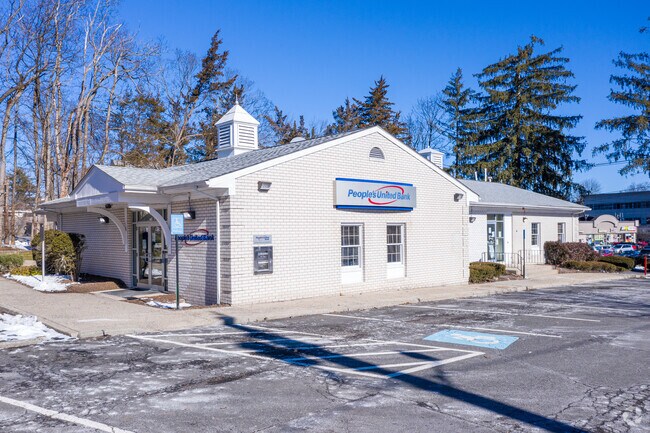
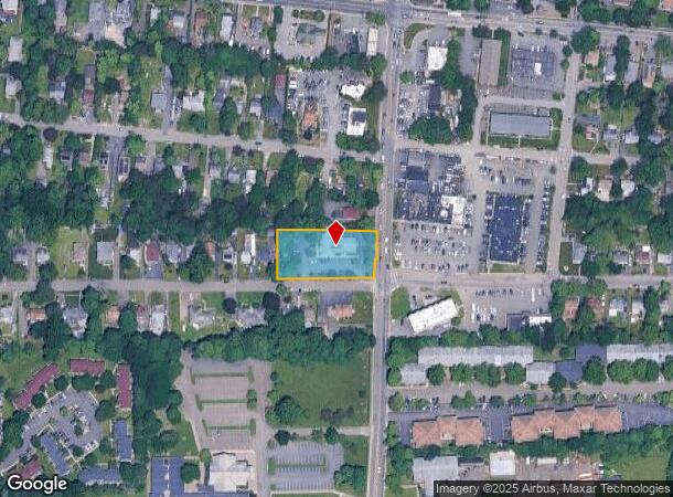
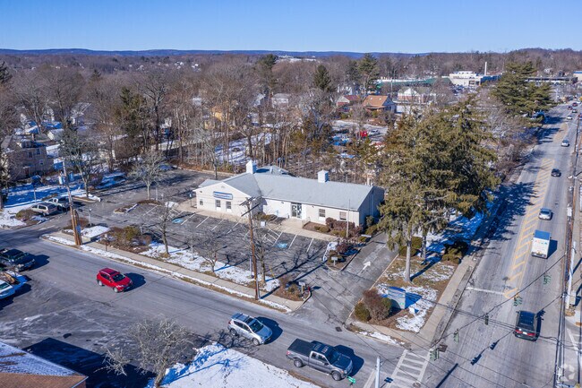
Property Record
253 N Main St N, Spring Valley, NY 10977

NEARBY LISTINGS FOR SALE OR LEASE
Property Detail
253 N Main St N
392689-050-014-0004-065-000-0000
Alfred G Eckerson Map 02
Financialbuilding
Rockland
X
New York
36087C0093G
65.0
2023
0.78 AC
2024
Ramapo
011511
Northern New Jersey
7,236 SF
New York-Jersey City-White Plains, NY-NJ
DEMOGRAPHICS near 253 N Main St N
1 Mile
3 Mile
5 Mile
2024 Total Population
36,102
145,130
232,317
2029 Population
35,917
144,089
231,463
Pop Growth 2024-2029
(0.51%)
(0.72%)
(0.37%)
Average Age
31
32
35
2024 Total Households
8,625
36,714
65,678
HH Growth 2024-2029
(0.53%)
(0.74%)
(0.33%)
Median Household Inc
$63,701
$82,445
$99,569
Avg Household Size
3.90
3.70
3.30
2024 Avg HH Vehicles
2.00
2.00
2.00
Median Home Value
$463,131
$586,597
$598,636
Median Year Built
1974
1974
1972
Nearby Places
- Restaurants
- Banks
- Shops
- Fitness
- Groceries
PUBLIC TRANSPORTATION
TRANSIT/SUBWAY
Spring Valley (Pascack Valley Line - NJ Transit Commuter Rail (NJ Transit))
DRIVE
WALK
Distance
Spring Valley (Pascack Valley Line - NJ Transit Commuter Rail (NJ Transit))
3 min
20 min
1.1 mi
COMMUTER RAIL
Spring Valley (Pascack Valley Line - NJ Transit Commuter Rail (NJ Transit))
DRIVE
WALK
Distance
Spring Valley (Pascack Valley Line - NJ Transit Commuter Rail (NJ Transit))
3 min
20 min
1.1 mi
Nanuet (Pascack Valley Line - NJ Transit Commuter Rail (NJ Transit))
DRIVE
WALK
Distance
Nanuet (Pascack Valley Line - NJ Transit Commuter Rail (NJ Transit))
7 min
3.7 mi
AIRPORT
Westchester County
DRIVE
WALK
Distance
Westchester County
38 min
25.9 mi
LaGuardia
DRIVE
WALK
Distance
LaGuardia
53 min
35.3 mi
New York Stewart International
DRIVE
WALK
Distance
New York Stewart International
54 min
36.0 mi
Freight Ports
Maher Terminal
DRIVE
WALK
Distance
Maher Terminal
54 min
38.2 mi
Nearby Properties
Address
Land Use
TOTAL SIZE
Lot Size
Zoning
Address
Land Use
TOTAL SIZE
Lot Size
Zoning
402,385 SF
23.10 AC
LI
Address
Land Use
TOTAL SIZE
Lot Size
Zoning
146,101 SF
55 AC
Address
Land Use
TOTAL SIZE
Lot Size
Zoning
37,600 SF
31.41 AC
Address
Land Use
TOTAL SIZE
Lot Size
Zoning
609,540 SF
174.09 AC
R-50
Address
Land Use
TOTAL SIZE
Lot Size
Zoning
116,650 SF
39.20 AC
05
Address
Land Use
TOTAL SIZE
Lot Size
Zoning
104,303 SF
71.26 AC
RR-50
Address
Land Use
TOTAL SIZE
Lot Size
Zoning
152,854 SF
18.75 AC
RS
Address
Land Use
TOTAL SIZE
Lot Size
Zoning
270,962 SF
21.80 AC
CS
Address
Land Use
TOTAL SIZE
Lot Size
Zoning
2,220 SF
15.10 AC
02 - SINGL
Address
Land Use
TOTAL SIZE
Lot Size
Zoning
129,957 SF
21.90 AC
Address
Land Use
TOTAL SIZE
Lot Size
Zoning
95,890 SF
60 AC
Address
Land Use
TOTAL SIZE
Lot Size
Zoning
70,527 SF
10.20 AC
RSH
Address
Land Use
TOTAL SIZE
Lot Size
Zoning
117,950 SF
11.13 AC
05
Address
Land Use
TOTAL SIZE
Lot Size
Zoning
141,846 SF
12.81 AC
05
Address
Land Use
TOTAL SIZE
Lot Size
Zoning
275,724 SF
40 AC
R1
Address
Land Use
TOTAL SIZE
Lot Size
Zoning
4,492 SF
14.50 AC
Address
Land Use
TOTAL SIZE
Lot Size
Zoning
64,024 SF
7.30 AC
Address
Land Use
TOTAL SIZE
Lot Size
Zoning
101,628 SF
9.23 AC
05
Address
Land Use
TOTAL SIZE
Lot Size
Zoning
38,056 SF
21.21 AC
R-15C
Address
Land Use
TOTAL SIZE
Lot Size
Zoning
78,895 SF
18.20 AC
Address
Land Use
TOTAL SIZE
Lot Size
Zoning
1,547 SF
6.60 AC
Address
Land Use
TOTAL SIZE
Lot Size
Zoning
125,097 SF
4.60 AC
05
Address
Land Use
TOTAL SIZE
Lot Size
Zoning
82,307 SF
4.30 AC
LI
Address
Land Use
TOTAL SIZE
Lot Size
Zoning
60,803 SF
6.70 AC
02 - SINGL
Address
Land Use
TOTAL SIZE
Lot Size
Zoning
106,960 SF
8.04 AC
CS
Address
Land Use
TOTAL SIZE
Lot Size
Zoning
121,674 SF
11.53 AC
Address
Land Use
TOTAL SIZE
Lot Size
Zoning
1,656 SF
20 AC
02 - SINGL
Address
Land Use
TOTAL SIZE
Lot Size
Zoning
243,977 SF
27.29 AC
R40
Address
Land Use
TOTAL SIZE
Lot Size
Zoning
148,712 SF
34.01 AC
PLI
Address
Land Use
TOTAL SIZE
Lot Size
Zoning
66,669 SF
1.71 AC
The World's #1 Commercial Real Estate Marketplace
Connect with us
© 2025 CoStar Group
The information above has been obtained from sources believed reliable. While we do not doubt its accuracy we have not verified it and make no guarantee, warranty or representation about it. It is your responsibility to independently confirm its accuracy and completeness. Any projections, opinions, assumptions, or estimates used are for example only and do not represent the current or future performance of the property. The value of this transaction to you depends on tax and other factors which should be evaluated by your tax, financial, and legal advisors. You and your advisors should conduct a careful, independent investigation of the property to determine to your satisfaction the suitability of the property for your needs.