Property Record
253 Rockingham Rd, Derry, NH 03038

Property Detail
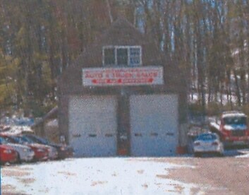
253 Rockingham Rd
Autorepair
Rockingham
GC4
New Hampshire
B and X Area of moderate flood hazard, usually the area between the limits of the 100-year and 500-year floods.
2.62 AC
2025
Rockingham
2025
Boston
003601
Boston-Cambridge-Newton, MA-NH
5,688 SF
DERY-000003-000000-000034
NEARBY LISTINGS FOR SALE OR LEASE
-
-
View all Derry listings for sale on LoopNet.com
DEMOGRAPHICS near 253 Rockingham Rd
1 mile
3 mile
5 mile
2025 Total Population
1,858
19,016
65,726
2030 Population
1,866
19,048
66,251
Pop Growth 2025-2030
+ 0.43%
+ 0.17%
+ 0.80%
Average Age
42
42
43
2025 Total Households
639
6,799
25,001
HH Growth 2025-2030
+ 0.16%
(0.04%)
+ 0.67%
Median Household Inc
$163,129
$138,153
$116,436
Avg Household Size
2.80
2.70
2.60
2025 Avg HH Vehicles
3.00
2.00
2.00
Median Home Value
$590,909
$542,631
$503,349
Median Year Built
1986
1984
1981
Nearby Places
Map Layers
Map Styles
 Street
 Aerial
Layers
 Traffic
 Biking
Places
Listings with unknown addresses are not visible on the map
- Restaurants
- Banks
- Shops
- Fitness
- Groceries
PUBLIC TRANSPORTATION
AIRPORT
Manchester Boston Regional
Drive
Walk
Distance
Manchester Boston Regional
32 min
13.7 mi
Portsmouth International at Pease
Drive
Walk
Distance
Portsmouth International at Pease
63 min
42.8 mi
Freight Ports
Port of Boston
Drive
Walk
Distance
Port of Boston
56 min
40.0 mi
Nearby Properties
Address
Land Use
TOTAL SIZE
Lot Size
Zoning
Address
Land Use
TOTAL SIZE
Lot Size
Zoning
21,433 SF
7.54 AC
LID
Address
Land Use
TOTAL SIZE
Lot Size
Zoning
58,449 SF
41.20 AC
RD
Address
Land Use
TOTAL SIZE
Lot Size
Zoning
20,784 SF
15 AC
PBT
Address
Land Use
TOTAL SIZE
Lot Size
Zoning
4.10 AC
MFR
Address
Land Use
TOTAL SIZE
Lot Size
Zoning
4.14 AC
MFR
Address
Land Use
TOTAL SIZE
Lot Size
Zoning
51,881 SF
12.01 AC
MDR
Address
Land Use
TOTAL SIZE
Lot Size
Zoning
3,556 SF
7.45 AC
RD
Address
Land Use
TOTAL SIZE
Lot Size
Zoning
56,632 SF
14.20 AC
RUR
Address
Land Use
TOTAL SIZE
Lot Size
Zoning
26,262 SF
3.75 AC
CDA
Address
Land Use
TOTAL SIZE
Lot Size
Zoning
7,280 SF
1.88 AC
GCD
Address
Land Use
TOTAL SIZE
Lot Size
Zoning
25,200 SF
3.52 AC
CDA
Address
Land Use
TOTAL SIZE
Lot Size
Zoning
7.21 AC
IND5
Address
Land Use
TOTAL SIZE
Lot Size
Zoning
31,896 SF
2.50 AC
MFR
Address
Land Use
TOTAL SIZE
Lot Size
Zoning
23,544 SF
14.45 AC
CDB
Address
Land Use
TOTAL SIZE
Lot Size
Zoning
42,720 SF
5.27 AC
LID
Address
Land Use
TOTAL SIZE
Lot Size
Zoning
40,000 SF
7.53 AC
CDA
Address
Land Use
TOTAL SIZE
Lot Size
Zoning
23,964 SF
12.47 AC
MZ
Address
Land Use
TOTAL SIZE
Lot Size
Zoning
31,096 SF
14.47 AC
CDA
Address
Land Use
TOTAL SIZE
Lot Size
Zoning
46,020 SF
3.46 AC
CDA
Address
Land Use
TOTAL SIZE
Lot Size
Zoning
25,512 SF
2.50 AC
MFR
Address
Land Use
TOTAL SIZE
Lot Size
Zoning
25,512 SF
2.11 AC
MFR
Address
Land Use
TOTAL SIZE
Lot Size
Zoning
21,600 SF
1.70 AC
MHDR
Address
Land Use
TOTAL SIZE
Lot Size
Zoning
19,448 SF
4.59 AC
CDA
Address
Land Use
TOTAL SIZE
Lot Size
Zoning
10,752 SF
30.65 AC
MZ
Address
Land Use
TOTAL SIZE
Lot Size
Zoning
3,616 SF
17.77 AC
GC4
Address
Land Use
TOTAL SIZE
Lot Size
Zoning
19,368 SF
7.77 AC
RD
Address
Land Use
TOTAL SIZE
Lot Size
Zoning
11,316 SF
1.47 AC
GCD
Address
Land Use
TOTAL SIZE
Lot Size
Zoning
18,164 SF
1.52 AC
CDA
Address
Land Use
TOTAL SIZE
Lot Size
Zoning
14,540 SF
2.28 AC
OMB
Address
Land Use
TOTAL SIZE
Lot Size
Zoning
30.36 AC
GC
The World's #1 Commercial Real Estate Marketplace
Connect with us
© 2026 CoStar Group
The information above has been obtained from sources believed reliable. While we do not doubt its accuracy we have not verified it and make no guarantee, warranty or representation about it. It is your responsibility to independently confirm its accuracy and completeness. Any projections, opinions, assumptions, or estimates used are for example only and do not represent the current or future performance of the property. The value of this transaction to you depends on tax and other factors which should be evaluated by your tax, financial, and legal advisors. You and your advisors should conduct a careful, independent investigation of the property to determine to your satisfaction the suitability of the property for your needs.