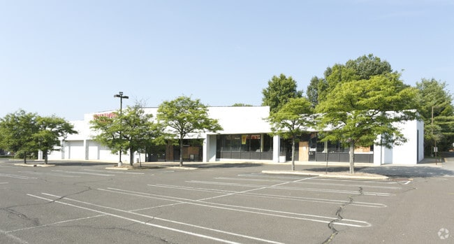
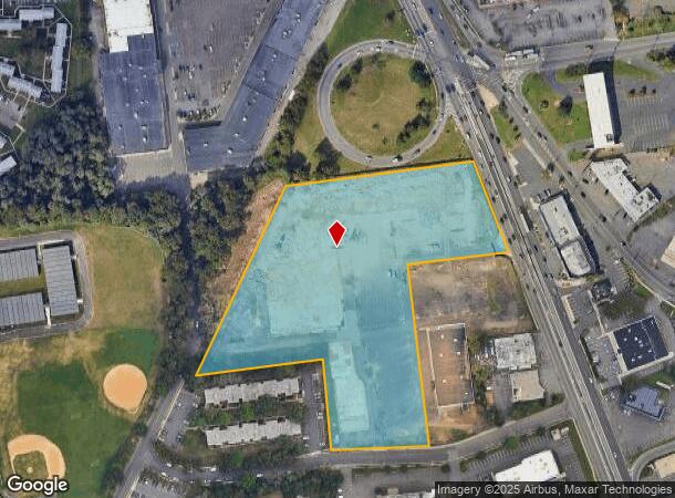
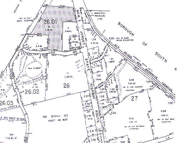
Property Record
253 State Route 18, East Brunswick, NJ 08816
NEARBY LISTINGS FOR SALE OR LEASE
Property Detail
253 State Route 18
04-00026-01-00012
7.88
Regionalshoppingcenterormallwithanchorstore
Middlesex
X
New Jersey
34023C0134F
12
2024
7.88 AC
2025
Brunswick
009400
Northern New Jersey
85,302 SF
New York-Jersey City-White Plains, NY-NJ
DEMOGRAPHICS near 253 State Route 18
1 Mile
3 Mile
5 Mile
2024 Total Population
8,460
105,760
268,814
2029 Population
8,498
105,085
267,041
Pop Growth 2024-2029
+ 0.45%
(0.64%)
(0.66%)
Average Age
40
39
38
2024 Total Households
3,296
36,808
90,559
HH Growth 2024-2029
+ 0.55%
(0.46%)
(0.59%)
Median Household Inc
$101,458
$88,131
$92,792
Avg Household Size
2.50
2.70
2.80
2024 Avg HH Vehicles
2.00
2.00
2.00
Median Home Value
$437,053
$385,405
$388,442
Median Year Built
1974
1964
1969
Nearby Places
Map Layers
Map Styles
 Street
 Aerial
- Restaurants
- Banks
- Shops
- Fitness
- Groceries
PUBLIC TRANSPORTATION
COMMUTER RAIL
New Brunswick (Northeast Corridor Line - NJ Transit Commuter Rail (NJ Transit))
DRIVE
WALK
Distance
New Brunswick (Northeast Corridor Line - NJ Transit Commuter Rail (NJ Transit))
10 min
5.5 mi
Jersey Avenue (Northeast Corridor Line - NJ Transit Commuter Rail (NJ Transit))
DRIVE
WALK
Distance
Jersey Avenue (Northeast Corridor Line - NJ Transit Commuter Rail (NJ Transit))
18 min
7.5 mi
AIRPORT
Newark Liberty International
DRIVE
WALK
Distance
Newark Liberty International
38 min
27.5 mi
Trenton Mercer
DRIVE
WALK
Distance
Trenton Mercer
46 min
31.9 mi
Freight Ports
New York Container Terminal
DRIVE
WALK
Distance
New York Container Terminal
31 min
22.7 mi
Nearby Properties
Address
Land Use
TOTAL SIZE
Lot Size
Zoning
Address
Land Use
TOTAL SIZE
Lot Size
Zoning
38,536 SF
149.61 AC
IN-2
Address
Land Use
TOTAL SIZE
Lot Size
Zoning
37.80 AC
IN-2
Address
Land Use
TOTAL SIZE
Lot Size
Zoning
77.04 AC
I2
Address
Land Use
TOTAL SIZE
Lot Size
Zoning
Address
Land Use
TOTAL SIZE
Lot Size
Zoning
1.15 AC
C-4
Address
Land Use
TOTAL SIZE
Lot Size
Zoning
5.54 AC
C-5
Address
Land Use
TOTAL SIZE
Lot Size
Zoning
Address
Land Use
TOTAL SIZE
Lot Size
Zoning
Address
Land Use
TOTAL SIZE
Lot Size
Zoning
81,600 SF
49.89 AC
LI
Address
Land Use
TOTAL SIZE
Lot Size
Zoning
4,600 SF
33.13 AC
IN-2
Address
Land Use
TOTAL SIZE
Lot Size
Zoning
182.24 AC
ERR
Address
Land Use
TOTAL SIZE
Lot Size
Zoning
26,965 SF
2.70 AC
C-3A
Address
Land Use
TOTAL SIZE
Lot Size
Zoning
12,800 SF
17.08 AC
R-6
Address
Land Use
TOTAL SIZE
Lot Size
Zoning
11.21 AC
.
Address
Land Use
TOTAL SIZE
Lot Size
Zoning
27.88 AC
C2
Address
Land Use
TOTAL SIZE
Lot Size
Zoning
1.31 AC
C-4
Address
Land Use
TOTAL SIZE
Lot Size
Zoning
4,678 SF
3.79 AC
IN-2
Address
Land Use
TOTAL SIZE
Lot Size
Zoning
9.81 AC
RMG
Address
Land Use
TOTAL SIZE
Lot Size
Zoning
8,280 SF
1.12 AC
R-6
Address
Land Use
TOTAL SIZE
Lot Size
Zoning
6.60 AC
RMG
Address
Land Use
TOTAL SIZE
Lot Size
Zoning
2,400 SF
124.08 AC
ERR
Address
Land Use
TOTAL SIZE
Lot Size
Zoning
23.02 AC
IN-2
Address
Land Use
TOTAL SIZE
Lot Size
Zoning
46.33 AC
I2
Address
Land Use
TOTAL SIZE
Lot Size
Zoning
9.58 AC
A
Address
Land Use
TOTAL SIZE
Lot Size
Zoning
24.19 AC
R100
Address
Land Use
TOTAL SIZE
Lot Size
Zoning
58.78 AC
LI
Address
Land Use
TOTAL SIZE
Lot Size
Zoning
89.50 AC
CR
Address
Land Use
TOTAL SIZE
Lot Size
Zoning
2,520 SF
2.46 AC
IN-2
Address
Land Use
TOTAL SIZE
Lot Size
Zoning
1.61 AC
C-4
Address
Land Use
TOTAL SIZE
Lot Size
Zoning
315,200 SF
22.76 AC
LI
The World's #1 Commercial Real Estate Marketplace
Connect with us
© 2025 CoStar Group
The information above has been obtained from sources believed reliable. While we do not doubt its accuracy we have not verified it and make no guarantee, warranty or representation about it. It is your responsibility to independently confirm its accuracy and completeness. Any projections, opinions, assumptions, or estimates used are for example only and do not represent the current or future performance of the property. The value of this transaction to you depends on tax and other factors which should be evaluated by your tax, financial, and legal advisors. You and your advisors should conduct a careful, independent investigation of the property to determine to your satisfaction the suitability of the property for your needs.