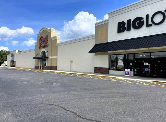
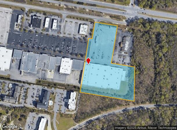
Property Record
2530 David H Mcleod Blvd, Florence, SC 29501
Current Lease Availabilities
General Retail LEASE
Negotiable
18,134 - 43,276 SF
NEARBY LISTINGS FOR SALE OR LEASE
Property Detail
2530 David H Mcleod Blvd
00099-01-066
MCLEOD BLVD STORE #630
Wholesaleoutletdiscountstore
Florence
X
South Carolina
45041C0137E
7.72 AC
2024
Florence/Dillon
2024
Other Market Areas
000201
Florence, SC
115,500 SF
DEMOGRAPHICS near 2530 David H Mcleod Blvd
1 Mile
3 Mile
5 Mile
2024 Total Population
2,600
34,308
67,914
2029 Population
2,520
34,045
67,555
Pop Growth 2024-2029
(3.08%)
(0.77%)
(0.53%)
Average Age
40
40
40
2024 Total Households
1,220
14,320
27,807
HH Growth 2024-2029
(3.28%)
(0.87%)
(0.54%)
Median Household Inc
$56,751
$70,124
$61,873
Avg Household Size
2.10
2.30
2.40
2024 Avg HH Vehicles
2.00
2.00
2.00
Median Home Value
$231,609
$198,427
$188,331
Median Year Built
1981
1983
1984
Nearby Places
Map Layers
Map Styles
 Street
 Aerial
- Restaurants
- Banks
- Shops
- Fitness
- Groceries
PUBLIC TRANSPORTATION
COMMUTER RAIL
Florence Amtrak Station (Palmetto - Amtrak, Silver Meteor - Amtrak)
DRIVE
WALK
Distance
Florence Amtrak Station (Palmetto - Amtrak, Silver Meteor - Amtrak)
11 min
4.7 mi
Freight Ports
North Charleston Terminal
DRIVE
WALK
Distance
North Charleston Terminal
136 min
121.8 mi
Nearby Properties
Address
Land Use
TOTAL SIZE
Lot Size
Zoning
Address
Land Use
TOTAL SIZE
Lot Size
Zoning
492,953 SF
68.41 AC
PDD
Address
Land Use
TOTAL SIZE
Lot Size
Zoning
26,703 SF
24.91 AC
Address
Land Use
TOTAL SIZE
Lot Size
Zoning
194,083 SF
27.70 AC
B3
Address
Land Use
TOTAL SIZE
Lot Size
Zoning
97,000 SF
50.87 AC
Address
Land Use
TOTAL SIZE
Lot Size
Zoning
7,746 SF
9.01 AC
Address
Land Use
TOTAL SIZE
Lot Size
Zoning
13,198 SF
12.29 AC
Address
Land Use
TOTAL SIZE
Lot Size
Zoning
218,026 SF
27.49 AC
Address
Land Use
TOTAL SIZE
Lot Size
Zoning
900 SF
17.01 AC
Address
Land Use
TOTAL SIZE
Lot Size
Zoning
587 SF
2.31 AC
Address
Land Use
TOTAL SIZE
Lot Size
Zoning
49,190 SF
5.40 AC
Address
Land Use
TOTAL SIZE
Lot Size
Zoning
8,800 SF
15.25 AC
Address
Land Use
TOTAL SIZE
Lot Size
Zoning
16,600 SF
11.03 AC
Address
Land Use
TOTAL SIZE
Lot Size
Zoning
85,251 SF
2 AC
Address
Land Use
TOTAL SIZE
Lot Size
Zoning
99,628 SF
19.35 AC
Address
Land Use
TOTAL SIZE
Lot Size
Zoning
1,920 SF
13.25 AC
R5
Address
Land Use
TOTAL SIZE
Lot Size
Zoning
31,860 SF
12.23 AC
PDD
Address
Land Use
TOTAL SIZE
Lot Size
Zoning
89,105 SF
6.24 AC
Address
Land Use
TOTAL SIZE
Lot Size
Zoning
4,000 SF
6.22 AC
Address
Land Use
TOTAL SIZE
Lot Size
Zoning
12,498 SF
10.56 AC
Address
Land Use
TOTAL SIZE
Lot Size
Zoning
86.02 AC
Address
Land Use
TOTAL SIZE
Lot Size
Zoning
66,833 SF
2.74 AC
Address
Land Use
TOTAL SIZE
Lot Size
Zoning
72,270 SF
3.80 AC
PDD
Address
Land Use
TOTAL SIZE
Lot Size
Zoning
114,613 SF
11.74 AC
Address
Land Use
TOTAL SIZE
Lot Size
Zoning
35,770 SF
6.40 AC
B3
Address
Land Use
TOTAL SIZE
Lot Size
Zoning
135,620 SF
12.97 AC
B3
Address
Land Use
TOTAL SIZE
Lot Size
Zoning
29,521 SF
7.84 AC
Address
Land Use
TOTAL SIZE
Lot Size
Zoning
58,314 SF
5.27 AC
Address
Land Use
TOTAL SIZE
Lot Size
Zoning
60,128 SF
2 AC
Address
Land Use
TOTAL SIZE
Lot Size
Zoning
18,500 SF
3.55 AC
The World's #1 Commercial Real Estate Marketplace
Connect with us
© 2025 CoStar Group
The information above has been obtained from sources believed reliable. While we do not doubt its accuracy we have not verified it and make no guarantee, warranty or representation about it. It is your responsibility to independently confirm its accuracy and completeness. Any projections, opinions, assumptions, or estimates used are for example only and do not represent the current or future performance of the property. The value of this transaction to you depends on tax and other factors which should be evaluated by your tax, financial, and legal advisors. You and your advisors should conduct a careful, independent investigation of the property to determine to your satisfaction the suitability of the property for your needs.