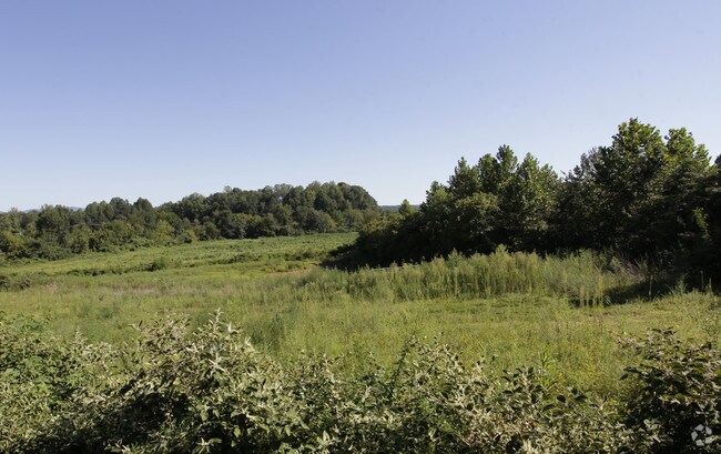
Property Record
2530 Geer Hwy, Marietta, SC 29661
NEARBY LISTINGS FOR SALE OR LEASE
-
-
No Photo
-
-
View all Marietta listings for sale on LoopNet.com
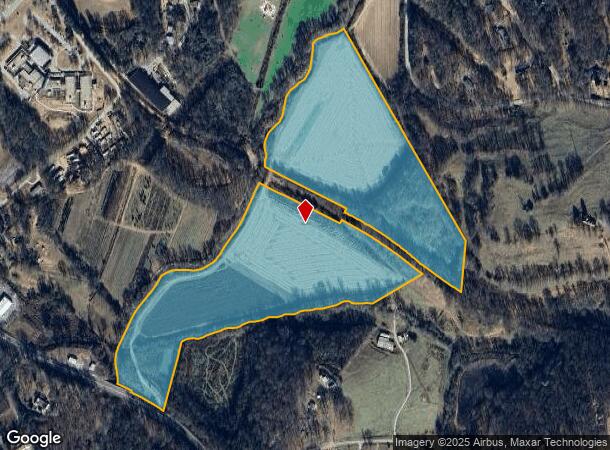
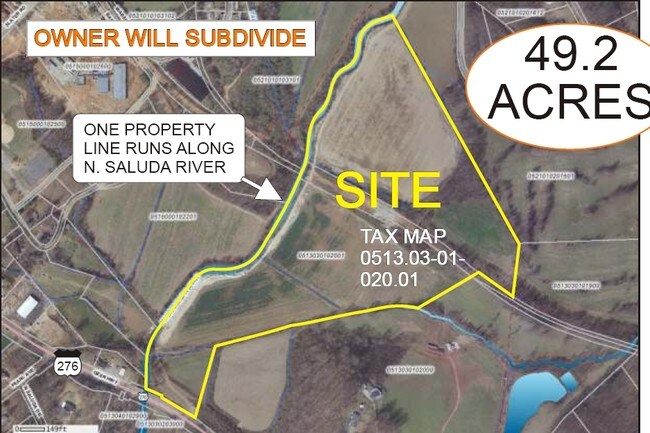
Property Detail
2530 Geer Hwy
Greenville-Anderson-Greer, SC
MAP 0513.03
0513.03-01-020.01
Greenville
Residentialacreage
South Carolina
A
020.01
45045C0215F
46.90 AC
0
Travelers Rest
2024
Greenville/Spartanburg
004101
DEMOGRAPHICS near 2530 Geer Hwy
1 Mile
3 Mile
5 Mile
2024 Total Population
1,566
7,208
18,377
2029 Population
1,734
7,977
20,356
Pop Growth 2024-2029
+ 10.73%
+ 10.67%
+ 10.77%
Average Age
42
42
42
2024 Total Households
617
2,800
7,185
HH Growth 2024-2029
+ 10.86%
+ 10.79%
+ 10.88%
Median Household Inc
$53,139
$51,956
$49,860
Avg Household Size
2.50
2.50
2.50
2024 Avg HH Vehicles
2.00
2.00
2.00
Median Home Value
$137,980
$183,995
$217,857
Median Year Built
1987
1988
1990
Nearby Places
Map Layers
Map Styles
 Street
 Aerial
- Restaurants
- Banks
- Shops
- Fitness
- Groceries
PUBLIC TRANSPORTATION
AIRPORT
Greenville Spartanburg International
DRIVE
WALK
Distance
Greenville Spartanburg International
49 min
27.8 mi
Asheville Regional
DRIVE
WALK
Distance
Asheville Regional
54 min
39.2 mi
Freight Ports
North Charleston Terminal
DRIVE
WALK
Distance
North Charleston Terminal
257 min
218.4 mi
Nearby Properties
Address
Land Use
TOTAL SIZE
Lot Size
Zoning
Address
Land Use
TOTAL SIZE
Lot Size
Zoning
35 AC
C2
Address
Land Use
TOTAL SIZE
Lot Size
Zoning
1.26 AC
RS
Address
Land Use
TOTAL SIZE
Lot Size
Zoning
15.31 AC
UNZONED
Address
Land Use
TOTAL SIZE
Lot Size
Zoning
9.31 AC
UNZONED
Address
Land Use
TOTAL SIZE
Lot Size
Zoning
4.40 AC
I1
Address
Land Use
TOTAL SIZE
Lot Size
Zoning
1.10 AC
UNZONED
Address
Land Use
TOTAL SIZE
Lot Size
Zoning
9.70 AC
RS
Address
Land Use
TOTAL SIZE
Lot Size
Zoning
10.60 AC
RS
Address
Land Use
TOTAL SIZE
Lot Size
Zoning
8.90 AC
S1
Address
Land Use
TOTAL SIZE
Lot Size
Zoning
1.26 AC
UNZONED
Address
Land Use
TOTAL SIZE
Lot Size
Zoning
6.20 AC
RS
Address
Land Use
TOTAL SIZE
Lot Size
Zoning
1,920 SF
9.10 AC
UNZONED
Address
Land Use
TOTAL SIZE
Lot Size
Zoning
36.30 AC
UNZONED
Address
Land Use
TOTAL SIZE
Lot Size
Zoning
14.17 AC
C1
Address
Land Use
TOTAL SIZE
Lot Size
Zoning
32.90 AC
RS
Address
Land Use
TOTAL SIZE
Lot Size
Zoning
5.30 AC
RS
Address
Land Use
TOTAL SIZE
Lot Size
Zoning
240 SF
1.30 AC
UNZONED
Address
Land Use
TOTAL SIZE
Lot Size
Zoning
1,870 SF
0.50 AC
UNZONED
Address
Land Use
TOTAL SIZE
Lot Size
Zoning
24.60 AC
UNZONED
Address
Land Use
TOTAL SIZE
Lot Size
Zoning
23 AC
UNZONED
Address
Land Use
TOTAL SIZE
Lot Size
Zoning
20.40 AC
I1
Address
Land Use
TOTAL SIZE
Lot Size
Zoning
20.30 AC
UNZONED
Address
Land Use
TOTAL SIZE
Lot Size
Zoning
18.92 AC
UNZONED
Address
Land Use
TOTAL SIZE
Lot Size
Zoning
2 AC
UNZONED
Address
Land Use
TOTAL SIZE
Lot Size
Zoning
1.58 AC
RS
Address
Land Use
TOTAL SIZE
Lot Size
Zoning
15.10 AC
UNZONED
Address
Land Use
TOTAL SIZE
Lot Size
Zoning
14.10 AC
UNZONED
Address
Land Use
TOTAL SIZE
Lot Size
Zoning
12.20 AC
UNZONED
Address
Land Use
TOTAL SIZE
Lot Size
Zoning
18.50 AC
UNZONED
The World's #1 Commercial Real Estate Marketplace
Connect with us
© 2026 CoStar Group
The information above has been obtained from sources believed reliable. While we do not doubt its accuracy we have not verified it and make no guarantee, warranty or representation about it. It is your responsibility to independently confirm its accuracy and completeness. Any projections, opinions, assumptions, or estimates used are for example only and do not represent the current or future performance of the property. The value of this transaction to you depends on tax and other factors which should be evaluated by your tax, financial, and legal advisors. You and your advisors should conduct a careful, independent investigation of the property to determine to your satisfaction the suitability of the property for your needs.