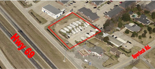
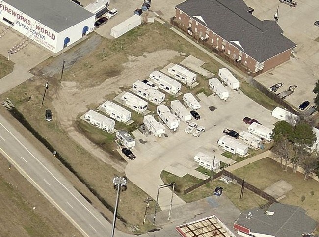
Property Record
2530 Highway 69 N, Nederland, TX 77627
NEARBY LISTINGS FOR SALE OR LEASE
Property Detail
2530 Highway 69 N
Port Arthur
Tanner Lane Commercial Park
Beaumont/Port Arthur
Jefferson
Beaumont-Port Arthur, TX
Texas
063725-000-000100-00000
1.15 AC
Commercialnec
DEMOGRAPHICS near 2530 Highway 69 N
1 Mile
3 Mile
5 Mile
2024 Total Population
5,207
29,962
54,958
2029 Population
5,073
29,204
53,439
Pop Growth 2024-2029
(2.57%)
(2.53%)
(2.76%)
Average Age
40
40
40
2024 Total Households
1,922
10,609
19,736
HH Growth 2024-2029
(2.71%)
(2.91%)
(3.27%)
Median Household Inc
$98,209
$78,665
$72,632
Avg Household Size
2.70
2.50
2.40
2024 Avg HH Vehicles
2.00
2.00
2.00
Median Home Value
$290,328
$186,670
$191,982
Median Year Built
1991
1974
1976
Nearby Places
Map Layers
Map Styles
 Street
 Aerial
- Restaurants
- Banks
- Shops
- Fitness
- Groceries
SALE & LEASE HISTORY
LISTING DATE
SALE/LEASE

Oct 03, 2017
For Sale
Nearby Properties
Address
Land Use
TOTAL SIZE
Lot Size
Zoning
Address
Land Use
TOTAL SIZE
Lot Size
Zoning
351,556 SF
18.92 AC
Address
Land Use
TOTAL SIZE
Lot Size
Zoning
221,714 SF
13.91 AC
Address
Land Use
TOTAL SIZE
Lot Size
Zoning
164,371 SF
7.32 AC
Address
Land Use
TOTAL SIZE
Lot Size
Zoning
67,048 SF
5.40 AC
Address
Land Use
TOTAL SIZE
Lot Size
Zoning
136,295 SF
5.30 AC
Address
Land Use
TOTAL SIZE
Lot Size
Zoning
56,546 SF
12.50 AC
Address
Land Use
TOTAL SIZE
Lot Size
Zoning
63,836 SF
0.64 AC
Address
Land Use
TOTAL SIZE
Lot Size
Zoning
203,821 SF
19.68 AC
Address
Land Use
TOTAL SIZE
Lot Size
Zoning
303,400 SF
14.15 AC
Address
Land Use
TOTAL SIZE
Lot Size
Zoning
110,499 SF
4.80 AC
Address
Land Use
TOTAL SIZE
Lot Size
Zoning
18,795 SF
2.50 AC
Address
Land Use
TOTAL SIZE
Lot Size
Zoning
628,811 SF
38.48 AC
Address
Land Use
TOTAL SIZE
Lot Size
Zoning
55,953 SF
1.87 AC
Address
Land Use
TOTAL SIZE
Lot Size
Zoning
81,675 SF
4.28 AC
Address
Land Use
TOTAL SIZE
Lot Size
Zoning
62,233 SF
6.94 AC
Address
Land Use
TOTAL SIZE
Lot Size
Zoning
121,752 SF
9.88 AC
Address
Land Use
TOTAL SIZE
Lot Size
Zoning
45,252 SF
13.70 AC
Address
Land Use
TOTAL SIZE
Lot Size
Zoning
101,740 SF
4.30 AC
Address
Land Use
TOTAL SIZE
Lot Size
Zoning
38,128 SF
1.93 AC
Address
Land Use
TOTAL SIZE
Lot Size
Zoning
134,498 SF
8.26 AC
Address
Land Use
TOTAL SIZE
Lot Size
Zoning
81,881 SF
4.25 AC
Address
Land Use
TOTAL SIZE
Lot Size
Zoning
50,400 SF
72.96 AC
Address
Land Use
TOTAL SIZE
Lot Size
Zoning
80,441 SF
3.23 AC
Address
Land Use
TOTAL SIZE
Lot Size
Zoning
3,856 SF
20.59 AC
Address
Land Use
TOTAL SIZE
Lot Size
Zoning
95,366 SF
5.85 AC
Address
Land Use
TOTAL SIZE
Lot Size
Zoning
70,361 SF
3.66 AC
Address
Land Use
TOTAL SIZE
Lot Size
Zoning
87,616 SF
9.96 AC
Address
Land Use
TOTAL SIZE
Lot Size
Zoning
41,846 SF
10 AC
Address
Land Use
TOTAL SIZE
Lot Size
Zoning
25,108 SF
1.03 AC
Address
Land Use
TOTAL SIZE
Lot Size
Zoning
29,370 SF
12.83 AC
The World's #1 Commercial Real Estate Marketplace
Connect with us
© 2026 CoStar Group
The information above has been obtained from sources believed reliable. While we do not doubt its accuracy we have not verified it and make no guarantee, warranty or representation about it. It is your responsibility to independently confirm its accuracy and completeness. Any projections, opinions, assumptions, or estimates used are for example only and do not represent the current or future performance of the property. The value of this transaction to you depends on tax and other factors which should be evaluated by your tax, financial, and legal advisors. You and your advisors should conduct a careful, independent investigation of the property to determine to your satisfaction the suitability of the property for your needs.