Property Record
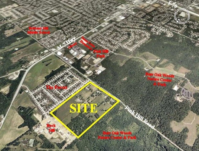
25300 E Pink Hill Rd, Independence, MO 64015

Save to a Folder
{{folder.Name}}
{{folder.ListingIds.length}} Properties
{{folder.ListingIds.length}} Property
Create a New Folder
Property Detail
25300 E Pink Hill Rd
Kansas City, MO-KS
SEC-13 TWP-49 RNG-31---PT W 1/2 OF SE 1/4 DAF: BEG AT TH SW COR OF LOT 102 ROCK HILL 3RD PLAT TH S 88 DEG 22 MIN 20 SEC E 880 MOL TH S 02 DEG 37 MIN 00 SEC W 913.48 TO TH E LI LO
24-740-01-03-01-0-00-000
JACKSON
Agriculturalland
Missouri
B and X Area of moderate flood hazard, usually the area between the limits of the 100-year and 500-year floods.
102
2024
14.50 AC
2025
East Jackson County
014124
Kansas City
NEARBY LISTINGS FOR SALE OR LEASE
-
-
-
-
-
-
No Photo
-
View all Independence listings for sale on LoopNet.com
DEMOGRAPHICS near 25300 E Pink Hill Rd
1 mile
3 mile
5 mile
2025 Total Population
2,763
33,938
83,876
2030 Population
2,770
33,939
84,248
Pop Growth 2025-2030
+ 0.25%
0.00%
+ 0.44%
Average Age
39
40
40
2025 Total Households
944
12,742
32,007
HH Growth 2025-2030
+ 0.11%
+ 0.01%
+ 0.47%
Median Household Inc
$92,809
$87,584
$85,783
Avg Household Size
2.90
2.60
2.60
2025 Avg HH Vehicles
2.00
2.00
2.00
Median Home Value
$277,777
$274,741
$267,730
Median Year Built
1986
1985
1988
Nearby Places
Map Layers
Map Styles
 Street
 Aerial
Layers
 Traffic
 Biking
Places
Listings with unknown addresses are not visible on the map
- Restaurants
- Banks
- Shops
- Fitness
- Groceries
PUBLIC TRANSPORTATION
AIRPORT
Kansas City International
Drive
Walk
Distance
Kansas City International
56 min
41.1 mi
Freight Ports
Tulsa Port Of Catoosa
Drive
Walk
Distance
Tulsa Port Of Catoosa
285 min
255.0 mi
Nearby Properties
Address
Land Use
TOTAL SIZE
Lot Size
Zoning
Address
Land Use
TOTAL SIZE
Lot Size
Zoning
448,225 SF
38.38 AC
Address
Land Use
TOTAL SIZE
Lot Size
Zoning
150,684 SF
55.92 AC
Address
Land Use
TOTAL SIZE
Lot Size
Zoning
228,168 SF
25.12 AC
Address
Land Use
TOTAL SIZE
Lot Size
Zoning
28,639 SF
10.40 AC
Address
Land Use
TOTAL SIZE
Lot Size
Zoning
120,053 SF
13.53 AC
Address
Land Use
TOTAL SIZE
Lot Size
Zoning
287,132 SF
Address
Land Use
TOTAL SIZE
Lot Size
Zoning
286,547 SF
Address
Land Use
TOTAL SIZE
Lot Size
Zoning
127,621 SF
23 AC
Address
Land Use
TOTAL SIZE
Lot Size
Zoning
214,518 SF
22.16 AC
Address
Land Use
TOTAL SIZE
Lot Size
Zoning
129,570 SF
18.40 AC
Address
Land Use
TOTAL SIZE
Lot Size
Zoning
71,169 SF
0.82 AC
Address
Land Use
TOTAL SIZE
Lot Size
Zoning
98,523 SF
9.48 AC
Address
Land Use
TOTAL SIZE
Lot Size
Zoning
36,952 SF
20.90 AC
Address
Land Use
TOTAL SIZE
Lot Size
Zoning
48,270 SF
4.61 AC
Address
Land Use
TOTAL SIZE
Lot Size
Zoning
49,601 SF
8.03 AC
Address
Land Use
TOTAL SIZE
Lot Size
Zoning
98,600 SF
4.50 AC
Address
Land Use
TOTAL SIZE
Lot Size
Zoning
130,178 SF
10.25 AC
Address
Land Use
TOTAL SIZE
Lot Size
Zoning
75,977 SF
8.86 AC
Address
Land Use
TOTAL SIZE
Lot Size
Zoning
36,000 SF
5.22 AC
Address
Land Use
TOTAL SIZE
Lot Size
Zoning
61,567 SF
10 AC
Address
Land Use
TOTAL SIZE
Lot Size
Zoning
53,384 SF
6.24 AC
Address
Land Use
TOTAL SIZE
Lot Size
Zoning
64,887 SF
17.50 AC
Address
Land Use
TOTAL SIZE
Lot Size
Zoning
95,342 SF
11.02 AC
Address
Land Use
TOTAL SIZE
Lot Size
Zoning
33,698 SF
Address
Land Use
TOTAL SIZE
Lot Size
Zoning
65,659 SF
12.60 AC
Address
Land Use
TOTAL SIZE
Lot Size
Zoning
15,656 SF
9.53 AC
Address
Land Use
TOTAL SIZE
Lot Size
Zoning
101,280 SF
5.27 AC
Address
Land Use
TOTAL SIZE
Lot Size
Zoning
47,082 SF
11.30 AC
Address
Land Use
TOTAL SIZE
Lot Size
Zoning
75,053 SF
7.99 AC
Address
Land Use
TOTAL SIZE
Lot Size
Zoning
40,866 SF
4.26 AC
The World's #1 Commercial Real Estate Marketplace
Connect with us
© 2026 CoStar Group
The information above has been obtained from sources believed reliable. While we do not doubt its accuracy we have not verified it and make no guarantee, warranty or representation about it. It is your responsibility to independently confirm its accuracy and completeness. Any projections, opinions, assumptions, or estimates used are for example only and do not represent the current or future performance of the property. The value of this transaction to you depends on tax and other factors which should be evaluated by your tax, financial, and legal advisors. You and your advisors should conduct a careful, independent investigation of the property to determine to your satisfaction the suitability of the property for your needs.