Property Record
2534 E Manning Ave, Fresno, CA 93725

Property Detail
2534 E Manning Ave
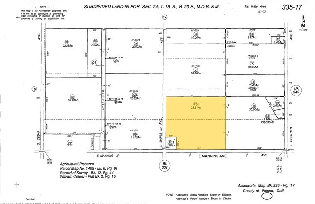
335-170-22S
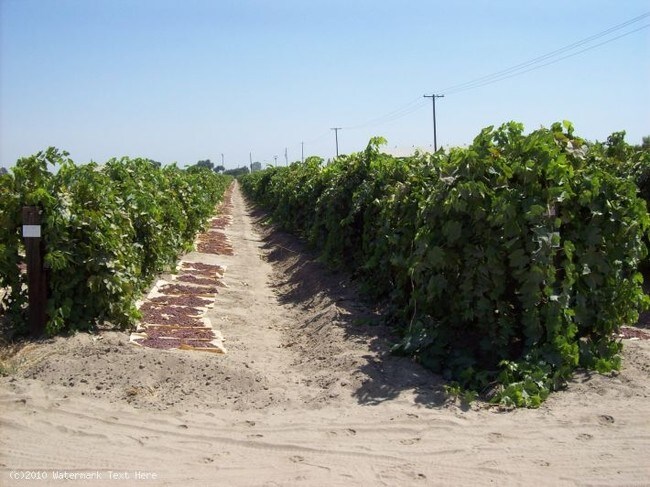
SUR RT 33.61 AC IN W1/2 OF LOTS 8 9 WITTRAM COL
Farms
FRESNO
AE20
California
B and X Area of moderate flood hazard, usually the area between the limits of the 100-year and 500-year floods.
9
2025
32.89 AC
2025
W Outlying Fresno County
001700
Fresno
1,466 SF
Fresno, CA
NEARBY LISTINGS FOR SALE OR LEASE
-
-
View all Fresno listings for sale on LoopNet.com
DEMOGRAPHICS near 2534 E Manning Ave
1 mile
3 mile
5 mile
2025 Total Population
338
3,257
17,534
2030 Population
331
3,233
17,707
Pop Growth 2025-2030
(2.07%)
(0.74%)
+ 0.99%
Average Age
39
38
38
2025 Total Households
106
946
5,233
HH Growth 2025-2030
(1.89%)
(0.85%)
+ 0.92%
Median Household Inc
$96,052
$85,651
$73,132
Avg Household Size
3.10
3.30
3.30
2025 Avg HH Vehicles
2.00
2.00
2.00
Median Home Value
$460,526
$437,890
$420,320
Median Year Built
1970
1970
1975
Nearby Places
Map Layers
Map Styles
 Street
 Aerial
Layers
 Traffic
 Biking
Places
Listings with unknown addresses are not visible on the map
- Restaurants
- Banks
- Shops
- Fitness
- Groceries
PUBLIC TRANSPORTATION
AIRPORT
Fresno Yosemite International
Drive
Walk
Distance
Fresno Yosemite International
24 min
17.1 mi
Freight Ports
Port of Stockton
Drive
Walk
Distance
Port of Stockton
164 min
138.3 mi
Nearby Properties
Address
Land Use
TOTAL SIZE
Lot Size
Zoning
Address
Land Use
TOTAL SIZE
Lot Size
Zoning
369,206 SF
35.93 AC
AE20
Address
Land Use
TOTAL SIZE
Lot Size
Zoning
111,743 SF
7.21 AC
AE20
Address
Land Use
TOTAL SIZE
Lot Size
Zoning
293,312 SF
26.40 AC
M3
Address
Land Use
TOTAL SIZE
Lot Size
Zoning
1,610 SF
116.80 AC
AE20
Address
Land Use
TOTAL SIZE
Lot Size
Zoning
13,277 SF
2.17 AC
RS
Address
Land Use
TOTAL SIZE
Lot Size
Zoning
1,295 SF
38.18 AC
AE20
Address
Land Use
TOTAL SIZE
Lot Size
Zoning
3,405 SF
82.44 AC
AE20
Address
Land Use
TOTAL SIZE
Lot Size
Zoning
20,048 SF
1.72 AC
M3
Address
Land Use
TOTAL SIZE
Lot Size
Zoning
19.55 AC
AE20
Address
Land Use
TOTAL SIZE
Lot Size
Zoning
37.78 AC
AE20
Address
Land Use
TOTAL SIZE
Lot Size
Zoning
1,490 SF
30 AC
Address
Land Use
TOTAL SIZE
Lot Size
Zoning
40 AC
AE20
Address
Land Use
TOTAL SIZE
Lot Size
Zoning
1,176 SF
36.38 AC
AE20
Address
Land Use
TOTAL SIZE
Lot Size
Zoning
7,326 SF
18.96 AC
AE20
Address
Land Use
TOTAL SIZE
Lot Size
Zoning
18.65 AC
AE20
Address
Land Use
TOTAL SIZE
Lot Size
Zoning
800 SF
40 AC
AE20
Address
Land Use
TOTAL SIZE
Lot Size
Zoning
2,654 SF
86.29 AC
AE20
Address
Land Use
TOTAL SIZE
Lot Size
Zoning
22,438 SF
3.50 AC
AE20
Address
Land Use
TOTAL SIZE
Lot Size
Zoning
962 SF
40 AC
AE20
Address
Land Use
TOTAL SIZE
Lot Size
Zoning
1,656 SF
50 AC
AE20
Address
Land Use
TOTAL SIZE
Lot Size
Zoning
1,846 SF
60 AC
AE20
Address
Land Use
TOTAL SIZE
Lot Size
Zoning
2,006 SF
28.49 AC
AE20
Address
Land Use
TOTAL SIZE
Lot Size
Zoning
113.50 AC
Address
Land Use
TOTAL SIZE
Lot Size
Zoning
2,870 SF
75.89 AC
AE20
Address
Land Use
TOTAL SIZE
Lot Size
Zoning
988 SF
23.20 AC
Address
Land Use
TOTAL SIZE
Lot Size
Zoning
10,640 SF
9.51 AC
AE20
Address
Land Use
TOTAL SIZE
Lot Size
Zoning
39.34 AC
AE20
Address
Land Use
TOTAL SIZE
Lot Size
Zoning
35.64 AC
AE20
The World's #1 Commercial Real Estate Marketplace
Connect with us
© 2026 CoStar Group
The information above has been obtained from sources believed reliable. While we do not doubt its accuracy we have not verified it and make no guarantee, warranty or representation about it. It is your responsibility to independently confirm its accuracy and completeness. Any projections, opinions, assumptions, or estimates used are for example only and do not represent the current or future performance of the property. The value of this transaction to you depends on tax and other factors which should be evaluated by your tax, financial, and legal advisors. You and your advisors should conduct a careful, independent investigation of the property to determine to your satisfaction the suitability of the property for your needs.