Property Record
2535 Lawrence Dr, De Pere, WI 54115
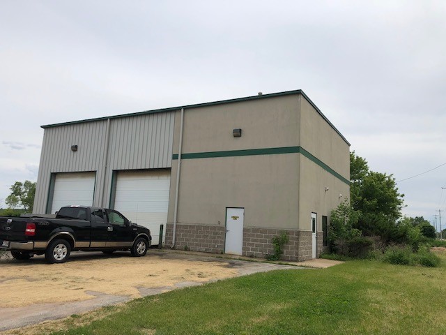


Property Detail
2535 Lawrence Dr
Green Bay, WI
128,821 SQ FT LOT 1 OF 39 CSM 3 AS COR IN 1694267 BNG PRT OF LOT 99 SUBD OF WILLIAMS GRANT EX RD IN 2205755
WD-L482-1
Brown
Commercialnec
Wisconsin
B and X Area of moderate flood hazard, usually the area between the limits of the 100-year and 500-year floods.
1,99
2025
2.96 AC
2025
Ashwaubenon
940007
Green Bay
2,400 SF
NEARBY LISTINGS FOR SALE OR LEASE
DEMOGRAPHICS near 2535 Lawrence Dr
1 mile
3 mile
5 mile
2025 Total Population
2,568
12,851
34,945
2030 Population
2,672
13,294
35,867
Pop Growth 2025-2030
+ 4.05%
+ 3.45%
+ 2.64%
Average Age
37
38
39
2025 Total Households
972
4,982
13,693
HH Growth 2025-2030
+ 4.01%
+ 3.41%
+ 2.74%
Median Household Inc
$105,190
$106,151
$93,124
Avg Household Size
2.60
2.50
2.40
2025 Avg HH Vehicles
2.00
2.00
2.00
Median Home Value
$377,168
$374,813
$339,138
Median Year Built
2005
2004
1997
Nearby Places
Map Layers
Map Styles
 Street
 Aerial
Layers
 Traffic
 Biking
Places
Listings with unknown addresses are not visible on the map
- Restaurants
- Banks
- Shops
- Fitness
- Groceries
PUBLIC TRANSPORTATION
AIRPORT
Green Bay/Austin Straubel International
Drive
Walk
Distance
Green Bay/Austin Straubel International
16 min
8.4 mi
Appleton International
Drive
Walk
Distance
Appleton International
34 min
26.9 mi
Freight Ports
Port Milwaukee
Drive
Walk
Distance
Port Milwaukee
144 min
123.9 mi
SALE & LEASE HISTORY
LISTING DATE
SALE/LEASE

Jul 24, 2019
For Sale
Nearby Properties
Address
Land Use
TOTAL SIZE
Lot Size
Zoning
Address
Land Use
TOTAL SIZE
Lot Size
Zoning
1,108,080 SF
76.76 AC
Address
Land Use
TOTAL SIZE
Lot Size
Zoning
55.96 AC
Address
Land Use
TOTAL SIZE
Lot Size
Zoning
452,950 SF
34.59 AC
Address
Land Use
TOTAL SIZE
Lot Size
Zoning
175,271 SF
17.86 AC
Address
Land Use
TOTAL SIZE
Lot Size
Zoning
487,996 SF
23.04 AC
Address
Land Use
TOTAL SIZE
Lot Size
Zoning
20.53 AC
Address
Land Use
TOTAL SIZE
Lot Size
Zoning
35.24 AC
Address
Land Use
TOTAL SIZE
Lot Size
Zoning
339,679 SF
56.88 AC
Address
Land Use
TOTAL SIZE
Lot Size
Zoning
53.92 AC
Address
Land Use
TOTAL SIZE
Lot Size
Zoning
240,000 SF
12.56 AC
Address
Land Use
TOTAL SIZE
Lot Size
Zoning
98,000 SF
10.84 AC
Address
Land Use
TOTAL SIZE
Lot Size
Zoning
174,436 SF
12.23 AC
Address
Land Use
TOTAL SIZE
Lot Size
Zoning
200,000 SF
15.27 AC
Address
Land Use
TOTAL SIZE
Lot Size
Zoning
189,186 SF
17.54 AC
Address
Land Use
TOTAL SIZE
Lot Size
Zoning
14.02 AC
Address
Land Use
TOTAL SIZE
Lot Size
Zoning
17.84 AC
Address
Land Use
TOTAL SIZE
Lot Size
Zoning
245,300 SF
17.28 AC
Address
Land Use
TOTAL SIZE
Lot Size
Zoning
200,000 SF
12.34 AC
Address
Land Use
TOTAL SIZE
Lot Size
Zoning
10.06 AC
Address
Land Use
TOTAL SIZE
Lot Size
Zoning
22.64 AC
Address
Land Use
TOTAL SIZE
Lot Size
Zoning
180,760 SF
14.98 AC
Address
Land Use
TOTAL SIZE
Lot Size
Zoning
9.33 AC
Address
Land Use
TOTAL SIZE
Lot Size
Zoning
98,976 SF
8.45 AC
Address
Land Use
TOTAL SIZE
Lot Size
Zoning
92,160 SF
6.81 AC
Address
Land Use
TOTAL SIZE
Lot Size
Zoning
Address
Land Use
TOTAL SIZE
Lot Size
Zoning
18.77 AC
Address
Land Use
TOTAL SIZE
Lot Size
Zoning
82,656 SF
7.20 AC
Address
Land Use
TOTAL SIZE
Lot Size
Zoning
61,800 SF
7.60 AC
Address
Land Use
TOTAL SIZE
Lot Size
Zoning
47,100 SF
3.05 AC
Address
Land Use
TOTAL SIZE
Lot Size
Zoning
23.32 AC
The World's #1 Commercial Real Estate Marketplace
Connect with us
© 2026 CoStar Group
The information above has been obtained from sources believed reliable. While we do not doubt its accuracy we have not verified it and make no guarantee, warranty or representation about it. It is your responsibility to independently confirm its accuracy and completeness. Any projections, opinions, assumptions, or estimates used are for example only and do not represent the current or future performance of the property. The value of this transaction to you depends on tax and other factors which should be evaluated by your tax, financial, and legal advisors. You and your advisors should conduct a careful, independent investigation of the property to determine to your satisfaction the suitability of the property for your needs.