Property Record
25350 Malibu Rd, Malibu, CA 90265


NEARBY LISTINGS FOR SALE OR LEASE
-
-
View all Malibu listings for sale on LoopNet.com
Property Detail
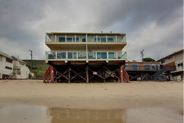
25350 Malibu Rd
Los Angeles-Long Beach-Glendale, CA
The Rancho Topanga Malibu Sequit
4459-017-004
TRACT NO 12939 VAC ST ADJ ON N AND LOT 40
Quadruplex
Los Angeles
VE
California
06037C1536G
40
2024
0.18 AC
2025
Central Malibu
800410
Los Angeles
4,400 SF
DEMOGRAPHICS near 25350 Malibu Rd
1 Mile
3 Mile
5 Mile
2024 Total Population
1,796
6,457
13,291
2029 Population
1,780
6,481
13,409
Pop Growth 2024-2029
(0.89%)
+ 0.37%
+ 0.89%
Average Age
31
37
41
2024 Total Households
322
1,752
4,527
HH Growth 2024-2029
+ 1.55%
+ 2.05%
+ 1.57%
Median Household Inc
$154,375
$179,807
$179,357
Avg Household Size
2.50
2.40
2.40
2024 Avg HH Vehicles
2.00
2.00
2.00
Median Home Value
$1,120,290
$1,130,062
$1,127,123
Median Year Built
1984
1978
1977
Nearby Places
Map Layers
Map Styles
 Street
 Aerial
- Restaurants
- Banks
- Shops
- Fitness
- Groceries
PUBLIC TRANSPORTATION
AIRPORT
Los Angeles International
DRIVE
WALK
Distance
Los Angeles International
42 min
23.5 mi
Bob Hope
DRIVE
WALK
Distance
Bob Hope
50 min
35.0 mi
Long Beach (Daugherty Field)
DRIVE
WALK
Distance
Long Beach (Daugherty Field)
62 min
43.7 mi
Freight Ports
The Port of Hueneme
DRIVE
WALK
Distance
The Port of Hueneme
47 min
32.4 mi
Nearby Properties
Address
Land Use
TOTAL SIZE
Lot Size
Zoning
Address
Land Use
TOTAL SIZE
Lot Size
Zoning
92,514 SF
13.95 AC
LCC2*
Address
Land Use
TOTAL SIZE
Lot Size
Zoning
361,421 SF
33.54 AC
LCA11*
Address
Land Use
TOTAL SIZE
Lot Size
Zoning
39,481 SF
5.97 AC
LCC2*
Address
Land Use
TOTAL SIZE
Lot Size
Zoning
91,005 SF
5.48 AC
LCR112000-
Address
Land Use
TOTAL SIZE
Lot Size
Zoning
175,399 SF
3.01 AC
LCR112000-
Address
Land Use
TOTAL SIZE
Lot Size
Zoning
90,648 SF
41.55 AC
LCSRD-R3-R
Address
Land Use
TOTAL SIZE
Lot Size
Zoning
25,832 SF
2.40 AC
LCC3
Address
Land Use
TOTAL SIZE
Lot Size
Zoning
85,990 SF
2.36 AC
LCC3
Address
Land Use
TOTAL SIZE
Lot Size
Zoning
131,792 SF
3.74 AC
LCA11*
Address
Land Use
TOTAL SIZE
Lot Size
Zoning
4,628 SF
1.52 AC
LCC2*
Address
Land Use
TOTAL SIZE
Lot Size
Zoning
115,673 SF
13.33 AC
LCSRD*
Address
Land Use
TOTAL SIZE
Lot Size
Zoning
40,528 SF
2.89 AC
LCC2DP*
Address
Land Use
TOTAL SIZE
Lot Size
Zoning
121,451 SF
5.19 AC
LCA11*
Address
Land Use
TOTAL SIZE
Lot Size
Zoning
2,468 SF
0.17 AC
LCR106
Address
Land Use
TOTAL SIZE
Lot Size
Zoning
91,531 SF
2.21 AC
LCA11*
Address
Land Use
TOTAL SIZE
Lot Size
Zoning
7.28 AC
LCC2-RR1*
Address
Land Use
TOTAL SIZE
Lot Size
Zoning
50,434 SF
2.63 AC
LCC3*
Address
Land Use
TOTAL SIZE
Lot Size
Zoning
5.02 AC
LCA11*
Address
Land Use
TOTAL SIZE
Lot Size
Zoning
4.88 AC
LCSRD*
Address
Land Use
TOTAL SIZE
Lot Size
Zoning
9.21 AC
LCRR1*
Address
Land Use
TOTAL SIZE
Lot Size
Zoning
1.06 AC
LCA25-A11*
Address
Land Use
TOTAL SIZE
Lot Size
Zoning
2.05 AC
LCR1YY
Address
Land Use
TOTAL SIZE
Lot Size
Zoning
2,144 SF
7.06 AC
LCRR1Y
Address
Land Use
TOTAL SIZE
Lot Size
Zoning
3,354 SF
0.73 AC
LCR3-1*
Address
Land Use
TOTAL SIZE
Lot Size
Zoning
90,183 SF
2.07 AC
LCC3*
Address
Land Use
TOTAL SIZE
Lot Size
Zoning
0.69 AC
LCRA11/2
Address
Land Use
TOTAL SIZE
Lot Size
Zoning
1,050 SF
0.23 AC
LCR171/2
Address
Land Use
TOTAL SIZE
Lot Size
Zoning
15,285 SF
2.33 AC
LCC3*
The World's #1 Commercial Real Estate Marketplace
Connect with us
© 2026 CoStar Group
The information above has been obtained from sources believed reliable. While we do not doubt its accuracy we have not verified it and make no guarantee, warranty or representation about it. It is your responsibility to independently confirm its accuracy and completeness. Any projections, opinions, assumptions, or estimates used are for example only and do not represent the current or future performance of the property. The value of this transaction to you depends on tax and other factors which should be evaluated by your tax, financial, and legal advisors. You and your advisors should conduct a careful, independent investigation of the property to determine to your satisfaction the suitability of the property for your needs.