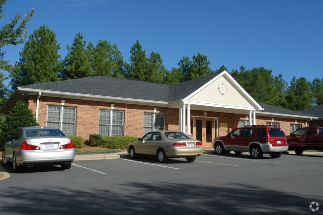
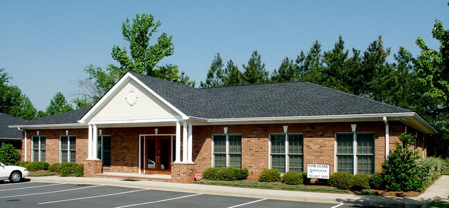
Property Record
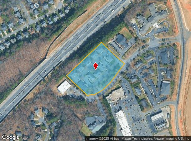
2504 Plantation Center Dr, Matthews, NC 28105

NEARBY LISTINGS FOR SALE OR LEASE
Property Detail
2504 Plantation Center Dr
Charlotte-Concord-Gastonia, NC-SC
Plantation Prof Center Condo
227-561-55
UNIT A BLD1 U/F 466
Officecondo
Mecklenburg
X
North Carolina
3710448900K
99
2024
3.80 AC
2025
Matthews
005851
Charlotte
1,200 SF
DEMOGRAPHICS near 2504 Plantation Center Dr
1 Mile
3 Mile
5 Mile
2024 Total Population
9,025
62,962
154,216
2029 Population
9,466
67,334
164,953
Pop Growth 2024-2029
+ 4.89%
+ 6.94%
+ 6.96%
Average Age
42
41
40
2024 Total Households
3,173
23,349
58,910
HH Growth 2024-2029
+ 5.33%
+ 7.11%
+ 6.97%
Median Household Inc
$130,456
$111,708
$105,024
Avg Household Size
2.80
2.70
2.60
2024 Avg HH Vehicles
2.00
2.00
2.00
Median Home Value
$413,253
$429,944
$420,289
Median Year Built
1998
1996
1994
Nearby Places
- Restaurants
- Banks
- Shops
- Fitness
- Groceries
PUBLIC TRANSPORTATION
AIRPORT
Charlotte/Douglas International
DRIVE
WALK
Distance
Charlotte/Douglas International
34 min
21.3 mi
Concord-Padgett Regional
DRIVE
WALK
Distance
Concord-Padgett Regional
41 min
29.6 mi
Nearby Properties
Address
Land Use
TOTAL SIZE
Lot Size
Zoning
Address
Land Use
TOTAL SIZE
Lot Size
Zoning
1,064,632 SF
73.76 AC
Address
Land Use
TOTAL SIZE
Lot Size
Zoning
466,084 SF
42.13 AC
C
Address
Land Use
TOTAL SIZE
Lot Size
Zoning
395,963 SF
43.37 AC
R15
Address
Land Use
TOTAL SIZE
Lot Size
Zoning
476,565 SF
13.18 AC
Address
Land Use
TOTAL SIZE
Lot Size
Zoning
442,934 SF
40.80 AC
R12MFCD
Address
Land Use
TOTAL SIZE
Lot Size
Zoning
191,929 SF
26.85 AC
B1SCD
Address
Land Use
TOTAL SIZE
Lot Size
Zoning
750,813 SF
56.11 AC
C
Address
Land Use
TOTAL SIZE
Lot Size
Zoning
262,337 SF
7.35 AC
Address
Land Use
TOTAL SIZE
Lot Size
Zoning
282,922 SF
47.76 AC
R4
Address
Land Use
TOTAL SIZE
Lot Size
Zoning
268,545 SF
26.83 AC
R15MFCD
Address
Land Use
TOTAL SIZE
Lot Size
Zoning
288,495 SF
22.35 AC
R9PUD
Address
Land Use
TOTAL SIZE
Lot Size
Zoning
28.27 AC
Address
Land Use
TOTAL SIZE
Lot Size
Zoning
294,525 SF
24.80 AC
C
Address
Land Use
TOTAL SIZE
Lot Size
Zoning
288,504 SF
30.19 AC
RI
Address
Land Use
TOTAL SIZE
Lot Size
Zoning
296,002 SF
3 AC
Address
Land Use
TOTAL SIZE
Lot Size
Zoning
185,878 SF
18.24 AC
CC
Address
Land Use
TOTAL SIZE
Lot Size
Zoning
234,773 SF
12.96 AC
Address
Land Use
TOTAL SIZE
Lot Size
Zoning
256,498 SF
23.52 AC
C
Address
Land Use
TOTAL SIZE
Lot Size
Zoning
241,703 SF
17.43 AC
R12MFCD
Address
Land Use
TOTAL SIZE
Lot Size
Zoning
174,834 SF
2.51 AC
Address
Land Use
TOTAL SIZE
Lot Size
Zoning
231,072 SF
17.52 AC
R15MFCD
Address
Land Use
TOTAL SIZE
Lot Size
Zoning
121,464 SF
13.35 AC
Address
Land Use
TOTAL SIZE
Lot Size
Zoning
185,302 SF
47.89 AC
R3
Address
Land Use
TOTAL SIZE
Lot Size
Zoning
159,801 SF
17.02 AC
CC
Address
Land Use
TOTAL SIZE
Lot Size
Zoning
264,132 SF
58.71 AC
R3
Address
Land Use
TOTAL SIZE
Lot Size
Zoning
214,445 SF
15.80 AC
R15MFCD
Address
Land Use
TOTAL SIZE
Lot Size
Zoning
21.45 AC
Address
Land Use
TOTAL SIZE
Lot Size
Zoning
182,894 SF
14.51 AC
R15MFCD
Address
Land Use
TOTAL SIZE
Lot Size
Zoning
2,062 SF
105.82 AC
B-1SCD
Address
Land Use
TOTAL SIZE
Lot Size
Zoning
73.37 AC
The World's #1 Commercial Real Estate Marketplace
Connect with us
© 2025 CoStar Group
The information above has been obtained from sources believed reliable. While we do not doubt its accuracy we have not verified it and make no guarantee, warranty or representation about it. It is your responsibility to independently confirm its accuracy and completeness. Any projections, opinions, assumptions, or estimates used are for example only and do not represent the current or future performance of the property. The value of this transaction to you depends on tax and other factors which should be evaluated by your tax, financial, and legal advisors. You and your advisors should conduct a careful, independent investigation of the property to determine to your satisfaction the suitability of the property for your needs.