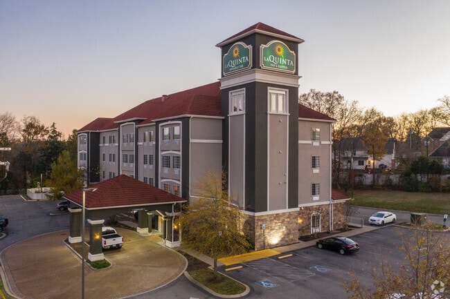
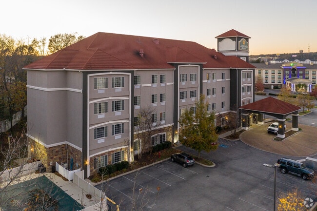
Property Record
2537 Highwood Blvd, Smyrna, TN 37167
Property Detail
2537 Highwood Blvd
032D-B-001.00-000
LOT 62B WOODHAVEN ESTATES SEC 3 RESUB LOT 62 PB 37 PG 167 SPLIT OFF 32D-B-1 FOR 2014
Hotel
Rutherford
CZ
Tennessee
B and X Area of moderate flood hazard, usually the area between the limits of the 100-year and 500-year floods.
62b
2025
1.66 AC
2025
I-24/Murfreesboro
040304
Nashville
10,787 SF
Nashville-Davidson--Murfreesboro--Franklin, TN
NEARBY LISTINGS FOR SALE OR LEASE
-
-
View all Smyrna listings for sale on LoopNet.com
DEMOGRAPHICS near 2537 Highwood Blvd
1 mile
3 mile
5 mile
2025 Total Population
7,713
50,945
109,625
2030 Population
8,556
55,496
119,028
Pop Growth 2025-2030
+ 10.93%
+ 8.93%
+ 8.58%
Average Age
38
37
37
2025 Total Households
2,738
18,253
38,114
HH Growth 2025-2030
+ 10.92%
+ 8.98%
+ 8.67%
Median Household Inc
$93,075
$84,545
$87,185
Avg Household Size
2.70
2.70
2.80
2025 Avg HH Vehicles
2.00
2.00
2.00
Median Home Value
$432,334
$373,954
$380,927
Median Year Built
2008
2001
2001
Nearby Places
Map Layers
Map Styles
 Street
 Aerial
Transit
 Traffic
 Biking
Places
Listings with unknown addresses are not visible on the map
- Restaurants
- Banks
- Shops
- Fitness
- Groceries
PUBLIC TRANSPORTATION
AIRPORT
Nashville International
Drive
Walk
Distance
Nashville International
21 min
15.0 mi
Freight Ports
Port of Mobile
Drive
Walk
Distance
Port of Mobile
492 min
451.5 mi
Nearby Properties
Address
Land Use
TOTAL SIZE
Lot Size
Zoning
Address
Land Use
TOTAL SIZE
Lot Size
Zoning
633,440 SF
134 AC
Address
Land Use
TOTAL SIZE
Lot Size
Zoning
302,040 SF
60 AC
Address
Land Use
TOTAL SIZE
Lot Size
Zoning
323,961 SF
27.38 AC
I-2
Address
Land Use
TOTAL SIZE
Lot Size
Zoning
4,709 SF
25.76 AC
RM14
Address
Land Use
TOTAL SIZE
Lot Size
Zoning
17,953 SF
14.92 AC
Address
Land Use
TOTAL SIZE
Lot Size
Zoning
1,007,188 SF
82.08 AC
Address
Land Use
TOTAL SIZE
Lot Size
Zoning
5,352 SF
30 AC
RMF
Address
Land Use
TOTAL SIZE
Lot Size
Zoning
4,974 SF
18.91 AC
C2
Address
Land Use
TOTAL SIZE
Lot Size
Zoning
588,845 SF
72.56 AC
Address
Land Use
TOTAL SIZE
Lot Size
Zoning
163,177 SF
39.68 AC
Address
Land Use
TOTAL SIZE
Lot Size
Zoning
99,209 SF
44.41 AC
Address
Land Use
TOTAL SIZE
Lot Size
Zoning
2,928 SF
13.60 AC
Address
Land Use
TOTAL SIZE
Lot Size
Zoning
202,737 SF
41 AC
Address
Land Use
TOTAL SIZE
Lot Size
Zoning
768,304 SF
40.03 AC
I-2
Address
Land Use
TOTAL SIZE
Lot Size
Zoning
212,268 SF
49 AC
Address
Land Use
TOTAL SIZE
Lot Size
Zoning
3,142 SF
11.40 AC
C2
Address
Land Use
TOTAL SIZE
Lot Size
Zoning
105,638 SF
17.63 AC
Address
Land Use
TOTAL SIZE
Lot Size
Zoning
121,104 SF
30 AC
Address
Land Use
TOTAL SIZE
Lot Size
Zoning
3,296 SF
14.63 AC
Address
Land Use
TOTAL SIZE
Lot Size
Zoning
22,500 SF
23.38 AC
RM16
Address
Land Use
TOTAL SIZE
Lot Size
Zoning
503,475 SF
22.24 AC
I2
Address
Land Use
TOTAL SIZE
Lot Size
Zoning
121,104 SF
43.60 AC
Address
Land Use
TOTAL SIZE
Lot Size
Zoning
536,732 SF
30.91 AC
I2
Address
Land Use
TOTAL SIZE
Lot Size
Zoning
33,264 SF
27.97 AC
I2
Address
Land Use
TOTAL SIZE
Lot Size
Zoning
512,013 SF
22.78 AC
Address
Land Use
TOTAL SIZE
Lot Size
Zoning
497,452 SF
26.75 AC
I-2
Address
Land Use
TOTAL SIZE
Lot Size
Zoning
518,733 SF
29.59 AC
I-2
Address
Land Use
TOTAL SIZE
Lot Size
Zoning
540,100 SF
32.42 AC
IZ
Address
Land Use
TOTAL SIZE
Lot Size
Zoning
568,258 SF
26 AC
I2
Address
Land Use
TOTAL SIZE
Lot Size
Zoning
503,568 SF
25.06 AC
I-2
The World's #1 Commercial Real Estate Marketplace
Connect with us
© 2026 CoStar Group
The information above has been obtained from sources believed reliable. While we do not doubt its accuracy we have not verified it and make no guarantee, warranty or representation about it. It is your responsibility to independently confirm its accuracy and completeness. Any projections, opinions, assumptions, or estimates used are for example only and do not represent the current or future performance of the property. The value of this transaction to you depends on tax and other factors which should be evaluated by your tax, financial, and legal advisors. You and your advisors should conduct a careful, independent investigation of the property to determine to your satisfaction the suitability of the property for your needs.