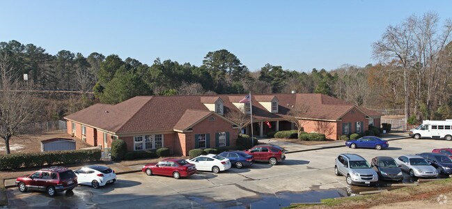
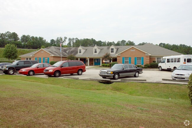
Property Record
248 Furys Ferry Rd, Augusta, GA 30907
NEARBY LISTINGS FOR SALE OR LEASE
Property Detail
248 Furys Ferry Rd
0063001000
TRACT A-2 N/W CORNER FURYS FERRY AND RIVERWATCH
Commercialacreage
Richmond
X
Georgia
13245C0020G
1.93 AC
2025
North Richmond County
2025
Augusta/Richmond County
010104
Augusta-Richmond County, GA-SC
8,629 SF
DEMOGRAPHICS near 248 Furys Ferry Rd
1 Mile
3 Mile
5 Mile
2024 Total Population
7,371
54,863
129,527
2029 Population
7,519
57,104
135,484
Pop Growth 2024-2029
+ 2.01%
+ 4.08%
+ 4.60%
Average Age
41
40
40
2024 Total Households
3,225
23,657
55,343
HH Growth 2024-2029
+ 0.90%
+ 2.77%
+ 3.59%
Median Household Inc
$72,780
$71,446
$67,461
Avg Household Size
2.30
2.30
2.30
2024 Avg HH Vehicles
2.00
2.00
2.00
Median Home Value
$179,381
$221,967
$218,394
Median Year Built
1982
1986
1984
Nearby Places
- Restaurants
- Banks
- Shops
- Fitness
- Groceries
PUBLIC TRANSPORTATION
AIRPORT
Augusta Regional at Bush Field
DRIVE
WALK
Distance
Augusta Regional at Bush Field
27 min
15.7 mi
SALE & LEASE HISTORY
LISTING DATE
SALE/LEASE

Jun 26, 2020
For Lease
Feb 17, 2022
For Sale
Nearby Properties
Address
Land Use
TOTAL SIZE
Lot Size
Zoning
Address
Land Use
TOTAL SIZE
Lot Size
Zoning
8,993 SF
351.84 AC
R-1_B-2
Address
Land Use
TOTAL SIZE
Lot Size
Zoning
371,617 SF
13.26 AC
B-2
Address
Land Use
TOTAL SIZE
Lot Size
Zoning
7,216 SF
53.27 AC
B-1 SPEX
Address
Land Use
TOTAL SIZE
Lot Size
Zoning
4,214 SF
12.73 AC
LI_B-2
Address
Land Use
TOTAL SIZE
Lot Size
Zoning
6,694 SF
17.75 AC
R-3B
Address
Land Use
TOTAL SIZE
Lot Size
Zoning
5,541 SF
14.81 AC
B-2
Address
Land Use
TOTAL SIZE
Lot Size
Zoning
33,784 SF
22.27 AC
B-2
Address
Land Use
TOTAL SIZE
Lot Size
Zoning
4,077 SF
20.88 AC
C-2;GEN CO
Address
Land Use
TOTAL SIZE
Lot Size
Zoning
13.19 AC
Address
Land Use
TOTAL SIZE
Lot Size
Zoning
57,341 SF
54.33 AC
Address
Land Use
TOTAL SIZE
Lot Size
Zoning
3,680 SF
13.42 AC
B-2
Address
Land Use
TOTAL SIZE
Lot Size
Zoning
3,498 SF
12.61 AC
B-2
Address
Land Use
TOTAL SIZE
Lot Size
Zoning
6,516 SF
15.33 AC
R-3B
Address
Land Use
TOTAL SIZE
Lot Size
Zoning
2,326 SF
21.90 AC
R-3B
Address
Land Use
TOTAL SIZE
Lot Size
Zoning
4,800 SF
19.81 AC
B-2
Address
Land Use
TOTAL SIZE
Lot Size
Zoning
3,447 SF
16.67 AC
R-3B
Address
Land Use
TOTAL SIZE
Lot Size
Zoning
61,769 SF
12.06 AC
B-2
Address
Land Use
TOTAL SIZE
Lot Size
Zoning
150,807 SF
16.91 AC
R-1A SPEX
Address
Land Use
TOTAL SIZE
Lot Size
Zoning
114,153 SF
12.91 AC
B-2
Address
Land Use
TOTAL SIZE
Lot Size
Zoning
66,300 SF
18.22 AC
B-1
Address
Land Use
TOTAL SIZE
Lot Size
Zoning
4,108 SF
14.12 AC
B-2
Address
Land Use
TOTAL SIZE
Lot Size
Zoning
8,640 SF
13.15 AC
R-3B
Address
Land Use
TOTAL SIZE
Lot Size
Zoning
112,947 SF
14.91 AC
Address
Land Use
TOTAL SIZE
Lot Size
Zoning
72,381 SF
0.95 AC
Address
Land Use
TOTAL SIZE
Lot Size
Zoning
42,617 SF
40.26 AC
R-1_B-1
Address
Land Use
TOTAL SIZE
Lot Size
Zoning
2,757 SF
19.55 AC
B-2_R-1
Address
Land Use
TOTAL SIZE
Lot Size
Zoning
62,440 SF
5.70 AC
B-2
Address
Land Use
TOTAL SIZE
Lot Size
Zoning
125,466 SF
15.98 AC
B-2
Address
Land Use
TOTAL SIZE
Lot Size
Zoning
2,355 SF
12.97 AC
B-2
Address
Land Use
TOTAL SIZE
Lot Size
Zoning
62,280 SF
22.83 AC
R-3A
The World's #1 Commercial Real Estate Marketplace
Connect with us
© 2025 CoStar Group
The information above has been obtained from sources believed reliable. While we do not doubt its accuracy we have not verified it and make no guarantee, warranty or representation about it. It is your responsibility to independently confirm its accuracy and completeness. Any projections, opinions, assumptions, or estimates used are for example only and do not represent the current or future performance of the property. The value of this transaction to you depends on tax and other factors which should be evaluated by your tax, financial, and legal advisors. You and your advisors should conduct a careful, independent investigation of the property to determine to your satisfaction the suitability of the property for your needs.