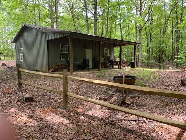
Property Record
129 Crawford Dr, Belton, SC 29627

NEARBY LISTINGS FOR SALE OR LEASE
-
-
View all Belton listings for sale on LoopNet.com
Property Detail
129 Crawford Dr
Greenville-Anderson-Greer, SC
Survey For Crown Properties Llc & Mh Fam
0588.01-01-028.00
MAP 0588.01
Residentialacreage
Greenville
X
South Carolina
45059C0150C
028.00
2025
1 AC
2025
Western Greenville County
003202
Greenville/Spartanburg
864 SF
DEMOGRAPHICS near 129 Crawford Dr
1 mile
3 mile
5 mile
2024 Total Population
431
2,493
7,797
2029 Population
482
2,783
8,673
Pop Growth 2024-2029
+ 11.83%
+ 11.63%
+ 11.24%
Average Age
42
43
43
2024 Total Households
164
971
2,942
HH Growth 2024-2029
+ 12.20%
+ 11.74%
+ 11.42%
Median Household Inc
$64,800
$63,309
$62,301
Avg Household Size
2.60
2.50
2.50
2024 Avg HH Vehicles
2.00
2.00
2.00
Median Home Value
$153,225
$169,999
$198,780
Median Year Built
1991
1990
1990
Nearby Places
Map Layers
Map Styles
 Street
 Aerial
Transit
 Traffic
 Biking
Places
Listings with unknown addresses are not visible on the map
- Restaurants
- Banks
- Shops
- Fitness
- Groceries
PUBLIC TRANSPORTATION
AIRPORT
Greenville Spartanburg International
Drive
Walk
Distance
Greenville Spartanburg International
45 min
31.6 mi
Freight Ports
North Charleston Terminal
Drive
Walk
Distance
North Charleston Terminal
229 min
198.5 mi
SALE & LEASE HISTORY
LISTING DATE
SALE/LEASE

May 09, 2023
For Sale
Nearby Properties
Address
Land Use
TOTAL SIZE
Lot Size
Zoning
Address
Land Use
TOTAL SIZE
Lot Size
Zoning
1,140.92 AC
UNZONED
Address
Land Use
TOTAL SIZE
Lot Size
Zoning
244.20 AC
UNZONED
Address
Land Use
TOTAL SIZE
Lot Size
Zoning
7.76 AC
UNZONED
Address
Land Use
TOTAL SIZE
Lot Size
Zoning
127.40 AC
UNZONED
Address
Land Use
TOTAL SIZE
Lot Size
Zoning
95.12 AC
UNZONED
Address
Land Use
TOTAL SIZE
Lot Size
Zoning
15.70 AC
UNZONED
Address
Land Use
TOTAL SIZE
Lot Size
Zoning
30 AC
UNZONED
Address
Land Use
TOTAL SIZE
Lot Size
Zoning
2,592 SF
11.43 AC
UNZONED
Address
Land Use
TOTAL SIZE
Lot Size
Zoning
24.96 AC
UNZONED
Address
Land Use
TOTAL SIZE
Lot Size
Zoning
17.23 AC
UNZONED
Address
Land Use
TOTAL SIZE
Lot Size
Zoning
18.49 AC
UNZONED
Address
Land Use
TOTAL SIZE
Lot Size
Zoning
10.45 AC
UNZONED
Address
Land Use
TOTAL SIZE
Lot Size
Zoning
8.26 AC
RR3
Address
Land Use
TOTAL SIZE
Lot Size
Zoning
660 SF
5 AC
UNZONED
Address
Land Use
TOTAL SIZE
Lot Size
Zoning
2,554 SF
11 AC
UNZONED
Address
Land Use
TOTAL SIZE
Lot Size
Zoning
6.90 AC
UNZONED
Address
Land Use
TOTAL SIZE
Lot Size
Zoning
5.30 AC
RR3
Address
Land Use
TOTAL SIZE
Lot Size
Zoning
5.27 AC
NZ
Address
Land Use
TOTAL SIZE
Lot Size
Zoning
8,574 SF
7.73 AC
RR3
Address
Land Use
TOTAL SIZE
Lot Size
Zoning
5,464 SF
6.14 AC
RR3
Address
Land Use
TOTAL SIZE
Lot Size
Zoning
1,148 SF
158.60 AC
UNZONED
Address
Land Use
TOTAL SIZE
Lot Size
Zoning
1,980 SF
3.20 AC
UNZONED
Address
Land Use
TOTAL SIZE
Lot Size
Zoning
3.20 AC
UNZONED
Address
Land Use
TOTAL SIZE
Lot Size
Zoning
9.80 AC
RR3
Address
Land Use
TOTAL SIZE
Lot Size
Zoning
3,000 SF
1.80 AC
RR3
Address
Land Use
TOTAL SIZE
Lot Size
Zoning
3,175 SF
5.59 AC
Address
Land Use
TOTAL SIZE
Lot Size
Zoning
3,324 SF
5.05 AC
Address
Land Use
TOTAL SIZE
Lot Size
Zoning
3,389 SF
9.99 AC
UNZONED
Address
Land Use
TOTAL SIZE
Lot Size
Zoning
4,562 SF
6.14 AC
Address
Land Use
TOTAL SIZE
Lot Size
Zoning
3,249 SF
10 AC
RS
The World's #1 Commercial Real Estate Marketplace
Connect with us
© 2026 CoStar Group
The information above has been obtained from sources believed reliable. While we do not doubt its accuracy we have not verified it and make no guarantee, warranty or representation about it. It is your responsibility to independently confirm its accuracy and completeness. Any projections, opinions, assumptions, or estimates used are for example only and do not represent the current or future performance of the property. The value of this transaction to you depends on tax and other factors which should be evaluated by your tax, financial, and legal advisors. You and your advisors should conduct a careful, independent investigation of the property to determine to your satisfaction the suitability of the property for your needs.