Property Record
380 W Marine Dr, Kalama, WA 98625
Save to a Folder
{{folder.Name}}
{{folder.ListingIds.length}} Properties
{{folder.ListingIds.length}} Property
Create a New Folder
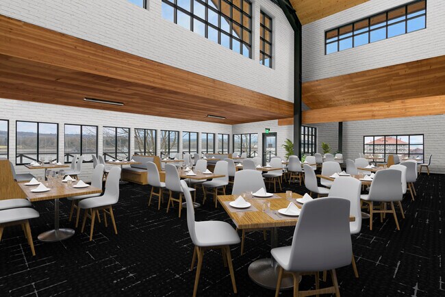
Current Lease Availabilities
Property Detail
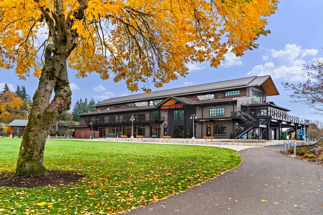
380 W Marine Dr
Longview-Kelso, WA
815 (KALAMA OUTLOT) -KAOL -55A 17 -6N -1W INCL PTN LOT 14 KAL TIDELANDS ALSO AREA GOVT LINE / INNER HARBOR LINE NON OPERATING.
4-1056
COWLITZ
Parkplaygroundpicnicarea
Washington
I01
14
AE The base floodplain where base flood elevations are provided. AE Zones are now used on new format FIRMs instead of A1-A30 Zones.
10.50 AC
2025
Cowlitz County
2025
Portland
001601
NEARBY LISTINGS FOR SALE OR LEASE
-
-
View all Kalama listings for lease on LoopNet.com
DEMOGRAPHICS near 380 W Marine Dr
1 mile
3 mile
5 mile
2025 Total Population
2,385
5,899
10,284
2030 Population
2,451
6,060
10,555
Pop Growth 2025-2030
+ 2.77%
+ 2.73%
+ 2.64%
Average Age
42
43
44
2025 Total Households
934
2,299
3,964
HH Growth 2025-2030
+ 2.78%
+ 2.70%
+ 2.60%
Median Household Inc
$91,356
$104,424
$105,019
Avg Household Size
2.60
2.50
2.60
2025 Avg HH Vehicles
2.00
2.00
2.00
Median Home Value
$488,721
$501,667
$520,891
Median Year Built
1992
1994
1993
Nearby Places
Map Layers
Map Styles
 Street
 Aerial
Layers
 Traffic
 Biking
Places
Listings with unknown addresses are not visible on the map
- Restaurants
- Banks
- Shops
- Fitness
- Groceries
Nearby Properties
Address
Land Use
TOTAL SIZE
Lot Size
Zoning
Address
Land Use
TOTAL SIZE
Lot Size
Zoning
80.24 AC
UZ0
Address
Land Use
TOTAL SIZE
Lot Size
Zoning
154.96 AC
UZ0
Address
Land Use
TOTAL SIZE
Lot Size
Zoning
1,440 SF
85.37 AC
UZ0
Address
Land Use
TOTAL SIZE
Lot Size
Zoning
21.03 AC
UZ0
Address
Land Use
TOTAL SIZE
Lot Size
Zoning
53,442 SF
11.65 AC
UZ0
Address
Land Use
TOTAL SIZE
Lot Size
Zoning
142,354 SF
2.25 AC
R01
Address
Land Use
TOTAL SIZE
Lot Size
Zoning
2.36 AC
UZ0
Address
Land Use
TOTAL SIZE
Lot Size
Zoning
37.27 AC
I01
Address
Land Use
TOTAL SIZE
Lot Size
Zoning
25,702 SF
23.20 AC
I01
Address
Land Use
TOTAL SIZE
Lot Size
Zoning
8.60 AC
UZ0
Address
Land Use
TOTAL SIZE
Lot Size
Zoning
5,376 SF
25.88 AC
UZ0
Address
Land Use
TOTAL SIZE
Lot Size
Zoning
35,453 SF
11.80 AC
UZ0
Address
Land Use
TOTAL SIZE
Lot Size
Zoning
8.13 AC
UZ0
Address
Land Use
TOTAL SIZE
Lot Size
Zoning
5,700 SF
16.28 AC
UZ0
Address
Land Use
TOTAL SIZE
Lot Size
Zoning
6,450 SF
38 AC
Address
Land Use
TOTAL SIZE
Lot Size
Zoning
1.03 AC
UZ0
Address
Land Use
TOTAL SIZE
Lot Size
Zoning
996 SF
4.59 AC
Address
Land Use
TOTAL SIZE
Lot Size
Zoning
12,375 SF
2.35 AC
UZ0
Address
Land Use
TOTAL SIZE
Lot Size
Zoning
10,174 SF
1.62 AC
UZ0
Address
Land Use
TOTAL SIZE
Lot Size
Zoning
9,975 SF
0.16 AC
C01
Address
Land Use
TOTAL SIZE
Lot Size
Zoning
15,386 SF
2.01 AC
Address
Land Use
TOTAL SIZE
Lot Size
Zoning
0.32 AC
C01
Address
Land Use
TOTAL SIZE
Lot Size
Zoning
1,680 SF
4.23 AC
UZ0
Address
Land Use
TOTAL SIZE
Lot Size
Zoning
3,360 SF
0.32 AC
C01
Address
Land Use
TOTAL SIZE
Lot Size
Zoning
0.75 AC
UZ0
Address
Land Use
TOTAL SIZE
Lot Size
Zoning
12,750 SF
0.16 AC
C01
Address
Land Use
TOTAL SIZE
Lot Size
Zoning
6,000 SF
0.16 AC
C01
Address
Land Use
TOTAL SIZE
Lot Size
Zoning
3,250 SF
0.08 AC
C01
The World's #1 Commercial Real Estate Marketplace
Connect with us
© 2026 CoStar Group
The information above has been obtained from sources believed reliable. While we do not doubt its accuracy we have not verified it and make no guarantee, warranty or representation about it. It is your responsibility to independently confirm its accuracy and completeness. Any projections, opinions, assumptions, or estimates used are for example only and do not represent the current or future performance of the property. The value of this transaction to you depends on tax and other factors which should be evaluated by your tax, financial, and legal advisors. You and your advisors should conduct a careful, independent investigation of the property to determine to your satisfaction the suitability of the property for your needs.