Property Record
254 Hornbine Rd, Rehoboth, MA 02769
NEARBY LISTINGS FOR SALE OR LEASE
-
-
View all Rehoboth listings for sale on LoopNet.com
Property Detail
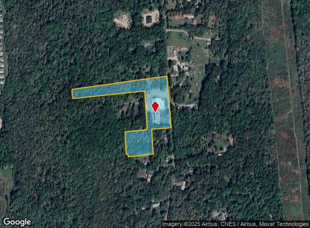
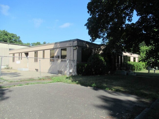
254 Hornbine Rd
Industrialgeneral
Bristol
X
Massachusetts
25005C0237F
10.19 AC
2025
Attleboro/New Bedford
2025
Boston
633200
Providence-Warwick, RI-MA
21,758 SF
REHO-000005-000000-000006
DEMOGRAPHICS near 254 Hornbine Rd
1 Mile
3 Mile
5 Mile
2024 Total Population
993
13,879
57,758
2029 Population
996
13,843
57,632
Pop Growth 2024-2029
+ 0.30%
(0.26%)
(0.22%)
Average Age
42
43
43
2024 Total Households
344
5,036
22,501
HH Growth 2024-2029
+ 0.29%
(0.36%)
(0.24%)
Median Household Inc
$131,962
$113,430
$96,257
Avg Household Size
2.90
2.70
2.50
2024 Avg HH Vehicles
2.00
2.00
2.00
Median Home Value
$433,913
$421,001
$400,881
Median Year Built
1988
1975
1970
Nearby Places
Map Layers
Map Styles
 Street
 Aerial
- Restaurants
- Banks
- Shops
- Fitness
- Groceries
PUBLIC TRANSPORTATION
AIRPORT
Rhode Island Tf Green International
DRIVE
WALK
Distance
Rhode Island Tf Green International
37 min
20.4 mi
Freight Ports
Port of Davisville, RI
DRIVE
WALK
Distance
Port of Davisville, RI
53 min
32.8 mi
SALE & LEASE HISTORY
LISTING DATE
SALE/LEASE

Feb 03, 2023
For Sale
Nearby Properties
Address
Land Use
TOTAL SIZE
Lot Size
Zoning
Address
Land Use
TOTAL SIZE
Lot Size
Zoning
104,822 SF
16.61 AC
R1
Address
Land Use
TOTAL SIZE
Lot Size
Zoning
143,084 SF
12.60 AC
R1
Address
Land Use
TOTAL SIZE
Lot Size
Zoning
152,620 SF
20.73 AC
C
Address
Land Use
TOTAL SIZE
Lot Size
Zoning
137,976 SF
10.59 AC
C
Address
Land Use
TOTAL SIZE
Lot Size
Zoning
70,741 SF
16.24 AC
Address
Land Use
TOTAL SIZE
Lot Size
Zoning
24,480 SF
4.69 AC
C
Address
Land Use
TOTAL SIZE
Lot Size
Zoning
51,308 SF
10.34 AC
C
Address
Land Use
TOTAL SIZE
Lot Size
Zoning
177,003 SF
26.96 AC
C
Address
Land Use
TOTAL SIZE
Lot Size
Zoning
91,510 SF
Address
Land Use
TOTAL SIZE
Lot Size
Zoning
1,800 SF
3.39 AC
R1
Address
Land Use
TOTAL SIZE
Lot Size
Zoning
22,545 SF
7 AC
R1
Address
Land Use
TOTAL SIZE
Lot Size
Zoning
36,188 SF
65 AC
R1
Address
Land Use
TOTAL SIZE
Lot Size
Zoning
91,235 SF
Address
Land Use
TOTAL SIZE
Lot Size
Zoning
112,123 SF
Address
Land Use
TOTAL SIZE
Lot Size
Zoning
23,758 SF
6 AC
C
Address
Land Use
TOTAL SIZE
Lot Size
Zoning
2,878 SF
29.25 AC
R1
Address
Land Use
TOTAL SIZE
Lot Size
Zoning
36,316 SF
8.38 AC
C
Address
Land Use
TOTAL SIZE
Lot Size
Zoning
54,751 SF
4.30 AC
C
Address
Land Use
TOTAL SIZE
Lot Size
Zoning
6,540 SF
27.30 AC
Address
Land Use
TOTAL SIZE
Lot Size
Zoning
46,100 SF
17.79 AC
C
Address
Land Use
TOTAL SIZE
Lot Size
Zoning
27,848 SF
3.37 AC
C
Address
Land Use
TOTAL SIZE
Lot Size
Zoning
48,192 SF
5.62 AC
C
Address
Land Use
TOTAL SIZE
Lot Size
Zoning
8.04 AC
R1
Address
Land Use
TOTAL SIZE
Lot Size
Zoning
50,840 SF
10.85 AC
C
Address
Land Use
TOTAL SIZE
Lot Size
Zoning
5,800 SF
4.35 AC
C
Address
Land Use
TOTAL SIZE
Lot Size
Zoning
5,750 SF
3.09 AC
I
Address
Land Use
TOTAL SIZE
Lot Size
Zoning
31,309 SF
Address
Land Use
TOTAL SIZE
Lot Size
Zoning
1,440 SF
25.52 AC
I
Address
Land Use
TOTAL SIZE
Lot Size
Zoning
56,724 SF
7 AC
C
Address
Land Use
TOTAL SIZE
Lot Size
Zoning
18,938 SF
5.57 AC
R1
The World's #1 Commercial Real Estate Marketplace
Connect with us
© 2026 CoStar Group
The information above has been obtained from sources believed reliable. While we do not doubt its accuracy we have not verified it and make no guarantee, warranty or representation about it. It is your responsibility to independently confirm its accuracy and completeness. Any projections, opinions, assumptions, or estimates used are for example only and do not represent the current or future performance of the property. The value of this transaction to you depends on tax and other factors which should be evaluated by your tax, financial, and legal advisors. You and your advisors should conduct a careful, independent investigation of the property to determine to your satisfaction the suitability of the property for your needs.