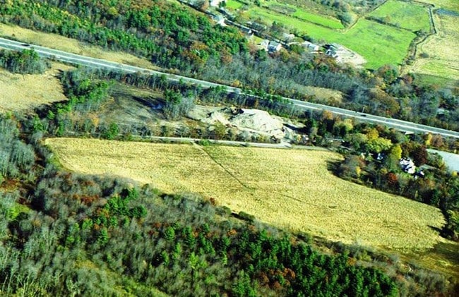
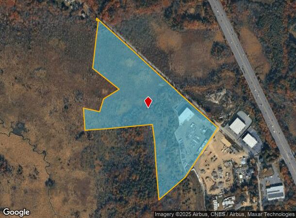
Property Record
252 Pleasant St, West Bridgewater, MA 02379
NEARBY LISTINGS FOR SALE OR LEASE
Property Detail
252 Pleasant St
WBRI-000057-000000-000020
Plymouth
Warehouse
Massachusetts
AE
20
25023C0168J
30.71 AC
2025
Route 3 South
2025
Boston
524101
Boston-Cambridge-Newton, MA-NH
15,494 SF
DEMOGRAPHICS near 252 Pleasant St
1 Mile
3 Mile
5 Mile
2024 Total Population
738
14,861
86,623
2029 Population
740
14,920
86,161
Pop Growth 2024-2029
+ 0.27%
+ 0.40%
(0.53%)
Average Age
40
42
40
2024 Total Households
259
5,608
29,772
HH Growth 2024-2029
+ 0.39%
+ 0.34%
(0.55%)
Median Household Inc
$108,181
$102,875
$99,524
Avg Household Size
2.80
2.60
2.70
2024 Avg HH Vehicles
2.00
2.00
2.00
Median Home Value
$486,764
$450,316
$437,946
Median Year Built
1955
1973
1970
Nearby Places
- Restaurants
- Banks
- Shops
- Fitness
- Groceries
PUBLIC TRANSPORTATION
COMMUTER RAIL
Campello (Middleborough/Lakeville Line - Massachusetts Bay Transportation Authority Commuter Rail (Purple Line))
DRIVE
WALK
Distance
Campello (Middleborough/Lakeville Line - Massachusetts Bay Transportation Authority Commuter Rail (Purple Line))
11 min
5.4 mi
Bridgewater (Middleborough/Lakeville Line - Massachusetts Bay Transportation Authority Commuter Rail (Purple Line))
DRIVE
WALK
Distance
Bridgewater (Middleborough/Lakeville Line - Massachusetts Bay Transportation Authority Commuter Rail (Purple Line))
14 min
6.4 mi
AIRPORT
General Edward Lawrence Logan International
DRIVE
WALK
Distance
General Edward Lawrence Logan International
43 min
30.6 mi
Rhode Island Tf Green International
DRIVE
WALK
Distance
Rhode Island Tf Green International
60 min
36.7 mi
Freight Ports
Port of Boston
DRIVE
WALK
Distance
Port of Boston
40 min
28.4 mi
Nearby Properties
Address
Land Use
TOTAL SIZE
Lot Size
Zoning
Address
Land Use
TOTAL SIZE
Lot Size
Zoning
43.60 AC
Address
Land Use
TOTAL SIZE
Lot Size
Zoning
349,800 SF
30.82 AC
Address
Land Use
TOTAL SIZE
Lot Size
Zoning
0.78 AC
Address
Land Use
TOTAL SIZE
Lot Size
Zoning
216,489 SF
49.60 AC
Address
Land Use
TOTAL SIZE
Lot Size
Zoning
21.12 AC
Address
Land Use
TOTAL SIZE
Lot Size
Zoning
109,960 SF
28.02 AC
Address
Land Use
TOTAL SIZE
Lot Size
Zoning
558,011 SF
82.11 AC
Address
Land Use
TOTAL SIZE
Lot Size
Zoning
67.01 AC
Address
Land Use
TOTAL SIZE
Lot Size
Zoning
104,207 SF
27.78 AC
Address
Land Use
TOTAL SIZE
Lot Size
Zoning
312,000 SF
30.61 AC
Address
Land Use
TOTAL SIZE
Lot Size
Zoning
Address
Land Use
TOTAL SIZE
Lot Size
Zoning
211,030 SF
19.27 AC
Address
Land Use
TOTAL SIZE
Lot Size
Zoning
80,429 SF
16.68 AC
Address
Land Use
TOTAL SIZE
Lot Size
Zoning
101,871 SF
82.25 AC
Address
Land Use
TOTAL SIZE
Lot Size
Zoning
79,144 SF
5.30 AC
Address
Land Use
TOTAL SIZE
Lot Size
Zoning
44,138 SF
27.41 AC
Address
Land Use
TOTAL SIZE
Lot Size
Zoning
90,920 SF
6.27 AC
Address
Land Use
TOTAL SIZE
Lot Size
Zoning
80,225 SF
8.07 AC
Address
Land Use
TOTAL SIZE
Lot Size
Zoning
Address
Land Use
TOTAL SIZE
Lot Size
Zoning
15.90 AC
Address
Land Use
TOTAL SIZE
Lot Size
Zoning
88,200 SF
8.98 AC
Address
Land Use
TOTAL SIZE
Lot Size
Zoning
128,963 SF
83.17 AC
Address
Land Use
TOTAL SIZE
Lot Size
Zoning
68,700 SF
19 AC
Address
Land Use
TOTAL SIZE
Lot Size
Zoning
12,396 SF
4.66 AC
Address
Land Use
TOTAL SIZE
Lot Size
Zoning
144,604 SF
25.03 AC
Address
Land Use
TOTAL SIZE
Lot Size
Zoning
102,008 SF
11.22 AC
Address
Land Use
TOTAL SIZE
Lot Size
Zoning
40,000 SF
9.27 AC
Address
Land Use
TOTAL SIZE
Lot Size
Zoning
56,354 SF
7.26 AC
Address
Land Use
TOTAL SIZE
Lot Size
Zoning
52,500 SF
5.88 AC
Address
Land Use
TOTAL SIZE
Lot Size
Zoning
108,270 SF
11.95 AC
The World's #1 Commercial Real Estate Marketplace
Connect with us
© 2025 CoStar Group
The information above has been obtained from sources believed reliable. While we do not doubt its accuracy we have not verified it and make no guarantee, warranty or representation about it. It is your responsibility to independently confirm its accuracy and completeness. Any projections, opinions, assumptions, or estimates used are for example only and do not represent the current or future performance of the property. The value of this transaction to you depends on tax and other factors which should be evaluated by your tax, financial, and legal advisors. You and your advisors should conduct a careful, independent investigation of the property to determine to your satisfaction the suitability of the property for your needs.