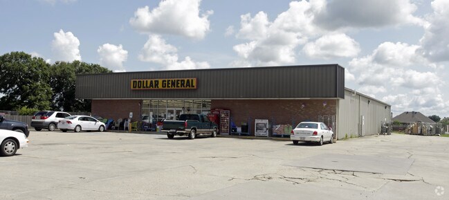
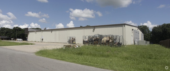
Property Record
254 Rees St, Breaux Bridge, LA 70517

Save to a Folder
{{folder.Name}}
{{folder.ListingIds.length}} Properties
{{folder.ListingIds.length}} Property
Create a New Folder
Property Detail
254 Rees St
Lafayette, LA
LOT 123.03 X 299.98 LATIOLAIS, BREAUX BRIDGE PROPERTIES INC., SOUTH BELLE CIRCLE, REES ST.COB 1296-524-301815 1369-242-341016
06901G1329
Saint Martin
Commercialnec
Louisiana
2025
0.85 AC
2025
St Martin Parish
020502
Lafayette
10,250 SF
NEARBY LISTINGS FOR SALE OR LEASE
-
-
View all Breaux Bridge listings for sale on LoopNet.com
DEMOGRAPHICS near 254 Rees St
1 mile
3 mile
5 mile
2025 Total Population
5,338
12,578
22,823
2030 Population
5,326
12,509
22,727
Pop Growth 2025-2030
(0.22%)
(0.55%)
(0.42%)
Average Age
38
39
39
2025 Total Households
2,112
4,907
8,817
HH Growth 2025-2030
(0.09%)
(0.47%)
(0.39%)
Median Household Inc
$43,711
$51,444
$58,882
Avg Household Size
2.40
2.50
2.50
2025 Avg HH Vehicles
2.00
2.00
2.00
Median Home Value
$178,425
$184,738
$175,012
Median Year Built
1976
1985
1987
Nearby Places
Map Layers
Map Styles
 Street
 Aerial
Layers
 Traffic
 Biking
Places
Listings with unknown addresses are not visible on the map
- Restaurants
- Banks
- Shops
- Fitness
- Groceries
PUBLIC TRANSPORTATION
AIRPORT
Lafayette Regional/Paul Fournet Field
Drive
Walk
Distance
Lafayette Regional/Paul Fournet Field
18 min
9.1 mi
Freight Ports
Port of Iberia
Drive
Walk
Distance
Port of Iberia
45 min
31.3 mi
Nearby Properties
Address
Land Use
TOTAL SIZE
Lot Size
Zoning
Address
Land Use
TOTAL SIZE
Lot Size
Zoning
180,130 SF
22.92 AC
Address
Land Use
TOTAL SIZE
Lot Size
Zoning
Address
Land Use
TOTAL SIZE
Lot Size
Zoning
29,942 SF
41.67 AC
Address
Land Use
TOTAL SIZE
Lot Size
Zoning
Address
Land Use
TOTAL SIZE
Lot Size
Zoning
9,000 SF
10.80 AC
Address
Land Use
TOTAL SIZE
Lot Size
Zoning
12,000 SF
11.29 AC
Address
Land Use
TOTAL SIZE
Lot Size
Zoning
43,242 SF
9.60 AC
Address
Land Use
TOTAL SIZE
Lot Size
Zoning
4,000 SF
11.41 AC
Address
Land Use
TOTAL SIZE
Lot Size
Zoning
30,900 SF
3.18 AC
Address
Land Use
TOTAL SIZE
Lot Size
Zoning
41,334 SF
6.34 AC
Address
Land Use
TOTAL SIZE
Lot Size
Zoning
12,047 SF
2.41 AC
Address
Land Use
TOTAL SIZE
Lot Size
Zoning
44,026 SF
5.06 AC
Address
Land Use
TOTAL SIZE
Lot Size
Zoning
15,540 SF
7.78 AC
Address
Land Use
TOTAL SIZE
Lot Size
Zoning
38,656 SF
6 AC
Address
Land Use
TOTAL SIZE
Lot Size
Zoning
Address
Land Use
TOTAL SIZE
Lot Size
Zoning
8,180 SF
2.57 AC
Address
Land Use
TOTAL SIZE
Lot Size
Zoning
2,485 SF
4.83 AC
Address
Land Use
TOTAL SIZE
Lot Size
Zoning
Address
Land Use
TOTAL SIZE
Lot Size
Zoning
2,577 SF
0.30 AC
Address
Land Use
TOTAL SIZE
Lot Size
Zoning
1,895 SF
0.64 AC
Address
Land Use
TOTAL SIZE
Lot Size
Zoning
10,194 SF
2.81 AC
Address
Land Use
TOTAL SIZE
Lot Size
Zoning
2,260 SF
0.66 AC
Address
Land Use
TOTAL SIZE
Lot Size
Zoning
1,951 SF
1.51 AC
Address
Land Use
TOTAL SIZE
Lot Size
Zoning
120,000 SF
18.99 AC
Address
Land Use
TOTAL SIZE
Lot Size
Zoning
7,098 SF
6.26 AC
Address
Land Use
TOTAL SIZE
Lot Size
Zoning
30,000 SF
7.56 AC
Address
Land Use
TOTAL SIZE
Lot Size
Zoning
2,844 SF
Address
Land Use
TOTAL SIZE
Lot Size
Zoning
14,178 SF
1.64 AC
Address
Land Use
TOTAL SIZE
Lot Size
Zoning
14,719 SF
1.69 AC
Address
Land Use
TOTAL SIZE
Lot Size
Zoning
1,100 SF
0.28 AC
The World's #1 Commercial Real Estate Marketplace
Connect with us
© 2026 CoStar Group
The information above has been obtained from sources believed reliable. While we do not doubt its accuracy we have not verified it and make no guarantee, warranty or representation about it. It is your responsibility to independently confirm its accuracy and completeness. Any projections, opinions, assumptions, or estimates used are for example only and do not represent the current or future performance of the property. The value of this transaction to you depends on tax and other factors which should be evaluated by your tax, financial, and legal advisors. You and your advisors should conduct a careful, independent investigation of the property to determine to your satisfaction the suitability of the property for your needs.