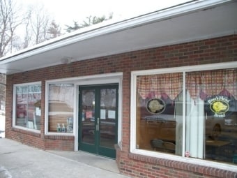
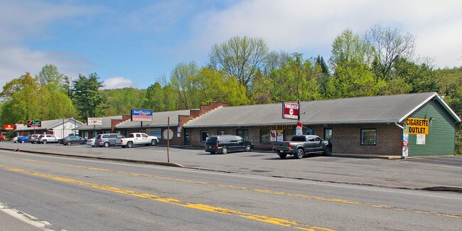
Property Record
2541 Route 611, Scotrun, PA 18355
NEARBY LISTINGS FOR SALE OR LEASE
-
-
-
-
No Photo
-
-
View all Scotrun listings for sale on LoopNet.com
Property Detail
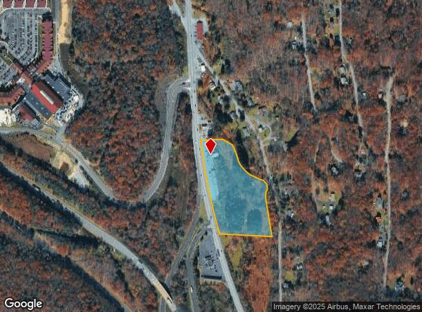
2541 Route 611
12.6.1.66
SCOTRUN PLAZA
Storebuilding
Monroe
AE
Pennsylvania
42089C0262E
8.16 AC
2025
Monroe County
2025
Philadelphia
300401
East Stroudsburg, PA
6,300 SF
DEMOGRAPHICS near 2541 Route 611
1 Mile
3 Mile
5 Mile
2024 Total Population
583
8,587
23,644
2029 Population
580
8,514
23,541
Pop Growth 2024-2029
(0.51%)
(0.85%)
(0.44%)
Average Age
44
44
43
2024 Total Households
234
3,324
8,747
HH Growth 2024-2029
(0.43%)
(0.84%)
(0.50%)
Median Household Inc
$107,812
$101,349
$90,514
Avg Household Size
2.50
2.50
2.60
2024 Avg HH Vehicles
2.00
2.00
2.00
Median Home Value
$234,091
$233,073
$232,880
Median Year Built
1977
1980
1984
Nearby Places
Map Layers
Map Styles
 Street
 Aerial
- Restaurants
- Banks
- Shops
- Fitness
- Groceries
PUBLIC TRANSPORTATION
AIRPORT
Lehigh Valley International
DRIVE
WALK
Distance
Lehigh Valley International
52 min
34.4 mi
Wilkes-Barre/Scranton International
DRIVE
WALK
Distance
Wilkes-Barre/Scranton International
55 min
44.5 mi
Freight Ports
Maher Terminal
DRIVE
WALK
Distance
Maher Terminal
101 min
79.5 mi
SALE & LEASE HISTORY
LISTING DATE
SALE/LEASE

Jun 06, 2018
For Sale
Nearby Properties
Address
Land Use
TOTAL SIZE
Lot Size
Zoning
Address
Land Use
TOTAL SIZE
Lot Size
Zoning
463,854 SF
95.86 AC
C
Address
Land Use
TOTAL SIZE
Lot Size
Zoning
1,132 SF
212.87 AC
I
Address
Land Use
TOTAL SIZE
Lot Size
Zoning
64,000 SF
23.31 AC
C
Address
Land Use
TOTAL SIZE
Lot Size
Zoning
124,288 SF
10.58 AC
C
Address
Land Use
TOTAL SIZE
Lot Size
Zoning
40,418 SF
78.43 AC
C
Address
Land Use
TOTAL SIZE
Lot Size
Zoning
1,024 SF
147.49 AC
RD
Address
Land Use
TOTAL SIZE
Lot Size
Zoning
57,088 SF
58.47 AC
C
Address
Land Use
TOTAL SIZE
Lot Size
Zoning
72,386 SF
19.74 AC
C
Address
Land Use
TOTAL SIZE
Lot Size
Zoning
79,200 SF
67.68 AC
C
Address
Land Use
TOTAL SIZE
Lot Size
Zoning
40,320 SF
17.79 AC
C
Address
Land Use
TOTAL SIZE
Lot Size
Zoning
103,185 SF
39.71 AC
C
Address
Land Use
TOTAL SIZE
Lot Size
Zoning
36,626 SF
10.26 AC
R1
Address
Land Use
TOTAL SIZE
Lot Size
Zoning
38,158 SF
9.95 AC
C
Address
Land Use
TOTAL SIZE
Lot Size
Zoning
48,622 SF
2.47 AC
C
Address
Land Use
TOTAL SIZE
Lot Size
Zoning
9,450 SF
159 AC
R-1
Address
Land Use
TOTAL SIZE
Lot Size
Zoning
78,842 SF
7.24 AC
RD
Address
Land Use
TOTAL SIZE
Lot Size
Zoning
27,614 SF
36.14 AC
C
Address
Land Use
TOTAL SIZE
Lot Size
Zoning
5,952 SF
21.50 AC
C
Address
Land Use
TOTAL SIZE
Lot Size
Zoning
51,060 SF
7 AC
C
Address
Land Use
TOTAL SIZE
Lot Size
Zoning
7,488 SF
5.74 AC
C
Address
Land Use
TOTAL SIZE
Lot Size
Zoning
1,212 SF
1 AC
C
Address
Land Use
TOTAL SIZE
Lot Size
Zoning
62,147 SF
39.87 AC
C
Address
Land Use
TOTAL SIZE
Lot Size
Zoning
4,106 SF
4.32 AC
C
Address
Land Use
TOTAL SIZE
Lot Size
Zoning
21,900 SF
6.11 AC
R-1
Address
Land Use
TOTAL SIZE
Lot Size
Zoning
2,000 SF
55.50 AC
I
Address
Land Use
TOTAL SIZE
Lot Size
Zoning
25,214 SF
11.39 AC
C
Address
Land Use
TOTAL SIZE
Lot Size
Zoning
19,840 SF
3.98 AC
C
Address
Land Use
TOTAL SIZE
Lot Size
Zoning
19,634 SF
10.20 AC
RC
Address
Land Use
TOTAL SIZE
Lot Size
Zoning
5,932 SF
2.47 AC
C
Address
Land Use
TOTAL SIZE
Lot Size
Zoning
9,184 SF
5.20 AC
C
The World's #1 Commercial Real Estate Marketplace
Connect with us
© 2025 CoStar Group
The information above has been obtained from sources believed reliable. While we do not doubt its accuracy we have not verified it and make no guarantee, warranty or representation about it. It is your responsibility to independently confirm its accuracy and completeness. Any projections, opinions, assumptions, or estimates used are for example only and do not represent the current or future performance of the property. The value of this transaction to you depends on tax and other factors which should be evaluated by your tax, financial, and legal advisors. You and your advisors should conduct a careful, independent investigation of the property to determine to your satisfaction the suitability of the property for your needs.