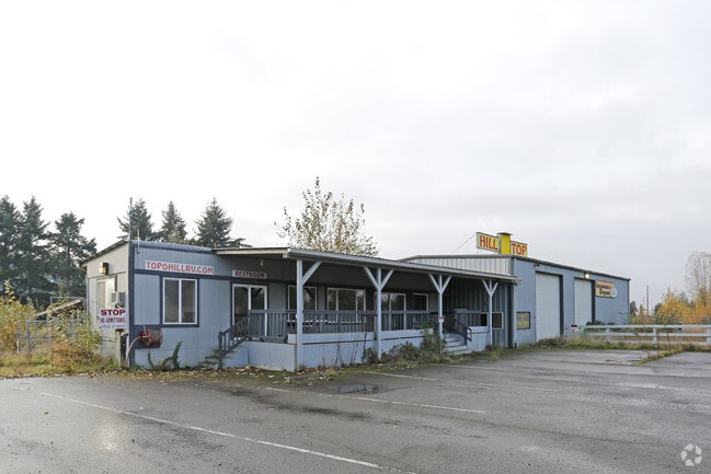
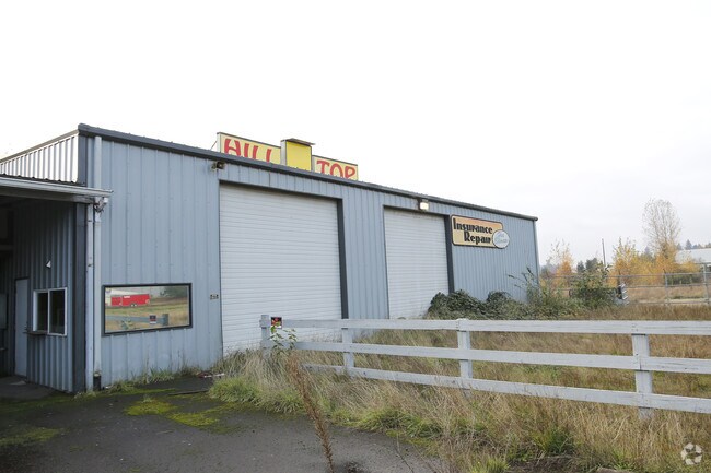
Property Record
25420 S Highway 99E, Aurora, OR 97002


Property Detail
25420 S Highway 99E
01004905
SECTION 07 TOWNSHIP 4S RANGE 1E TAX LOT 00800
Industrialgeneral
Clackamas
EFU
Oregon
B and X Area of moderate flood hazard, usually the area between the limits of the 100-year and 500-year floods.
800
2025
4.03 AC
2025
SE Outlying
022800
Portland
1,518 SF
Portland-Vancouver-Hillsboro, OR-WA
NEARBY LISTINGS FOR SALE OR LEASE
-
-
View all Aurora listings for sale on LoopNet.com
DEMOGRAPHICS near 25420 S Highway 99E
1 mile
3 mile
5 mile
2025 Total Population
220
13,827
41,534
2030 Population
212
13,872
41,829
Pop Growth 2025-2030
(3.64%)
+ 0.33%
+ 0.71%
Average Age
43
43
43
2025 Total Households
79
5,064
15,814
HH Growth 2025-2030
(3.80%)
+ 0.43%
+ 0.73%
Median Household Inc
$55,000
$86,610
$94,240
Avg Household Size
2.80
2.70
2.60
2025 Avg HH Vehicles
2.00
2.00
2.00
Median Home Value
$274,999
$481,417
$581,128
Median Year Built
1984
1988
1989
Nearby Places
Map Layers
Map Styles
 Street
 Aerial
Layers
 Traffic
 Biking
Places
Listings with unknown addresses are not visible on the map
- Restaurants
- Banks
- Shops
- Fitness
- Groceries
PUBLIC TRANSPORTATION
COMMUTER RAIL
Wilsonville (Westside Express Service - Tri-County Metropolitan Transportation District of Oregon Rail (TriMet Rail))
Drive
Walk
Distance
Wilsonville (Westside Express Service - Tri-County Metropolitan Transportation District of Oregon Rail (TriMet Rail))
14 min
7.6 mi
AIRPORT
Portland International
Drive
Walk
Distance
Portland International
47 min
30.3 mi
Freight Ports
Port of Portland
Drive
Walk
Distance
Port of Portland
38 min
26.4 mi
Nearby Properties
Address
Land Use
TOTAL SIZE
Lot Size
Zoning
Address
Land Use
TOTAL SIZE
Lot Size
Zoning
165,375 SF
27.47 AC
P-LU
Address
Land Use
TOTAL SIZE
Lot Size
Zoning
Address
Land Use
TOTAL SIZE
Lot Size
Zoning
19.24 AC
P
Address
Land Use
TOTAL SIZE
Lot Size
Zoning
4.88 AC
R1.5
Address
Land Use
TOTAL SIZE
Lot Size
Zoning
Address
Land Use
TOTAL SIZE
Lot Size
Zoning
1 SF
7 AC
C2
Address
Land Use
TOTAL SIZE
Lot Size
Zoning
828 SF
0.74 AC
C1
Address
Land Use
TOTAL SIZE
Lot Size
Zoning
13.91 AC
M1
Address
Land Use
TOTAL SIZE
Lot Size
Zoning
4.53 AC
P
Address
Land Use
TOTAL SIZE
Lot Size
Zoning
Address
Land Use
TOTAL SIZE
Lot Size
Zoning
42,972 SF
0.99 AC
P
Address
Land Use
TOTAL SIZE
Lot Size
Zoning
5.84 AC
Address
Land Use
TOTAL SIZE
Lot Size
Zoning
7.95 AC
R2
Address
Land Use
TOTAL SIZE
Lot Size
Zoning
Address
Land Use
TOTAL SIZE
Lot Size
Zoning
16.26 AC
M1
Address
Land Use
TOTAL SIZE
Lot Size
Zoning
20 SF
0.73 AC
P
Address
Land Use
TOTAL SIZE
Lot Size
Zoning
6.66 AC
M1
Address
Land Use
TOTAL SIZE
Lot Size
Zoning
20 SF
0.48 AC
P
Address
Land Use
TOTAL SIZE
Lot Size
Zoning
1.39 AC
CM
Address
Land Use
TOTAL SIZE
Lot Size
Zoning
36,810 SF
0.78 AC
P
Address
Land Use
TOTAL SIZE
Lot Size
Zoning
1 SF
1.24 AC
C1
Address
Land Use
TOTAL SIZE
Lot Size
Zoning
30,612 SF
0.71 AC
P
Address
Land Use
TOTAL SIZE
Lot Size
Zoning
3.16 AC
M1
Address
Land Use
TOTAL SIZE
Lot Size
Zoning
171.47 AC
EFU
Address
Land Use
TOTAL SIZE
Lot Size
Zoning
6.82 AC
CM
Address
Land Use
TOTAL SIZE
Lot Size
Zoning
26,010 SF
0.60 AC
P
Address
Land Use
TOTAL SIZE
Lot Size
Zoning
Address
Land Use
TOTAL SIZE
Lot Size
Zoning
0.67 AC
CM
Address
Land Use
TOTAL SIZE
Lot Size
Zoning
4.59 AC
M1
The World's #1 Commercial Real Estate Marketplace
Connect with us
© 2026 CoStar Group
The information above has been obtained from sources believed reliable. While we do not doubt its accuracy we have not verified it and make no guarantee, warranty or representation about it. It is your responsibility to independently confirm its accuracy and completeness. Any projections, opinions, assumptions, or estimates used are for example only and do not represent the current or future performance of the property. The value of this transaction to you depends on tax and other factors which should be evaluated by your tax, financial, and legal advisors. You and your advisors should conduct a careful, independent investigation of the property to determine to your satisfaction the suitability of the property for your needs.