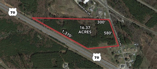
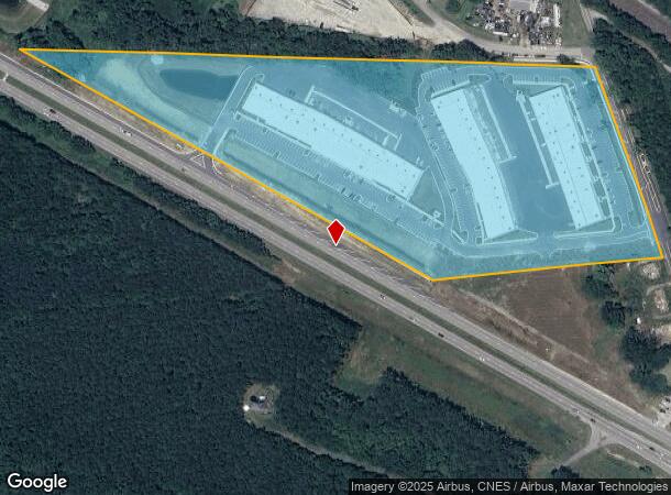
Property Record
2545 Us 70 Hwy E, Garner, NC 27529
NEARBY LISTINGS FOR SALE OR LEASE
Property Detail
2545 Us 70 Hwy E
1740.03-12-2349-000
Garner Property Qozb Llc
Warehouse
GARNER PROPERTY QOZB LLC R/W DEDI BM2023
X
Wake
3720174000J
North Carolina
2024
16.44 AC
2025
Southeast Wake County
052807
Raleigh/Durham
127,932 SF
Raleigh, NC
DEMOGRAPHICS near 2545 Us 70 Hwy E
1 Mile
3 Mile
5 Mile
2024 Total Population
689
15,242
66,616
2029 Population
750
17,483
76,902
Pop Growth 2024-2029
+ 8.85%
+ 14.70%
+ 15.44%
Average Age
39
39
38
2024 Total Households
257
6,051
25,053
HH Growth 2024-2029
+ 8.95%
+ 14.76%
+ 15.80%
Median Household Inc
$85,049
$78,957
$71,940
Avg Household Size
2.60
2.50
2.60
2024 Avg HH Vehicles
2.00
2.00
2.00
Median Home Value
$279,629
$288,117
$264,497
Median Year Built
2000
2002
2002
Nearby Places
- Restaurants
- Banks
- Shops
- Fitness
- Groceries
PUBLIC TRANSPORTATION
AIRPORT
Raleigh-Durham International
DRIVE
WALK
Distance
Raleigh-Durham International
35 min
26.3 mi
Freight Ports
Port of Wilmington
DRIVE
WALK
Distance
Port of Wilmington
146 min
127.9 mi
SALE & LEASE HISTORY
LISTING DATE
SALE/LEASE

Sep 24, 2016
For Sale
Nearby Properties
Address
Land Use
TOTAL SIZE
Lot Size
Zoning
Address
Land Use
TOTAL SIZE
Lot Size
Zoning
141,020 SF
1,462.55 AC
R-30
Address
Land Use
TOTAL SIZE
Lot Size
Zoning
390,672 SF
30.23 AC
CMX
Address
Land Use
TOTAL SIZE
Lot Size
Zoning
288,761 SF
19.61 AC
MF-B
Address
Land Use
TOTAL SIZE
Lot Size
Zoning
298,563 SF
24.19 AC
CMX
Address
Land Use
TOTAL SIZE
Lot Size
Zoning
5,616 SF
22.46 AC
PUD
Address
Land Use
TOTAL SIZE
Lot Size
Zoning
279,123 SF
22.91 AC
CMX
Address
Land Use
TOTAL SIZE
Lot Size
Zoning
304,813 SF
19.08 AC
MF-A
Address
Land Use
TOTAL SIZE
Lot Size
Zoning
250,558 SF
23.49 AC
CMX
Address
Land Use
TOTAL SIZE
Lot Size
Zoning
691,230 SF
106.53 AC
IND
Address
Land Use
TOTAL SIZE
Lot Size
Zoning
225,000 SF
22.47 AC
HI
Address
Land Use
TOTAL SIZE
Lot Size
Zoning
298,354 SF
36.16 AC
IND
Address
Land Use
TOTAL SIZE
Lot Size
Zoning
118,430 SF
24.82 AC
IND
Address
Land Use
TOTAL SIZE
Lot Size
Zoning
240,000 SF
15.55 AC
LI
Address
Land Use
TOTAL SIZE
Lot Size
Zoning
2,527 SF
173.31 AC
CMX
Address
Land Use
TOTAL SIZE
Lot Size
Zoning
166,413 SF
12.47 AC
HI
Address
Land Use
TOTAL SIZE
Lot Size
Zoning
78,409 SF
45.91 AC
RA
Address
Land Use
TOTAL SIZE
Lot Size
Zoning
180,000 SF
10.77 AC
LI
Address
Land Use
TOTAL SIZE
Lot Size
Zoning
150,662 SF
10.25 AC
HI
Address
Land Use
TOTAL SIZE
Lot Size
Zoning
160,380 SF
12.25 AC
LI
Address
Land Use
TOTAL SIZE
Lot Size
Zoning
201,003 SF
21.64 AC
SUP
Address
Land Use
TOTAL SIZE
Lot Size
Zoning
129,311 SF
6.89 AC
HI
Address
Land Use
TOTAL SIZE
Lot Size
Zoning
197,238 SF
63.71 AC
LI
Address
Land Use
TOTAL SIZE
Lot Size
Zoning
133,000 SF
6.89 AC
HI
Address
Land Use
TOTAL SIZE
Lot Size
Zoning
2,664 SF
448.85 AC
COM
Address
Land Use
TOTAL SIZE
Lot Size
Zoning
168,858 SF
10.21 AC
LI
Address
Land Use
TOTAL SIZE
Lot Size
Zoning
6,010 SF
304.87 AC
R-4
Address
Land Use
TOTAL SIZE
Lot Size
Zoning
122,003 SF
7.15 AC
HI
Address
Land Use
TOTAL SIZE
Lot Size
Zoning
98,010 SF
11.77 AC
LI
Address
Land Use
TOTAL SIZE
Lot Size
Zoning
150,000 SF
13.25 AC
LI
The World's #1 Commercial Real Estate Marketplace
Connect with us
© 2025 CoStar Group
The information above has been obtained from sources believed reliable. While we do not doubt its accuracy we have not verified it and make no guarantee, warranty or representation about it. It is your responsibility to independently confirm its accuracy and completeness. Any projections, opinions, assumptions, or estimates used are for example only and do not represent the current or future performance of the property. The value of this transaction to you depends on tax and other factors which should be evaluated by your tax, financial, and legal advisors. You and your advisors should conduct a careful, independent investigation of the property to determine to your satisfaction the suitability of the property for your needs.