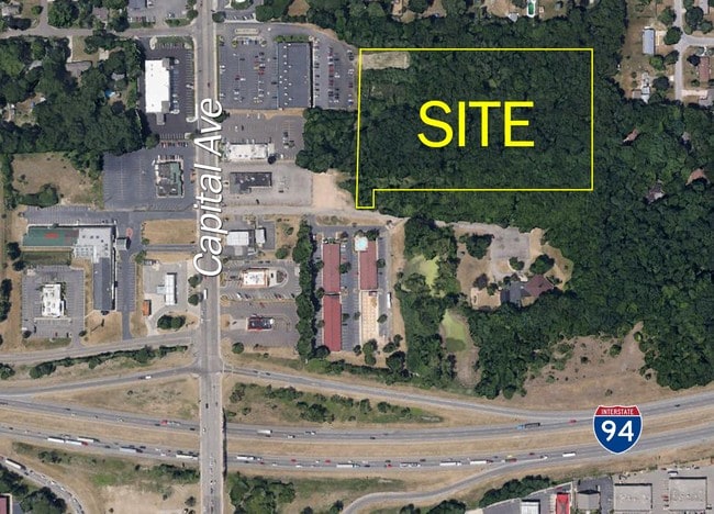
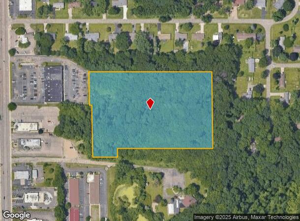
Property Record
Sw Capital Ave, Battle Creek, MI 49015
Current Lease Availabilities
NEARBY LISTINGS FOR SALE OR LEASE
Property Detail
Sw Capital Ave
0075-00-390-0
SEC 25 T2S R8W COMM ON W SEC LI AT PT DIST N 00 DEG 12 MIN 00 SEC E 102 FT FROM NW COR OF SW 1/4 OF
Commercialacreage
Calhoun
X
Michigan
26025C0189C
7.60 AC
0
Battle Crk/W Calhoun Cnty
2025
West Michigan
001500
Battle Creek, MI
DEMOGRAPHICS near Sw Capital Ave
1 Mile
3 Mile
5 Mile
2024 Total Population
5,424
24,885
57,633
2029 Population
5,348
24,497
57,094
Pop Growth 2024-2029
(1.40%)
(1.56%)
(0.94%)
Average Age
39
41
39
2024 Total Households
2,369
10,295
23,235
HH Growth 2024-2029
(1.18%)
(1.46%)
(0.94%)
Median Household Inc
$60,375
$70,286
$54,033
Avg Household Size
2.20
2.30
2.40
2024 Avg HH Vehicles
2.00
2.00
2.00
Median Home Value
$184,830
$175,756
$131,903
Median Year Built
1978
1966
1958
Nearby Places
- Restaurants
- Banks
- Shops
- Fitness
- Groceries
PUBLIC TRANSPORTATION
COMMUTER RAIL
Battle Creek (Blue Water - Amtrak, Wolverine - Amtrak)
DRIVE
WALK
Distance
Battle Creek (Blue Water - Amtrak, Wolverine - Amtrak)
9 min
5.9 mi
AIRPORT
Kalamazoo/Battle Creek International
DRIVE
WALK
Distance
Kalamazoo/Battle Creek International
30 min
21.4 mi
Freight Ports
Port of Toledo
DRIVE
WALK
Distance
Port of Toledo
152 min
124.0 mi
Nearby Properties
Address
Land Use
TOTAL SIZE
Lot Size
Zoning
Address
Land Use
TOTAL SIZE
Lot Size
Zoning
214,023 SF
35.60 AC
MFR
Address
Land Use
TOTAL SIZE
Lot Size
Zoning
205,436 SF
9.88 AC
MFR
Address
Land Use
TOTAL SIZE
Lot Size
Zoning
158,242 SF
28.01 AC
B1
Address
Land Use
TOTAL SIZE
Lot Size
Zoning
69,435 SF
24.84 AC
MFR
Address
Land Use
TOTAL SIZE
Lot Size
Zoning
63,180 SF
3.55 AC
RC
Address
Land Use
TOTAL SIZE
Lot Size
Zoning
135,286 SF
21.86 AC
MFR
Address
Land Use
TOTAL SIZE
Lot Size
Zoning
270,000 SF
24.29 AC
I2
Address
Land Use
TOTAL SIZE
Lot Size
Zoning
309,945 SF
25.02 AC
MFR
Address
Land Use
TOTAL SIZE
Lot Size
Zoning
131,048 SF
12.28 AC
R1A
Address
Land Use
TOTAL SIZE
Lot Size
Zoning
79,074 SF
4.98 AC
RC
Address
Land Use
TOTAL SIZE
Lot Size
Zoning
221,522 SF
23.23 AC
RC
Address
Land Use
TOTAL SIZE
Lot Size
Zoning
196,120 SF
21.42 AC
RC
Address
Land Use
TOTAL SIZE
Lot Size
Zoning
134,482 SF
17.15 AC
MFR
Address
Land Use
TOTAL SIZE
Lot Size
Zoning
158,242 SF
25.25 AC
B1
Address
Land Use
TOTAL SIZE
Lot Size
Zoning
252,000 SF
34.57 AC
I2
Address
Land Use
TOTAL SIZE
Lot Size
Zoning
134,355 SF
5.35 AC
MFR
Address
Land Use
TOTAL SIZE
Lot Size
Zoning
137,827 SF
20.09 AC
B2
Address
Land Use
TOTAL SIZE
Lot Size
Zoning
192,680 SF
21.66 AC
RC
Address
Land Use
TOTAL SIZE
Lot Size
Zoning
63,180 SF
12.12 AC
RC
Address
Land Use
TOTAL SIZE
Lot Size
Zoning
81,376 SF
7.82 AC
MFR
Address
Land Use
TOTAL SIZE
Lot Size
Zoning
65,773 SF
2.42 AC
RC
Address
Land Use
TOTAL SIZE
Lot Size
Zoning
56,349 SF
7.54 AC
RC
Address
Land Use
TOTAL SIZE
Lot Size
Zoning
66,096 SF
9.71 AC
MFR
Address
Land Use
TOTAL SIZE
Lot Size
Zoning
124,141 SF
21.18 AC
RC
Address
Land Use
TOTAL SIZE
Lot Size
Zoning
81,857 SF
9.29 AC
RC
Address
Land Use
TOTAL SIZE
Lot Size
Zoning
366,290 SF
31.87 AC
B2
Address
Land Use
TOTAL SIZE
Lot Size
Zoning
44,034 SF
1.60 AC
RC
Address
Land Use
TOTAL SIZE
Lot Size
Zoning
72,260 SF
12.33 AC
B2
Address
Land Use
TOTAL SIZE
Lot Size
Zoning
78,000 SF
8.21 AC
MFR
Address
Land Use
TOTAL SIZE
Lot Size
Zoning
79,457 SF
8.60 AC
MFR
The World's #1 Commercial Real Estate Marketplace
Connect with us
© 2025 CoStar Group
The information above has been obtained from sources believed reliable. While we do not doubt its accuracy we have not verified it and make no guarantee, warranty or representation about it. It is your responsibility to independently confirm its accuracy and completeness. Any projections, opinions, assumptions, or estimates used are for example only and do not represent the current or future performance of the property. The value of this transaction to you depends on tax and other factors which should be evaluated by your tax, financial, and legal advisors. You and your advisors should conduct a careful, independent investigation of the property to determine to your satisfaction the suitability of the property for your needs.