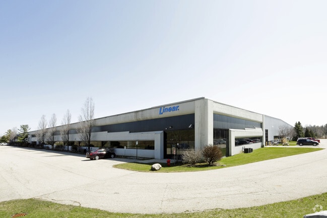
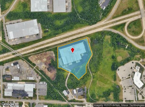
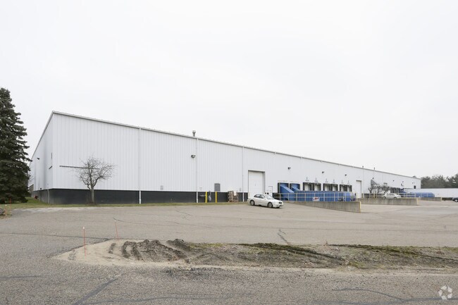
Property Record
2547 3 Mile Rd Nw, Grand Rapids, MI 49534
NEARBY LISTINGS FOR SALE OR LEASE
-
-
-
No Photo
-
-
-
-
-
View all Grand Rapids listings for lease on LoopNet.com
Property Detail
2547 3 Mile Rd Nw
41-13-04-400-039
411304400039 PART OF SE 1/4 COM AT SE COR OF SEC TH N 87D 48M 42S W ALONG S SEC LINE 684.80 FT TO E LINE OF W 1/2 E 1/2 SE
Warehouse
Kent
AE
Michigan
26081C0288D
12.79 AC
2024
W Grand Rapids/Walker
2025
West Michigan
011601
Grand Rapids-Wyoming, MI
206,250 SF
DEMOGRAPHICS near 2547 3 Mile Rd Nw
1 Mile
3 Mile
5 Mile
2024 Total Population
1,514
36,949
114,812
2029 Population
1,493
37,030
115,632
Pop Growth 2024-2029
(1.39%)
+ 0.22%
+ 0.71%
Average Age
39
39
38
2024 Total Households
638
15,504
48,632
HH Growth 2024-2029
(1.41%)
+ 0.26%
+ 0.77%
Median Household Inc
$68,650
$66,558
$64,666
Avg Household Size
2.30
2.30
2.30
2024 Avg HH Vehicles
2.00
2.00
2.00
Median Home Value
$305,839
$232,217
$219,409
Median Year Built
1990
1975
1965
Nearby Places
Map Layers
Map Styles
 Street
 Aerial
- Restaurants
- Banks
- Shops
- Fitness
- Groceries
PUBLIC TRANSPORTATION
AIRPORT
Gerald R Ford International
DRIVE
WALK
Distance
Gerald R Ford International
21 min
18.8 mi
Freight Ports
Port of Baltimore
DRIVE
WALK
Distance
Port of Baltimore
1 min
541.1 mi
SALE & LEASE HISTORY
LISTING DATE
SALE/LEASE

Sep 24, 2016
For Lease
Jul 26, 2019
For Lease
Nearby Properties
Address
Land Use
TOTAL SIZE
Lot Size
Zoning
Address
Land Use
TOTAL SIZE
Lot Size
Zoning
537,080 SF
46.61 AC
RPUD - 2
Address
Land Use
TOTAL SIZE
Lot Size
Zoning
352,362 SF
61.33 AC
IPUD
Address
Land Use
TOTAL SIZE
Lot Size
Zoning
546,366 SF
28.40 AC
MH
Address
Land Use
TOTAL SIZE
Lot Size
Zoning
451,792 SF
32.60 AC
ARM - MULT
Address
Land Use
TOTAL SIZE
Lot Size
Zoning
455,639 SF
42.06 AC
MH
Address
Land Use
TOTAL SIZE
Lot Size
Zoning
340,744 SF
69.50 AC
RPUD - 2
Address
Land Use
TOTAL SIZE
Lot Size
Zoning
337,324 SF
10.15 AC
C-3
Address
Land Use
TOTAL SIZE
Lot Size
Zoning
Address
Land Use
TOTAL SIZE
Lot Size
Zoning
278,832 SF
NOT APP
Address
Land Use
TOTAL SIZE
Lot Size
Zoning
33.06 AC
R-3
Address
Land Use
TOTAL SIZE
Lot Size
Zoning
410,206 SF
54.36 AC
MH
Address
Land Use
TOTAL SIZE
Lot Size
Zoning
183,517 SF
44.93 AC
ML
Address
Land Use
TOTAL SIZE
Lot Size
Zoning
198,000 SF
NOT APP
Address
Land Use
TOTAL SIZE
Lot Size
Zoning
190,882 SF
30.17 AC
MP
Address
Land Use
TOTAL SIZE
Lot Size
Zoning
113,016 SF
33.69 AC
IPUD
Address
Land Use
TOTAL SIZE
Lot Size
Zoning
132,680 SF
17.24 AC
IPUD
Address
Land Use
TOTAL SIZE
Lot Size
Zoning
162,765 SF
22.63 AC
MP
Address
Land Use
TOTAL SIZE
Lot Size
Zoning
670,966 SF
40.67 AC
C-3
Address
Land Use
TOTAL SIZE
Lot Size
Zoning
136,468 SF
13.34 AC
CPUD
Address
Land Use
TOTAL SIZE
Lot Size
Zoning
165,184 SF
14.85 AC
CPUD
Address
Land Use
TOTAL SIZE
Lot Size
Zoning
32.63 AC
R-3
Address
Land Use
TOTAL SIZE
Lot Size
Zoning
59.89 AC
R-4
Address
Land Use
TOTAL SIZE
Lot Size
Zoning
214,046 SF
31.31 AC
C-2
Address
Land Use
TOTAL SIZE
Lot Size
Zoning
267,000 SF
15.63 AC
IPUD
Address
Land Use
TOTAL SIZE
Lot Size
Zoning
118,085 SF
10.94 AC
CPUD
Address
Land Use
TOTAL SIZE
Lot Size
Zoning
247,168 SF
9.60 AC
MP
Address
Land Use
TOTAL SIZE
Lot Size
Zoning
332,315 SF
17.71 AC
MP
Address
Land Use
TOTAL SIZE
Lot Size
Zoning
250,469 SF
14.11 AC
ML
Address
Land Use
TOTAL SIZE
Lot Size
Zoning
169,926 SF
8.52 AC
C-2
Address
Land Use
TOTAL SIZE
Lot Size
Zoning
134,118 SF
17.04 AC
IPUD
The World's #1 Commercial Real Estate Marketplace
Connect with us
© 2025 CoStar Group
The information above has been obtained from sources believed reliable. While we do not doubt its accuracy we have not verified it and make no guarantee, warranty or representation about it. It is your responsibility to independently confirm its accuracy and completeness. Any projections, opinions, assumptions, or estimates used are for example only and do not represent the current or future performance of the property. The value of this transaction to you depends on tax and other factors which should be evaluated by your tax, financial, and legal advisors. You and your advisors should conduct a careful, independent investigation of the property to determine to your satisfaction the suitability of the property for your needs.