Property Record
255 Central Ave, University Park, IL 60484

NEARBY LISTINGS FOR SALE OR LEASE
Property Detail
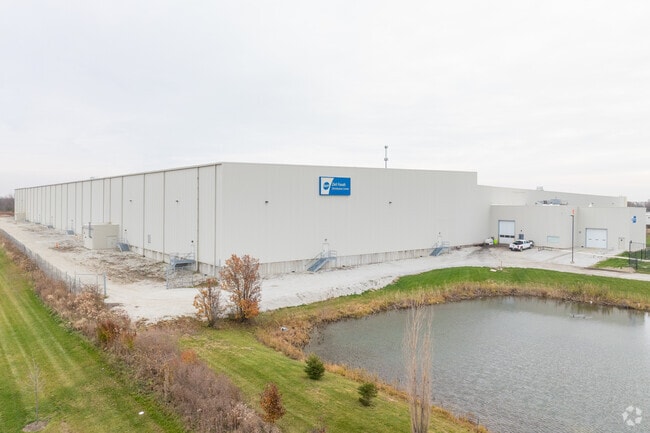
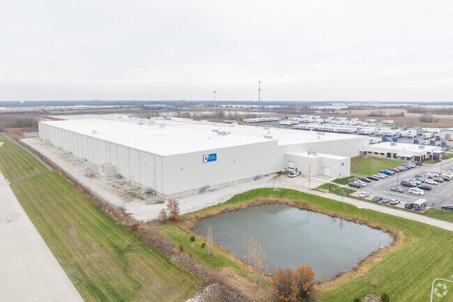
255 Central Ave
Chicago-Naperville-Elgin, IL-IN-WI
Dot Food Sub
21-14-04-301-002
LOT 1 IN DOT FOOD SUB, BEING A SUB OF PRT OF THE SW1/4 OF SEC. 4, T34N-R13E.
Industrialgeneral
Will
X
Illinois
17197C0353G
1
2023
31.69 AC
2024
Far South Cook
883606
Chicago
192,701 SF
DEMOGRAPHICS near 255 Central Ave
1 Mile
3 Mile
5 Mile
2024 Total Population
1,287
27,361
90,030
2029 Population
1,247
26,961
88,936
Pop Growth 2024-2029
(3.11%)
(1.46%)
(1.22%)
Average Age
40
41
41
2024 Total Households
449
10,775
33,757
HH Growth 2024-2029
(3.34%)
(1.75%)
(1.55%)
Median Household Inc
$94,999
$64,816
$71,884
Avg Household Size
2.80
2.50
2.60
2024 Avg HH Vehicles
2.00
2.00
2.00
Median Home Value
$179,777
$148,009
$178,418
Median Year Built
1977
1979
1977
Nearby Places
Map Layers
Map Styles
 Street
 Aerial
- Restaurants
- Banks
- Shops
- Fitness
- Groceries
PUBLIC TRANSPORTATION
COMMUTER RAIL
University Park Station (Metra Electric Line - Northeast Illinois Regional Commuter Railroad (Metra))
DRIVE
WALK
Distance
University Park Station (Metra Electric Line - Northeast Illinois Regional Commuter Railroad (Metra))
6 min
2.6 mi
Richton Park Station (Metra Electric Line - Northeast Illinois Regional Commuter Railroad (Metra))
DRIVE
WALK
Distance
Richton Park Station (Metra Electric Line - Northeast Illinois Regional Commuter Railroad (Metra))
9 min
4.9 mi
AIRPORT
Chicago Midway International
DRIVE
WALK
Distance
Chicago Midway International
44 min
26.8 mi
Freight Ports
Port Milwaukee
DRIVE
WALK
Distance
Port Milwaukee
152 min
120.6 mi
Nearby Properties
Address
Land Use
TOTAL SIZE
Lot Size
Zoning
Address
Land Use
TOTAL SIZE
Lot Size
Zoning
65.63 AC
Address
Land Use
TOTAL SIZE
Lot Size
Zoning
913,500 SF
54.87 AC
Address
Land Use
TOTAL SIZE
Lot Size
Zoning
497,420 SF
35 AC
Address
Land Use
TOTAL SIZE
Lot Size
Zoning
699,960 SF
31.34 AC
Address
Land Use
TOTAL SIZE
Lot Size
Zoning
650,160 SF
35.39 AC
Address
Land Use
TOTAL SIZE
Lot Size
Zoning
60.19 AC
Address
Land Use
TOTAL SIZE
Lot Size
Zoning
455,870 SF
23.32 AC
Address
Land Use
TOTAL SIZE
Lot Size
Zoning
Address
Land Use
TOTAL SIZE
Lot Size
Zoning
471,716 SF
29.58 AC
Address
Land Use
TOTAL SIZE
Lot Size
Zoning
Address
Land Use
TOTAL SIZE
Lot Size
Zoning
142.91 AC
Address
Land Use
TOTAL SIZE
Lot Size
Zoning
70.02 AC
Address
Land Use
TOTAL SIZE
Lot Size
Zoning
15.23 AC
Address
Land Use
TOTAL SIZE
Lot Size
Zoning
100,202 SF
2.90 AC
Address
Land Use
TOTAL SIZE
Lot Size
Zoning
266,177 SF
25 AC
Address
Land Use
TOTAL SIZE
Lot Size
Zoning
268,051 SF
40.82 AC
Address
Land Use
TOTAL SIZE
Lot Size
Zoning
187,953 SF
7.81 AC
Address
Land Use
TOTAL SIZE
Lot Size
Zoning
11.91 AC
Address
Land Use
TOTAL SIZE
Lot Size
Zoning
155,000 SF
10.18 AC
Address
Land Use
TOTAL SIZE
Lot Size
Zoning
3.93 AC
Address
Land Use
TOTAL SIZE
Lot Size
Zoning
Address
Land Use
TOTAL SIZE
Lot Size
Zoning
6,350 SF
1.16 AC
Address
Land Use
TOTAL SIZE
Lot Size
Zoning
Address
Land Use
TOTAL SIZE
Lot Size
Zoning
48,320 SF
6.82 AC
Address
Land Use
TOTAL SIZE
Lot Size
Zoning
Address
Land Use
TOTAL SIZE
Lot Size
Zoning
185,893 SF
16.74 AC
Address
Land Use
TOTAL SIZE
Lot Size
Zoning
142,912 SF
7.71 AC
Address
Land Use
TOTAL SIZE
Lot Size
Zoning
15.64 AC
Address
Land Use
TOTAL SIZE
Lot Size
Zoning
181,745 SF
18.95 AC
The World's #1 Commercial Real Estate Marketplace
Connect with us
© 2025 CoStar Group
The information above has been obtained from sources believed reliable. While we do not doubt its accuracy we have not verified it and make no guarantee, warranty or representation about it. It is your responsibility to independently confirm its accuracy and completeness. Any projections, opinions, assumptions, or estimates used are for example only and do not represent the current or future performance of the property. The value of this transaction to you depends on tax and other factors which should be evaluated by your tax, financial, and legal advisors. You and your advisors should conduct a careful, independent investigation of the property to determine to your satisfaction the suitability of the property for your needs.