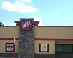
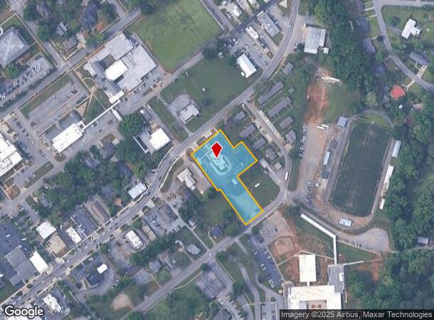
Property Record
255 N Main St, Montevallo, AL 35115
NEARBY LISTINGS FOR SALE OR LEASE
-
-
View all Montevallo listings for sale on LoopNet.com
Property Detail
255 N Main St
Birmingham-Hoover, AL
Storr's & Troy Addition To Montevallo
27-5-21-3-306-012-000
SEC/TWNSHP/RAN 21 22S 03W NBRHD: 07 MONTEVALLO COMMERCIAL R-2
Restaurantdrivein
Shelby
X
Alabama
01021C0050E
13
2024
0.48 AC
2024
I-65 Corr/S Shelby County
030406
Birmingham
3,513 SF
DEMOGRAPHICS near 255 N Main St
1 Mile
3 Mile
5 Mile
2024 Total Population
4,924
8,739
15,019
2029 Population
5,320
9,509
16,302
Pop Growth 2024-2029
+ 8.04%
+ 8.81%
+ 8.54%
Average Age
35
37
38
2024 Total Households
1,634
3,177
5,557
HH Growth 2024-2029
+ 10.04%
+ 10.01%
+ 9.29%
Median Household Inc
$41,639
$41,688
$48,833
Avg Household Size
2.30
2.40
2.50
2024 Avg HH Vehicles
2.00
2.00
2.00
Median Home Value
$175,900
$158,753
$170,276
Median Year Built
1989
1988
1990
Nearby Places
Map Layers
Map Styles
 Street
 Aerial
- Restaurants
- Banks
- Shops
- Fitness
- Groceries
PUBLIC TRANSPORTATION
AIRPORT
Birmingham-Shuttlesworth International
DRIVE
WALK
Distance
Birmingham-Shuttlesworth International
55 min
38.9 mi
Nearby Properties
Address
Land Use
TOTAL SIZE
Lot Size
Zoning
Address
Land Use
TOTAL SIZE
Lot Size
Zoning
10,352 SF
75 AC
Address
Land Use
TOTAL SIZE
Lot Size
Zoning
2,708 SF
297.42 AC
Address
Land Use
TOTAL SIZE
Lot Size
Zoning
16,530 SF
3.76 AC
Address
Land Use
TOTAL SIZE
Lot Size
Zoning
15,620 SF
5.61 AC
Address
Land Use
TOTAL SIZE
Lot Size
Zoning
78,043 SF
4.59 AC
Address
Land Use
TOTAL SIZE
Lot Size
Zoning
87,000 SF
10.93 AC
Address
Land Use
TOTAL SIZE
Lot Size
Zoning
41,325 SF
3.74 AC
Address
Land Use
TOTAL SIZE
Lot Size
Zoning
6,660 SF
7.70 AC
Address
Land Use
TOTAL SIZE
Lot Size
Zoning
2,475 SF
14.20 AC
Address
Land Use
TOTAL SIZE
Lot Size
Zoning
57,281 SF
15 AC
Address
Land Use
TOTAL SIZE
Lot Size
Zoning
159,010 SF
8.60 AC
Address
Land Use
TOTAL SIZE
Lot Size
Zoning
2,569 SF
8 AC
Address
Land Use
TOTAL SIZE
Lot Size
Zoning
7,481 SF
6.20 AC
Address
Land Use
TOTAL SIZE
Lot Size
Zoning
4,128 SF
4.20 AC
Address
Land Use
TOTAL SIZE
Lot Size
Zoning
47,934 SF
3.45 AC
Address
Land Use
TOTAL SIZE
Lot Size
Zoning
72,232 SF
44 AC
Address
Land Use
TOTAL SIZE
Lot Size
Zoning
14,628 SF
2.73 AC
Address
Land Use
TOTAL SIZE
Lot Size
Zoning
19,000 SF
3.10 AC
Address
Land Use
TOTAL SIZE
Lot Size
Zoning
5,800 SF
0.99 AC
Address
Land Use
TOTAL SIZE
Lot Size
Zoning
16,410 SF
1.03 AC
Address
Land Use
TOTAL SIZE
Lot Size
Zoning
17,689 SF
0.98 AC
Address
Land Use
TOTAL SIZE
Lot Size
Zoning
7,760 SF
7.30 AC
Address
Land Use
TOTAL SIZE
Lot Size
Zoning
6,652 SF
2.81 AC
Address
Land Use
TOTAL SIZE
Lot Size
Zoning
60,000 SF
13 AC
Address
Land Use
TOTAL SIZE
Lot Size
Zoning
4,824 SF
0.68 AC
Address
Land Use
TOTAL SIZE
Lot Size
Zoning
10,200 SF
0.97 AC
Address
Land Use
TOTAL SIZE
Lot Size
Zoning
2,100 SF
3.40 AC
Address
Land Use
TOTAL SIZE
Lot Size
Zoning
13,600 SF
1 AC
The World's #1 Commercial Real Estate Marketplace
Connect with us
© 2025 CoStar Group
The information above has been obtained from sources believed reliable. While we do not doubt its accuracy we have not verified it and make no guarantee, warranty or representation about it. It is your responsibility to independently confirm its accuracy and completeness. Any projections, opinions, assumptions, or estimates used are for example only and do not represent the current or future performance of the property. The value of this transaction to you depends on tax and other factors which should be evaluated by your tax, financial, and legal advisors. You and your advisors should conduct a careful, independent investigation of the property to determine to your satisfaction the suitability of the property for your needs.