Property Record
255 S Main St, Cedar Grove, WI 53013
NEARBY LISTINGS FOR SALE OR LEASE
-
-
View all Cedar Grove listings for sale on LoopNet.com
Property Detail
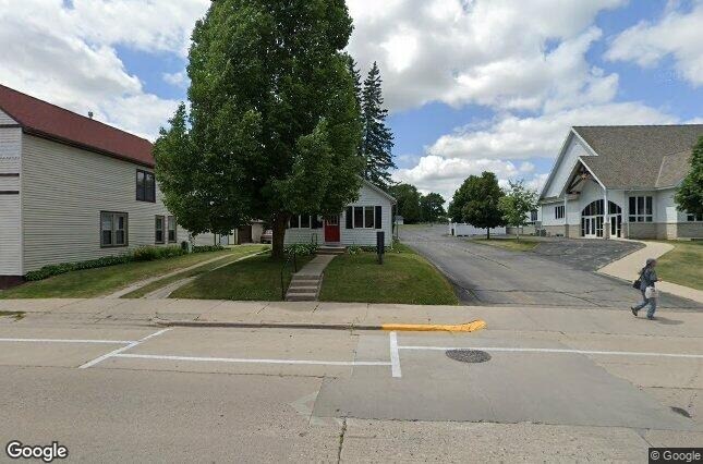
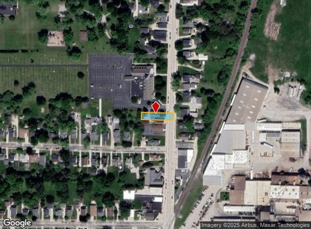
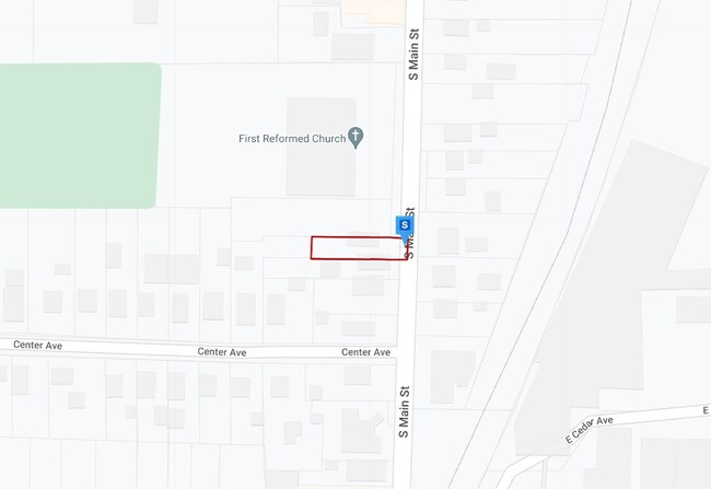
255 S Main St
59112554370
PRT NE NE,SEC 26,COM IN CEN OF PAV OF MAIN ST AT A PNT 994'S OF N LINE SEC 26,TH S 40',W 270'M/L,N 40',TH E 270'M/L TO BEG,EX
Commercialnec
Sheboygan
X
Wisconsin
55117C0455G
0.25 AC
2024
Outlying Sheboygan
2024
Milwaukee/Madison
011302
Sheboygan, WI
DEMOGRAPHICS near 255 S Main St
1 Mile
3 Mile
5 Mile
2024 Total Population
2,709
3,230
8,812
2029 Population
2,667
3,197
8,847
Pop Growth 2024-2029
(1.55%)
(1.02%)
+ 0.40%
Average Age
42
43
43
2024 Total Households
1,082
1,288
3,495
HH Growth 2024-2029
(1.57%)
(1.09%)
+ 0.34%
Median Household Inc
$82,972
$81,085
$73,959
Avg Household Size
2.50
2.50
2.50
2024 Avg HH Vehicles
2.00
2.00
2.00
Median Home Value
$224,107
$232,474
$232,775
Median Year Built
1971
1970
1973
Nearby Places
Map Layers
Map Styles
 Street
 Aerial
- Restaurants
- Banks
- Shops
- Fitness
- Groceries
Nearby Properties
Address
Land Use
TOTAL SIZE
Lot Size
Zoning
Address
Land Use
TOTAL SIZE
Lot Size
Zoning
8.77 AC
Address
Land Use
TOTAL SIZE
Lot Size
Zoning
Address
Land Use
TOTAL SIZE
Lot Size
Zoning
Address
Land Use
TOTAL SIZE
Lot Size
Zoning
Address
Land Use
TOTAL SIZE
Lot Size
Zoning
Address
Land Use
TOTAL SIZE
Lot Size
Zoning
2.78 AC
Address
Land Use
TOTAL SIZE
Lot Size
Zoning
51.62 AC
Address
Land Use
TOTAL SIZE
Lot Size
Zoning
0.79 AC
Address
Land Use
TOTAL SIZE
Lot Size
Zoning
7.50 AC
B1
Address
Land Use
TOTAL SIZE
Lot Size
Zoning
0.85 AC
Address
Land Use
TOTAL SIZE
Lot Size
Zoning
0.76 AC
Address
Land Use
TOTAL SIZE
Lot Size
Zoning
2.14 AC
Address
Land Use
TOTAL SIZE
Lot Size
Zoning
1.44 AC
R1
Address
Land Use
TOTAL SIZE
Lot Size
Zoning
0.91 AC
R1
Address
Land Use
TOTAL SIZE
Lot Size
Zoning
0.76 AC
Address
Land Use
TOTAL SIZE
Lot Size
Zoning
Address
Land Use
TOTAL SIZE
Lot Size
Zoning
0.74 AC
Address
Land Use
TOTAL SIZE
Lot Size
Zoning
0.68 AC
Address
Land Use
TOTAL SIZE
Lot Size
Zoning
10.37 AC
Address
Land Use
TOTAL SIZE
Lot Size
Zoning
1.21 AC
Address
Land Use
TOTAL SIZE
Lot Size
Zoning
1.59 AC
Address
Land Use
TOTAL SIZE
Lot Size
Zoning
1.43 AC
Address
Land Use
TOTAL SIZE
Lot Size
Zoning
0.01 AC
Address
Land Use
TOTAL SIZE
Lot Size
Zoning
1.09 AC
Address
Land Use
TOTAL SIZE
Lot Size
Zoning
4.66 AC
A4
Address
Land Use
TOTAL SIZE
Lot Size
Zoning
0.57 AC
Address
Land Use
TOTAL SIZE
Lot Size
Zoning
0.39 AC
Address
Land Use
TOTAL SIZE
Lot Size
Zoning
0.51 AC
Address
Land Use
TOTAL SIZE
Lot Size
Zoning
0.50 AC
Address
Land Use
TOTAL SIZE
Lot Size
Zoning
0.52 AC
The World's #1 Commercial Real Estate Marketplace
Connect with us
© 2025 CoStar Group
The information above has been obtained from sources believed reliable. While we do not doubt its accuracy we have not verified it and make no guarantee, warranty or representation about it. It is your responsibility to independently confirm its accuracy and completeness. Any projections, opinions, assumptions, or estimates used are for example only and do not represent the current or future performance of the property. The value of this transaction to you depends on tax and other factors which should be evaluated by your tax, financial, and legal advisors. You and your advisors should conduct a careful, independent investigation of the property to determine to your satisfaction the suitability of the property for your needs.