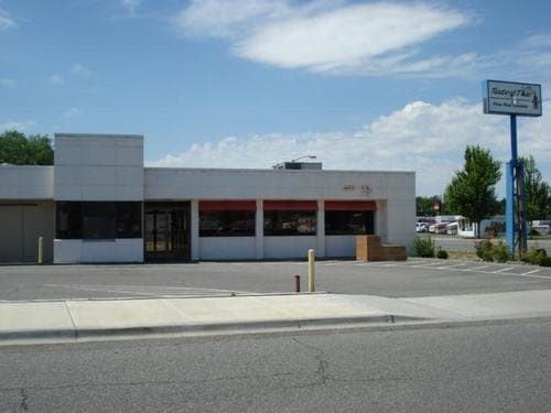
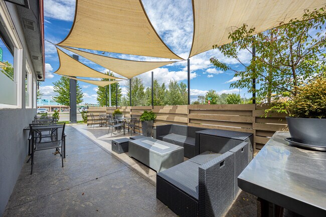
Property Record
255 Williams Blvd, Richland, WA 99354

NEARBY LISTINGS FOR SALE OR LEASE
Property Detail
255 Williams Blvd
Other Market Areas
Plat Of Richland
Kennewick-Richland, WA
LOT 3 BLOCK 618 OF THE PLAT OF RICHLAND RECORDED IN VOLUME 6 & 7 OF PLATS RECORDS OF BENTON COUNTY WASHINGTON. TOGETHER WITH THAT PORTION DESCRIBED AS FOLLOWS BEGINNING AT THE NORTHEAST CORNER OF SAID LOT 4 OF BLOCK 618 THENCE S891351W ALONG THE
111981020618022
Benton
Storebuilding
Washington
2024
3
2024
0.83 AC
010500
Yakima/Kennewick
3,940 SF
DEMOGRAPHICS near 255 Williams Blvd
1 Mile
3 Mile
5 Mile
2024 Total Population
9,443
41,447
110,574
2029 Population
10,114
44,528
119,355
Pop Growth 2024-2029
+ 7.11%
+ 7.43%
+ 7.94%
Average Age
36
38
38
2024 Total Households
3,624
16,405
41,419
HH Growth 2024-2029
+ 7.15%
+ 7.39%
+ 7.87%
Median Household Inc
$65,294
$78,277
$95,574
Avg Household Size
2.50
2.50
2.60
2024 Avg HH Vehicles
2.00
2.00
2.00
Median Home Value
$280,241
$324,797
$359,003
Median Year Built
1949
1971
1997
Nearby Places
Map Layers
Map Styles
 Street
 Aerial
- Restaurants
- Banks
- Shops
- Fitness
- Groceries
PUBLIC TRANSPORTATION
AIRPORT
Tri-Cities
DRIVE
WALK
Distance
Tri-Cities
19 min
10.9 mi
SALE & LEASE HISTORY
LISTING DATE
SALE/LEASE

Jun 10, 2024
For Sale
Nearby Properties
Address
Land Use
TOTAL SIZE
Lot Size
Zoning
Address
Land Use
TOTAL SIZE
Lot Size
Zoning
351,518 SF
16.01 AC
Address
Land Use
TOTAL SIZE
Lot Size
Zoning
562,186 SF
7.61 AC
Address
Land Use
TOTAL SIZE
Lot Size
Zoning
277,530 SF
14.99 AC
Address
Land Use
TOTAL SIZE
Lot Size
Zoning
245,782 SF
10 AC
RICHLAND -
Address
Land Use
TOTAL SIZE
Lot Size
Zoning
342,771 SF
11.59 AC
Address
Land Use
TOTAL SIZE
Lot Size
Zoning
277,559 SF
30 AC
Address
Land Use
TOTAL SIZE
Lot Size
Zoning
143,592 SF
6.86 AC
RICHLAND -
Address
Land Use
TOTAL SIZE
Lot Size
Zoning
428,225 SF
12.60 AC
Address
Land Use
TOTAL SIZE
Lot Size
Zoning
351,217 SF
60.86 AC
Address
Land Use
TOTAL SIZE
Lot Size
Zoning
236,556 SF
11.34 AC
Address
Land Use
TOTAL SIZE
Lot Size
Zoning
185,302 SF
9.13 AC
Address
Land Use
TOTAL SIZE
Lot Size
Zoning
220,970 SF
1.28 AC
Address
Land Use
TOTAL SIZE
Lot Size
Zoning
216,270 SF
22.32 AC
Address
Land Use
TOTAL SIZE
Lot Size
Zoning
90,520 SF
4.32 AC
RICHLAND -
Address
Land Use
TOTAL SIZE
Lot Size
Zoning
94,714 SF
5.22 AC
Address
Land Use
TOTAL SIZE
Lot Size
Zoning
113,052 SF
3.32 AC
Address
Land Use
TOTAL SIZE
Lot Size
Zoning
81,497 SF
16.69 AC
Address
Land Use
TOTAL SIZE
Lot Size
Zoning
69,488 SF
1.69 AC
Address
Land Use
TOTAL SIZE
Lot Size
Zoning
170,307 SF
14.15 AC
Address
Land Use
TOTAL SIZE
Lot Size
Zoning
109,517 SF
4.67 AC
Address
Land Use
TOTAL SIZE
Lot Size
Zoning
69,697 SF
16.83 AC
Address
Land Use
TOTAL SIZE
Lot Size
Zoning
116,318 SF
2.74 AC
Address
Land Use
TOTAL SIZE
Lot Size
Zoning
76,249 SF
13 AC
Address
Land Use
TOTAL SIZE
Lot Size
Zoning
96,486 SF
13.24 AC
Address
Land Use
TOTAL SIZE
Lot Size
Zoning
99,320 SF
5.37 AC
Address
Land Use
TOTAL SIZE
Lot Size
Zoning
208,285 SF
5.24 AC
Address
Land Use
TOTAL SIZE
Lot Size
Zoning
39,875 SF
1.80 AC
Address
Land Use
TOTAL SIZE
Lot Size
Zoning
80,597 SF
6.37 AC
Address
Land Use
TOTAL SIZE
Lot Size
Zoning
86,104 SF
3.26 AC
Address
Land Use
TOTAL SIZE
Lot Size
Zoning
61,068 SF
0.78 AC
The World's #1 Commercial Real Estate Marketplace
Connect with us
© 2026 CoStar Group
The information above has been obtained from sources believed reliable. While we do not doubt its accuracy we have not verified it and make no guarantee, warranty or representation about it. It is your responsibility to independently confirm its accuracy and completeness. Any projections, opinions, assumptions, or estimates used are for example only and do not represent the current or future performance of the property. The value of this transaction to you depends on tax and other factors which should be evaluated by your tax, financial, and legal advisors. You and your advisors should conduct a careful, independent investigation of the property to determine to your satisfaction the suitability of the property for your needs.