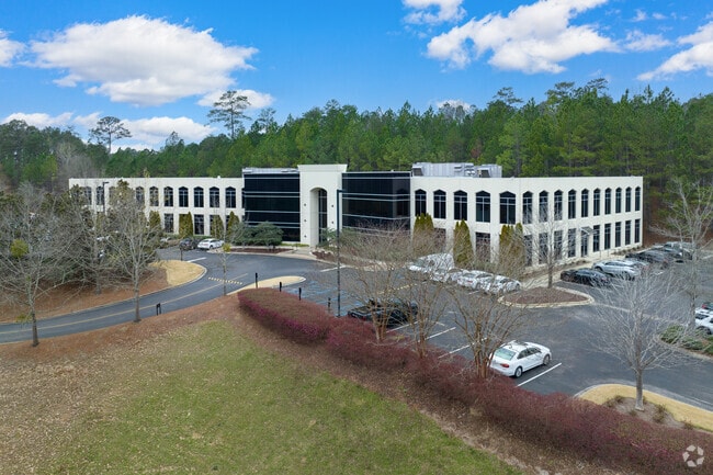
Property Record
2550 Acton Rd, Vestavia, AL 35243


Current Lease Availabilities
Property Detail
2550 Acton Rd
40-00-04-2-000-002.000
LOT 1 MCLEODS ADDITION TO INTERNATIONAL PARK PB 197 PG 19
Commercialnec
Jefferson
CP
Alabama
AE The base floodplain where base flood elevations are provided. AE Zones are now used on new format FIRMs instead of A1-A30 Zones.
1
2024
7 AC
2025
Hwy 280/Jefferson County
012911
Birmingham
60,490 SF
Birmingham, AL
NEARBY LISTINGS FOR SALE OR LEASE
DEMOGRAPHICS near 2550 Acton Rd
1 mile
3 mile
5 mile
2025 Total Population
3,251
48,809
134,692
2030 Population
3,239
48,154
133,331
Pop Growth 2025-2030
(0.37%)
(1.34%)
(1.01%)
Average Age
43
40
39
2025 Total Households
1,304
21,079
55,267
HH Growth 2025-2030
(0.54%)
(1.40%)
(1.20%)
Median Household Inc
$107,615
$97,091
$98,368
Avg Household Size
2.40
2.30
2.30
2025 Avg HH Vehicles
2.00
2.00
2.00
Median Home Value
$556,923
$442,972
$450,397
Median Year Built
1991
1985
1983
Nearby Places
Map Layers
Map Styles
 Street
 Aerial
Transit
 Traffic
 Biking
Places
Listings with unknown addresses are not visible on the map
- Restaurants
- Banks
- Shops
- Fitness
- Groceries
PUBLIC TRANSPORTATION
AIRPORT
Birmingham-Shuttlesworth International
Drive
Walk
Distance
Birmingham-Shuttlesworth International
23 min
14.7 mi
Freight Ports
Port of Mobile
Drive
Walk
Distance
Port of Mobile
271 min
248.1 mi
Nearby Properties
Address
Land Use
TOTAL SIZE
Lot Size
Zoning
Address
Land Use
TOTAL SIZE
Lot Size
Zoning
200,418 SF
7 AC
C1
Address
Land Use
TOTAL SIZE
Lot Size
Zoning
212,615 SF
20 AC
B-2
Address
Land Use
TOTAL SIZE
Lot Size
Zoning
500,279 SF
53 AC
B2
Address
Land Use
TOTAL SIZE
Lot Size
Zoning
347,636 SF
136.83 AC
Address
Land Use
TOTAL SIZE
Lot Size
Zoning
140,853 SF
27 AC
B-2
Address
Land Use
TOTAL SIZE
Lot Size
Zoning
6 AC
C-1
Address
Land Use
TOTAL SIZE
Lot Size
Zoning
169,501 SF
18 AC
E-2
Address
Land Use
TOTAL SIZE
Lot Size
Zoning
153,413 SF
6 AC
C1
Address
Land Use
TOTAL SIZE
Lot Size
Zoning
136,498 SF
11 AC
C1
Address
Land Use
TOTAL SIZE
Lot Size
Zoning
235,082 SF
26.10 AC
C1
Address
Land Use
TOTAL SIZE
Lot Size
Zoning
30,967 SF
17.39 AC
Address
Land Use
TOTAL SIZE
Lot Size
Zoning
102,373 SF
12.33 AC
R1-E
Address
Land Use
TOTAL SIZE
Lot Size
Zoning
329,345 SF
33 AC
C
Address
Land Use
TOTAL SIZE
Lot Size
Zoning
344,434 SF
16 AC
R4
Address
Land Use
TOTAL SIZE
Lot Size
Zoning
239,213 SF
17 AC
C1
Address
Land Use
TOTAL SIZE
Lot Size
Zoning
59,454 SF
4 AC
C1
Address
Land Use
TOTAL SIZE
Lot Size
Zoning
11,492 SF
21.30 AC
Address
Land Use
TOTAL SIZE
Lot Size
Zoning
89,134 SF
7 AC
C-1
Address
Land Use
TOTAL SIZE
Lot Size
Zoning
294,855 SF
30 AC
R4
Address
Land Use
TOTAL SIZE
Lot Size
Zoning
125,165 SF
8 AC
CP
Address
Land Use
TOTAL SIZE
Lot Size
Zoning
121,872 SF
8.70 AC
PB
Address
Land Use
TOTAL SIZE
Lot Size
Zoning
170,850 SF
9 AC
INST
Address
Land Use
TOTAL SIZE
Lot Size
Zoning
251,087 SF
23 AC
R-4
Address
Land Use
TOTAL SIZE
Lot Size
Zoning
5,506 SF
17.36 AC
Address
Land Use
TOTAL SIZE
Lot Size
Zoning
132,501 SF
50.39 AC
Address
Land Use
TOTAL SIZE
Lot Size
Zoning
94,126 SF
10 AC
C-1
Address
Land Use
TOTAL SIZE
Lot Size
Zoning
11,020 SF
110 AC
A1
Address
Land Use
TOTAL SIZE
Lot Size
Zoning
218,354 SF
15 AC
R4
Address
Land Use
TOTAL SIZE
Lot Size
Zoning
83,476 SF
6 AC
C1
The World's #1 Commercial Real Estate Marketplace
Connect with us
© 2026 CoStar Group
The information above has been obtained from sources believed reliable. While we do not doubt its accuracy we have not verified it and make no guarantee, warranty or representation about it. It is your responsibility to independently confirm its accuracy and completeness. Any projections, opinions, assumptions, or estimates used are for example only and do not represent the current or future performance of the property. The value of this transaction to you depends on tax and other factors which should be evaluated by your tax, financial, and legal advisors. You and your advisors should conduct a careful, independent investigation of the property to determine to your satisfaction the suitability of the property for your needs.