Property Record
2550 E Belle Ter, Bakersfield, CA 93307
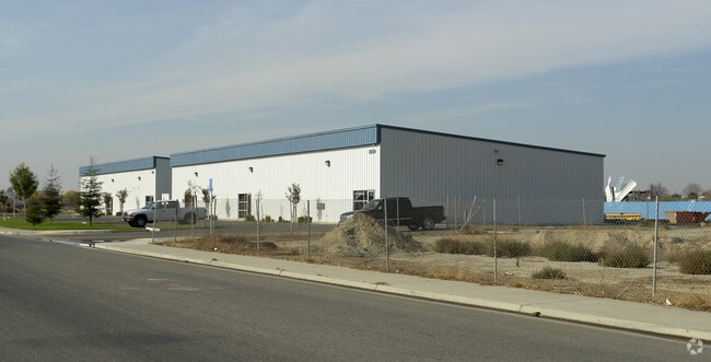


Property Detail
2550 E Belle Ter
167-010-30-00-6
PARCEL MAP 7744 , LOT 11
Warehouse
Kern
M-2
California
B and X Area of moderate flood hazard, usually the area between the limits of the 100-year and 500-year floods.
11
2024
4.92 AC
2025
Southeast Bakersfield
002403
Bakersfield
7,200 SF
Bakersfield-Delano, CA
NEARBY LISTINGS FOR SALE OR LEASE
DEMOGRAPHICS near 2550 E Belle Ter
1 mile
3 mile
5 mile
2025 Total Population
5,852
116,991
286,329
2030 Population
5,891
118,092
289,305
Pop Growth 2025-2030
+ 0.67%
+ 0.94%
+ 1.04%
Average Age
31
33
34
2025 Total Households
1,610
33,113
87,114
HH Growth 2025-2030
+ 0.50%
+ 0.97%
+ 1.07%
Median Household Inc
$44,914
$44,140
$54,084
Avg Household Size
3.50
3.40
3.20
2025 Avg HH Vehicles
2.00
2.00
2.00
Median Home Value
$229,807
$247,777
$278,727
Median Year Built
1980
1966
1972
Nearby Places
Map Layers
Map Styles
 Street
 Aerial
Transit
 Traffic
 Biking
Places
Listings with unknown addresses are not visible on the map
- Restaurants
- Banks
- Shops
- Fitness
- Groceries
PUBLIC TRANSPORTATION
COMMUTER RAIL
Bakersfield (San Joaquins - Amtrak)
Drive
Walk
Distance
Bakersfield (San Joaquins - Amtrak)
9 min
4.1 mi
AIRPORT
Meadows Field
Drive
Walk
Distance
Meadows Field
20 min
11.1 mi
Freight Ports
The Port of Hueneme
Drive
Walk
Distance
The Port of Hueneme
156 min
124.7 mi
SALE & LEASE HISTORY
LISTING DATE
SALE/LEASE

Sep 25, 2016
For Lease
Dec 11, 2017
For Lease
Nearby Properties
Address
Land Use
TOTAL SIZE
Lot Size
Zoning
Address
Land Use
TOTAL SIZE
Lot Size
Zoning
18,000 SF
35.01 AC
M-2
Address
Land Use
TOTAL SIZE
Lot Size
Zoning
16.64 AC
Address
Land Use
TOTAL SIZE
Lot Size
Zoning
825 SF
9.60 AC
M-3
Address
Land Use
TOTAL SIZE
Lot Size
Zoning
188,976 SF
4.92 AC
Address
Land Use
TOTAL SIZE
Lot Size
Zoning
112,052 SF
3.14 AC
R3
Address
Land Use
TOTAL SIZE
Lot Size
Zoning
127,308 SF
8.25 AC
R-2
Address
Land Use
TOTAL SIZE
Lot Size
Zoning
78,140 SF
2.52 AC
CC
Address
Land Use
TOTAL SIZE
Lot Size
Zoning
79,987 SF
3.22 AC
SP
Address
Land Use
TOTAL SIZE
Lot Size
Zoning
0.96 AC
Address
Land Use
TOTAL SIZE
Lot Size
Zoning
2.14 AC
C2
Address
Land Use
TOTAL SIZE
Lot Size
Zoning
17,567 SF
19.39 AC
M2
Address
Land Use
TOTAL SIZE
Lot Size
Zoning
30,854 SF
12.17 AC
M1
Address
Land Use
TOTAL SIZE
Lot Size
Zoning
19,350 SF
2.05 AC
Address
Land Use
TOTAL SIZE
Lot Size
Zoning
1.06 AC
R-1
Address
Land Use
TOTAL SIZE
Lot Size
Zoning
0.41 AC
R1
Address
Land Use
TOTAL SIZE
Lot Size
Zoning
74,890 SF
3.61 AC
SP
Address
Land Use
TOTAL SIZE
Lot Size
Zoning
74,890 SF
3.75 AC
SP
Address
Land Use
TOTAL SIZE
Lot Size
Zoning
53,393 SF
1.69 AC
CC
Address
Land Use
TOTAL SIZE
Lot Size
Zoning
5,000 SF
0.34 AC
Address
Land Use
TOTAL SIZE
Lot Size
Zoning
46,522 SF
3.35 AC
R2
Address
Land Use
TOTAL SIZE
Lot Size
Zoning
22,944 SF
6.51 AC
R2
Address
Land Use
TOTAL SIZE
Lot Size
Zoning
6,439 SF
0.79 AC
CC
Address
Land Use
TOTAL SIZE
Lot Size
Zoning
68,768 SF
2.55 AC
Address
Land Use
TOTAL SIZE
Lot Size
Zoning
106,562 SF
5.30 AC
R3
Address
Land Use
TOTAL SIZE
Lot Size
Zoning
91,124 SF
3.26 AC
R-3
Address
Land Use
TOTAL SIZE
Lot Size
Zoning
7,440 SF
2.33 AC
Address
Land Use
TOTAL SIZE
Lot Size
Zoning
171,948 SF
10.93 AC
M-3
Address
Land Use
TOTAL SIZE
Lot Size
Zoning
14,104 SF
2.56 AC
M-1
Address
Land Use
TOTAL SIZE
Lot Size
Zoning
55,536 SF
4.19 AC
C-2
Address
Land Use
TOTAL SIZE
Lot Size
Zoning
6,412 SF
3.64 AC
The World's #1 Commercial Real Estate Marketplace
Connect with us
© 2026 CoStar Group
The information above has been obtained from sources believed reliable. While we do not doubt its accuracy we have not verified it and make no guarantee, warranty or representation about it. It is your responsibility to independently confirm its accuracy and completeness. Any projections, opinions, assumptions, or estimates used are for example only and do not represent the current or future performance of the property. The value of this transaction to you depends on tax and other factors which should be evaluated by your tax, financial, and legal advisors. You and your advisors should conduct a careful, independent investigation of the property to determine to your satisfaction the suitability of the property for your needs.