No Photo
Property Record
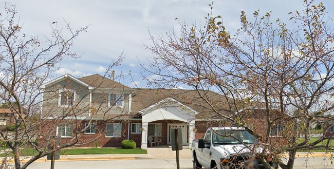
2550 Logan Ln, Lynwood, IL 60411


NEARBY LISTINGS FOR SALE OR LEASE
Property Detail
2550 Logan Ln
33-07-100-034-0000
Lynwood Senior Living Facility Being
Taxexempt
Cook
X
Illinois
17031C0766J
11.02 AC
2023
Southern Cook County
2025
Chicago
828508
Chicago-Naperville-Elgin, IL-IN-WI
66,118 SF
DEMOGRAPHICS near 2550 Logan Ln
1 Mile
3 Mile
5 Mile
2024 Total Population
7,615
59,267
183,961
2029 Population
7,411
58,049
180,943
Pop Growth 2024-2029
(2.68%)
(2.06%)
(1.64%)
Average Age
42
41
41
2024 Total Households
2,847
22,591
70,333
HH Growth 2024-2029
(2.92%)
(2.28%)
(1.85%)
Median Household Inc
$86,509
$69,637
$66,641
Avg Household Size
2.60
2.50
2.50
2024 Avg HH Vehicles
2.00
2.00
2.00
Median Home Value
$178,059
$179,208
$177,839
Median Year Built
1982
1973
1968
Nearby Places
Map Layers
Map Styles
 Street
 Aerial
- Restaurants
- Banks
- Shops
- Fitness
- Groceries
PUBLIC TRANSPORTATION
COMMUTER RAIL
Dyer Amtrak (Cardinal - Amtrak)
DRIVE
WALK
Distance
Dyer Amtrak (Cardinal - Amtrak)
11 min
4.9 mi
Calumet Station (Metra Electric Line - Northeast Illinois Regional Commuter Railroad (Metra))
DRIVE
WALK
Distance
Calumet Station (Metra Electric Line - Northeast Illinois Regional Commuter Railroad (Metra))
16 min
9.0 mi
AIRPORT
Chicago Midway International
DRIVE
WALK
Distance
Chicago Midway International
39 min
25.8 mi
Freight Ports
Port Milwaukee
DRIVE
WALK
Distance
Port Milwaukee
143 min
112.3 mi
Nearby Properties
Address
Land Use
TOTAL SIZE
Lot Size
Zoning
Address
Land Use
TOTAL SIZE
Lot Size
Zoning
879,191 SF
13.93 AC
Address
Land Use
TOTAL SIZE
Lot Size
Zoning
308,022 SF
31.99 AC
R33
Address
Land Use
TOTAL SIZE
Lot Size
Zoning
296,588 SF
36.83 AC
R33
Address
Land Use
TOTAL SIZE
Lot Size
Zoning
125,938 SF
13.32 AC
Address
Land Use
TOTAL SIZE
Lot Size
Zoning
125,938 SF
12.86 AC
Address
Land Use
TOTAL SIZE
Lot Size
Zoning
350,110 SF
24.01 AC
R33
Address
Land Use
TOTAL SIZE
Lot Size
Zoning
454,750 SF
21.15 AC
Address
Land Use
TOTAL SIZE
Lot Size
Zoning
668,326 SF
26.90 AC
Address
Land Use
TOTAL SIZE
Lot Size
Zoning
668,326 SF
28.87 AC
Address
Land Use
TOTAL SIZE
Lot Size
Zoning
197,080 SF
R33
Address
Land Use
TOTAL SIZE
Lot Size
Zoning
70,017 SF
11 AC
R33
Address
Land Use
TOTAL SIZE
Lot Size
Zoning
140,360 SF
15 AC
R33
Address
Land Use
TOTAL SIZE
Lot Size
Zoning
134,623 SF
7.08 AC
Address
Land Use
TOTAL SIZE
Lot Size
Zoning
251,700 SF
19.86 AC
Address
Land Use
TOTAL SIZE
Lot Size
Zoning
82,272 SF
12.55 AC
R3
Address
Land Use
TOTAL SIZE
Lot Size
Zoning
25,910 SF
2.06 AC
Address
Land Use
TOTAL SIZE
Lot Size
Zoning
52,731 SF
2.24 AC
R33
Address
Land Use
TOTAL SIZE
Lot Size
Zoning
63,711 SF
6.98 AC
Address
Land Use
TOTAL SIZE
Lot Size
Zoning
94,500 SF
2.68 AC
Address
Land Use
TOTAL SIZE
Lot Size
Zoning
68,178 SF
0.64 AC
Address
Land Use
TOTAL SIZE
Lot Size
Zoning
244,310 SF
9.32 AC
Address
Land Use
TOTAL SIZE
Lot Size
Zoning
106,840 SF
6.62 AC
R33
Address
Land Use
TOTAL SIZE
Lot Size
Zoning
36,704 SF
3.12 AC
Address
Land Use
TOTAL SIZE
Lot Size
Zoning
61,214 SF
2.06 AC
Address
Land Use
TOTAL SIZE
Lot Size
Zoning
117,855 SF
8.51 AC
Address
Land Use
TOTAL SIZE
Lot Size
Zoning
47,394 SF
2.11 AC
Address
Land Use
TOTAL SIZE
Lot Size
Zoning
8.27 AC
Address
Land Use
TOTAL SIZE
Lot Size
Zoning
37,450 SF
1.78 AC
Address
Land Use
TOTAL SIZE
Lot Size
Zoning
35,920 SF
3.93 AC
Address
Land Use
TOTAL SIZE
Lot Size
Zoning
23,074 SF
2 AC
The World's #1 Commercial Real Estate Marketplace
Connect with us
© 2026 CoStar Group
The information above has been obtained from sources believed reliable. While we do not doubt its accuracy we have not verified it and make no guarantee, warranty or representation about it. It is your responsibility to independently confirm its accuracy and completeness. Any projections, opinions, assumptions, or estimates used are for example only and do not represent the current or future performance of the property. The value of this transaction to you depends on tax and other factors which should be evaluated by your tax, financial, and legal advisors. You and your advisors should conduct a careful, independent investigation of the property to determine to your satisfaction the suitability of the property for your needs.