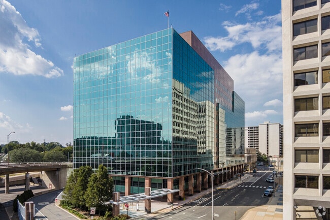
Property Record
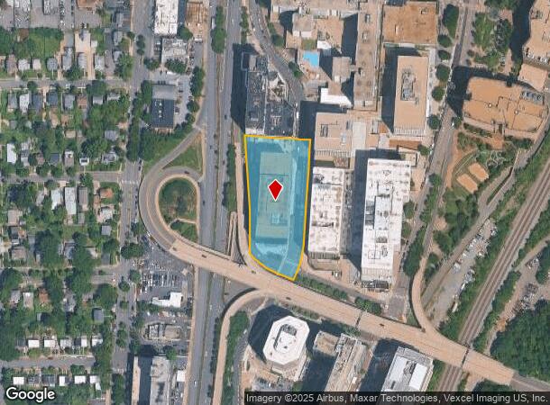
2511 Richmond Hwy, Arlington, VA 22202

Current Lease Availabilities
NEARBY LISTINGS FOR SALE OR LEASE
Property Detail
2511 Richmond Hwy
Washington-Arlington-Alexandria, DC-VA-MD-WV
Brick & Terr
34-020-002
PARC B-1-A RESUB ROP OF WASH BRICK & TERRA COTTA CO & REBECCA ROSS LIPSCOMB EST 87120 SQ FT
Officebuilding
Arlington
X
Virginia
5155190031F
2
2025
2 AC
2025
Crystal City
103405
Washington, DC
346,552 SF
DEMOGRAPHICS near 2511 Richmond Hwy
1 Mile
3 Mile
5 Mile
2024 Total Population
29,069
185,593
729,131
2029 Population
28,777
180,195
697,447
Pop Growth 2024-2029
(1.00%)
(2.91%)
(4.35%)
Average Age
37
38
37
2024 Total Households
15,565
90,613
348,019
HH Growth 2024-2029
(0.82%)
(3.00%)
(4.84%)
Median Household Inc
$117,675
$113,594
$106,290
Avg Household Size
1.80
2.00
2.00
2024 Avg HH Vehicles
1.00
1.00
1.00
Median Home Value
$769,108
$666,012
$677,375
Median Year Built
1991
1971
1973
Nearby Places
Map Layers
Map Styles
 Street
 Aerial
- Restaurants
- Banks
- Shops
- Fitness
- Groceries
PUBLIC TRANSPORTATION
TRANSIT/SUBWAY
Crystal City (Blue Line - Washington Metropolitan Area Transit Authority Metrorail (Metrorail), Yellow Line - Washington Metropolitan Area Transit Authority Metrorail (Metrorail))
DRIVE
WALK
Distance
Crystal City (Blue Line - Washington Metropolitan Area Transit Authority Metrorail (Metrorail), Yellow Line - Washington Metropolitan Area Transit Authority Metrorail (Metrorail))
1 min
9 min
0.5 mi
Crystal City (Fredericksburg Line - Virginia Railway Express, Manassas Line - Virginia Railway Express)
DRIVE
WALK
Distance
Crystal City (Fredericksburg Line - Virginia Railway Express, Manassas Line - Virginia Railway Express)
2 min
15 min
0.8 mi
Ronald Reagan Washington National Airport (Blue Line - Washington Metropolitan Area Transit Authority Metrorail (Metrorail), Yellow Line - Washington Metropolitan Area Transit Authority Metrorail (Metrorail))
DRIVE
WALK
Distance
Ronald Reagan Washington National Airport (Blue Line - Washington Metropolitan Area Transit Authority Metrorail (Metrorail), Yellow Line - Washington Metropolitan Area Transit Authority Metrorail (Metrorail))
3 min
20 min
1.0 mi
COMMUTER RAIL
Crystal City (Fredericksburg Line - Virginia Railway Express, Manassas Line - Virginia Railway Express)
DRIVE
WALK
Distance
Crystal City (Fredericksburg Line - Virginia Railway Express, Manassas Line - Virginia Railway Express)
3 min
14 min
0.7 mi
DRIVE
WALK
Distance
6 min
3.5 mi
AIRPORT
Ronald Reagan Washington Ntl
DRIVE
WALK
Distance
Ronald Reagan Washington Ntl
4 min
1.3 mi
Washington Dulles International
DRIVE
WALK
Distance
Washington Dulles International
45 min
28.5 mi
Baltimore/Washington International Thurgood Marshall
DRIVE
WALK
Distance
Baltimore/Washington International Thurgood Marshall
53 min
35.4 mi
Freight Ports
Port of Baltimore
DRIVE
WALK
Distance
Port of Baltimore
62 min
42.6 mi
Nearby Properties
Address
Land Use
TOTAL SIZE
Lot Size
Zoning
Address
Land Use
TOTAL SIZE
Lot Size
Zoning
900,000 SF
11.10 AC
S-3A
Address
Land Use
TOTAL SIZE
Lot Size
Zoning
128,439 SF
373.22 AC
UNZONED
Address
Land Use
TOTAL SIZE
Lot Size
Zoning
19.46 AC
CG-4
Address
Land Use
TOTAL SIZE
Lot Size
Zoning
3,750,395 SF
10.82 AC
UNZONED
Address
Land Use
TOTAL SIZE
Lot Size
Zoning
6,500,000 SF
92.03 AC
S-3A
Address
Land Use
TOTAL SIZE
Lot Size
Zoning
1,336,013 SF
5.41 AC
D-5
Address
Land Use
TOTAL SIZE
Lot Size
Zoning
1,719,751 SF
39.48 AC
PDR-3;UNZO
Address
Land Use
TOTAL SIZE
Lot Size
Zoning
782,765 SF
94.06 AC
CG-5;CG-6;
Address
Land Use
TOTAL SIZE
Lot Size
Zoning
900,000 SF
260 AC
S-3A
Address
Land Use
TOTAL SIZE
Lot Size
Zoning
437,938 SF
11.28 AC
CG-4
Address
Land Use
TOTAL SIZE
Lot Size
Zoning
4,000,000 SF
352.96 AC
UNZONED
Address
Land Use
TOTAL SIZE
Lot Size
Zoning
1,386,522 SF
5.17 AC
D-8
Address
Land Use
TOTAL SIZE
Lot Size
Zoning
1,796,880 SF
5.49 AC
D-4
Address
Land Use
TOTAL SIZE
Lot Size
Zoning
508,547 SF
4.58 AC
C-O-2.5
Address
Land Use
TOTAL SIZE
Lot Size
Zoning
293,674 SF
13.45 AC
C-O-2.5
Address
Land Use
TOTAL SIZE
Lot Size
Zoning
1,244,070 SF
3.53 AC
UNZONED
Address
Land Use
TOTAL SIZE
Lot Size
Zoning
40,891 SF
2.39 AC
C-O-2.5/C-
Address
Land Use
TOTAL SIZE
Lot Size
Zoning
904,502 SF
8.08 AC
UNZONED
Address
Land Use
TOTAL SIZE
Lot Size
Zoning
899,096 SF
2.26 AC
D-5
Address
Land Use
TOTAL SIZE
Lot Size
Zoning
3,231,903 SF
173.70 AC
UNZONED
Address
Land Use
TOTAL SIZE
Lot Size
Zoning
6,370 SF
3.06 AC
RA6-15
Address
Land Use
TOTAL SIZE
Lot Size
Zoning
14.75 AC
UNZONED
Address
Land Use
TOTAL SIZE
Lot Size
Zoning
35.71 AC
P-S/RA8-18
Address
Land Use
TOTAL SIZE
Lot Size
Zoning
928,014 SF
0.47 AC
MU-12
Address
Land Use
TOTAL SIZE
Lot Size
Zoning
826,736 SF
1.54 AC
D-5
Address
Land Use
TOTAL SIZE
Lot Size
Zoning
336,904 SF
2.12 AC
CDD#15
Address
Land Use
TOTAL SIZE
Lot Size
Zoning
0.55 AC
D-5
Address
Land Use
TOTAL SIZE
Lot Size
Zoning
287,000 SF
1.56 AC
D-5
The World's #1 Commercial Real Estate Marketplace
Connect with us
© 2026 CoStar Group
The information above has been obtained from sources believed reliable. While we do not doubt its accuracy we have not verified it and make no guarantee, warranty or representation about it. It is your responsibility to independently confirm its accuracy and completeness. Any projections, opinions, assumptions, or estimates used are for example only and do not represent the current or future performance of the property. The value of this transaction to you depends on tax and other factors which should be evaluated by your tax, financial, and legal advisors. You and your advisors should conduct a careful, independent investigation of the property to determine to your satisfaction the suitability of the property for your needs.