Property Record
2551 Hampshire Rd, Fort Collins, CO 80526


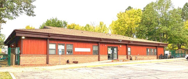

Property Detail
2551 Hampshire Rd
97214-31-001
ALL, CHILDRENS WORLD AT DRAKE LANDING PUD, FTC
Commercialnec
Larimer
RL
Colorado
B and X Area of moderate flood hazard, usually the area between the limits of the 100-year and 500-year floods.
a
2024
0.66 AC
2025
Fort Collins
001104
Denver
4,950 SF
Fort Collins-Loveland, CO
NEARBY LISTINGS FOR SALE OR LEASE
DEMOGRAPHICS near 2551 Hampshire Rd
1 mile
3 mile
5 mile
2025 Total Population
12,428
92,691
157,181
2030 Population
12,875
96,132
162,622
Pop Growth 2025-2030
+ 3.60%
+ 3.71%
+ 3.46%
Average Age
37
34
37
2025 Total Households
4,950
37,114
64,132
HH Growth 2025-2030
+ 3.84%
+ 4.36%
+ 3.95%
Median Household Inc
$88,762
$67,798
$75,370
Avg Household Size
2.40
2.20
2.20
2025 Avg HH Vehicles
2.00
2.00
2.00
Median Home Value
$567,598
$569,257
$601,697
Median Year Built
1986
1986
1989
Nearby Places
Map Layers
Map Styles
 Street
 Aerial
Layers
 Traffic
 Biking
Places
Listings with unknown addresses are not visible on the map
- Restaurants
- Banks
- Shops
- Fitness
- Groceries
SALE & LEASE HISTORY
LISTING DATE
SALE/LEASE

Oct 05, 2022
For Sale
Mar 09, 2022
For Sale
Feb 14, 2019
For Sale
Nearby Properties
Address
Land Use
TOTAL SIZE
Lot Size
Zoning
Address
Land Use
TOTAL SIZE
Lot Size
Zoning
1,096,874 SF
72 AC
CSU
Address
Land Use
TOTAL SIZE
Lot Size
Zoning
219,925 SF
255.47 AC
FA1
Address
Land Use
TOTAL SIZE
Lot Size
Zoning
440,160 SF
29 AC
CSU
Address
Land Use
TOTAL SIZE
Lot Size
Zoning
397,677 SF
28.87 AC
FA
Address
Land Use
TOTAL SIZE
Lot Size
Zoning
521,085 SF
80.60 AC
CSU
Address
Land Use
TOTAL SIZE
Lot Size
Zoning
283,141 SF
24 AC
RL
Address
Land Use
TOTAL SIZE
Lot Size
Zoning
281,945 SF
15.01 AC
NCL
Address
Land Use
TOTAL SIZE
Lot Size
Zoning
295,400 SF
429.46 AC
FA1
Address
Land Use
TOTAL SIZE
Lot Size
Zoning
170,119 SF
12.83 AC
C
Address
Land Use
TOTAL SIZE
Lot Size
Zoning
337,566 SF
2.62 AC
Address
Land Use
TOTAL SIZE
Lot Size
Zoning
173,575 SF
28.86 AC
RL
Address
Land Use
TOTAL SIZE
Lot Size
Zoning
290,000 SF
3.67 AC
D
Address
Land Use
TOTAL SIZE
Lot Size
Zoning
139,965 SF
8.62 AC
CSU
Address
Land Use
TOTAL SIZE
Lot Size
Zoning
115,260 SF
9.08 AC
HC
Address
Land Use
TOTAL SIZE
Lot Size
Zoning
181,956 SF
5 AC
C
Address
Land Use
TOTAL SIZE
Lot Size
Zoning
71,244 SF
5.96 AC
C
Address
Land Use
TOTAL SIZE
Lot Size
Zoning
189,920 SF
6 AC
E
Address
Land Use
TOTAL SIZE
Lot Size
Zoning
263,320 SF
9.39 AC
Address
Land Use
TOTAL SIZE
Lot Size
Zoning
94,079 SF
7 AC
NC
Address
Land Use
TOTAL SIZE
Lot Size
Zoning
363,294 SF
20.28 AC
MMN
Address
Land Use
TOTAL SIZE
Lot Size
Zoning
123,006 SF
10.27 AC
Address
Land Use
TOTAL SIZE
Lot Size
Zoning
159,256 SF
8.64 AC
C
Address
Land Use
TOTAL SIZE
Lot Size
Zoning
367,359 SF
13.36 AC
Address
Land Use
TOTAL SIZE
Lot Size
Zoning
389,012 SF
16.99 AC
MMN
Address
Land Use
TOTAL SIZE
Lot Size
Zoning
95,815 SF
7.46 AC
C
Address
Land Use
TOTAL SIZE
Lot Size
Zoning
61,248 SF
3.67 AC
D
Address
Land Use
TOTAL SIZE
Lot Size
Zoning
93,138 SF
14.45 AC
MMN
Address
Land Use
TOTAL SIZE
Lot Size
Zoning
75,197 SF
6.51 AC
C
The World's #1 Commercial Real Estate Marketplace
Connect with us
© 2026 CoStar Group
The information above has been obtained from sources believed reliable. While we do not doubt its accuracy we have not verified it and make no guarantee, warranty or representation about it. It is your responsibility to independently confirm its accuracy and completeness. Any projections, opinions, assumptions, or estimates used are for example only and do not represent the current or future performance of the property. The value of this transaction to you depends on tax and other factors which should be evaluated by your tax, financial, and legal advisors. You and your advisors should conduct a careful, independent investigation of the property to determine to your satisfaction the suitability of the property for your needs.