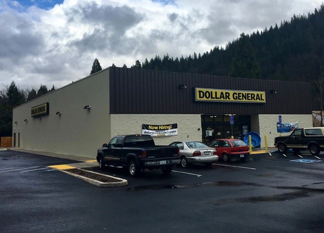
Property Record
2553 Taft Hwy, Bakersfield, CA 93313

Save to a Folder
{{folder.Name}}
{{folder.ListingIds.length}} Properties
{{folder.ListingIds.length}} Property
Create a New Folder
Property Detail
2553 Taft Hwy
184-170-39-00-5
PARCEL MAP 12199 , LOT 1
Storebuilding
KERN
C-H
California
B and X Area of moderate flood hazard, usually the area between the limits of the 100-year and 500-year floods.
1
2025
1.40 AC
2025
SW Outlying Kern County
003220
Bakersfield
7,140 SF
Bakersfield-Delano, CA
NEARBY LISTINGS FOR SALE OR LEASE
DEMOGRAPHICS near 2553 Taft Hwy
1 mile
3 mile
5 mile
2025 Total Population
8,182
73,659
155,562
2030 Population
8,292
74,557
157,500
Pop Growth 2025-2030
+ 1.34%
+ 1.22%
+ 1.25%
Average Age
35
34
34
2025 Total Households
2,151
19,412
44,203
HH Growth 2025-2030
+ 1.30%
+ 1.17%
+ 1.16%
Median Household Inc
$101,816
$87,199
$72,089
Avg Household Size
3.70
3.70
3.40
2025 Avg HH Vehicles
2.00
2.00
2.00
Median Home Value
$367,968
$351,282
$333,347
Median Year Built
2004
1999
1986
Nearby Places
Map Layers
Map Styles
 Street
 Aerial
Layers
 Traffic
 Biking
Places
Listings with unknown addresses are not visible on the map
- Restaurants
- Banks
- Shops
- Fitness
- Groceries
PUBLIC TRANSPORTATION
AIRPORT
Meadows Field
Drive
Walk
Distance
Meadows Field
23 min
13.6 mi
Freight Ports
The Port of Hueneme
Drive
Walk
Distance
The Port of Hueneme
143 min
114.7 mi
SALE & LEASE HISTORY
LISTING DATE
SALE/LEASE

Nov 08, 2017
For Sale
Nearby Properties
Address
Land Use
TOTAL SIZE
Lot Size
Zoning
Address
Land Use
TOTAL SIZE
Lot Size
Zoning
269,429 SF
12.71 AC
R-2
Address
Land Use
TOTAL SIZE
Lot Size
Zoning
17.96 AC
C2
Address
Land Use
TOTAL SIZE
Lot Size
Zoning
218,345 SF
19.54 AC
PCD
Address
Land Use
TOTAL SIZE
Lot Size
Zoning
11,780 SF
11.25 AC
C1
Address
Land Use
TOTAL SIZE
Lot Size
Zoning
69,414 SF
4.47 AC
M1
Address
Land Use
TOTAL SIZE
Lot Size
Zoning
149,499 SF
13.20 AC
GC
Address
Land Use
TOTAL SIZE
Lot Size
Zoning
41,507 SF
10.37 AC
C2
Address
Land Use
TOTAL SIZE
Lot Size
Zoning
10,073 SF
15.48 AC
PCD
Address
Land Use
TOTAL SIZE
Lot Size
Zoning
94,240 SF
4.95 AC
C-2
Address
Land Use
TOTAL SIZE
Lot Size
Zoning
149,777 SF
15.27 AC
C2
Address
Land Use
TOTAL SIZE
Lot Size
Zoning
7.62 AC
C2
Address
Land Use
TOTAL SIZE
Lot Size
Zoning
4.02 AC
C2
Address
Land Use
TOTAL SIZE
Lot Size
Zoning
10.37 AC
C2
Address
Land Use
TOTAL SIZE
Lot Size
Zoning
41.06 AC
Address
Land Use
TOTAL SIZE
Lot Size
Zoning
41,231 SF
6 AC
M-1
Address
Land Use
TOTAL SIZE
Lot Size
Zoning
1,014 SF
3.78 AC
PUD
Address
Land Use
TOTAL SIZE
Lot Size
Zoning
80,172 SF
14.14 AC
C-2
Address
Land Use
TOTAL SIZE
Lot Size
Zoning
50,719 SF
5 AC
C2
Address
Land Use
TOTAL SIZE
Lot Size
Zoning
4,415 SF
5.94 AC
R-1-CH
Address
Land Use
TOTAL SIZE
Lot Size
Zoning
53,620 SF
5.15 AC
M1
Address
Land Use
TOTAL SIZE
Lot Size
Zoning
14,736 SF
1.71 AC
C2
Address
Land Use
TOTAL SIZE
Lot Size
Zoning
3,510 SF
4.66 AC
C2
Address
Land Use
TOTAL SIZE
Lot Size
Zoning
37,869 SF
4.80 AC
M-1
Address
Land Use
TOTAL SIZE
Lot Size
Zoning
21,704 SF
3.44 AC
C-2
Address
Land Use
TOTAL SIZE
Lot Size
Zoning
2,179 SF
14.05 AC
PCD
Address
Land Use
TOTAL SIZE
Lot Size
Zoning
10,404 SF
5.10 AC
M-1
Address
Land Use
TOTAL SIZE
Lot Size
Zoning
10,009 SF
20.04 AC
R-1
Address
Land Use
TOTAL SIZE
Lot Size
Zoning
35,713 SF
4.10 AC
C2
Address
Land Use
TOTAL SIZE
Lot Size
Zoning
8,400 SF
4.78 AC
C1
The World's #1 Commercial Real Estate Marketplace
Connect with us
© 2026 CoStar Group
The information above has been obtained from sources believed reliable. While we do not doubt its accuracy we have not verified it and make no guarantee, warranty or representation about it. It is your responsibility to independently confirm its accuracy and completeness. Any projections, opinions, assumptions, or estimates used are for example only and do not represent the current or future performance of the property. The value of this transaction to you depends on tax and other factors which should be evaluated by your tax, financial, and legal advisors. You and your advisors should conduct a careful, independent investigation of the property to determine to your satisfaction the suitability of the property for your needs.