Property Record
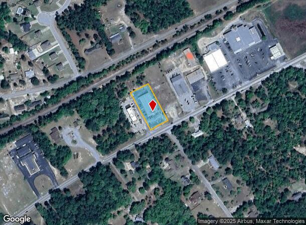
2554 Main St, Elgin, SC 29045
NEARBY LISTINGS FOR SALE OR LEASE
-
-
View all Elgin listings for sale on LoopNet.com
Property Detail
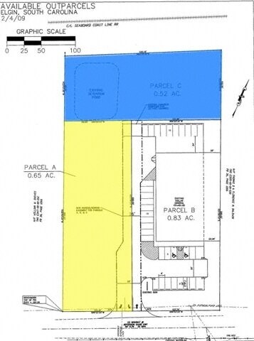
2554 Main St
E335-17-00-032
1756-45 PARCEL B
Storebuilding
Kershaw
X
South Carolina
45055C0416F
0.83 AC
2025
Kershaw County
2025
Columbia
970909
Columbia, SC
9,020 SF
DEMOGRAPHICS near 2554 Main St
1 mile
3 mile
5 mile
2024 Total Population
2,411
14,188
44,568
2029 Population
2,640
15,325
46,624
Pop Growth 2024-2029
+ 9.50%
+ 8.01%
+ 4.61%
Average Age
39
38
38
2024 Total Households
871
5,175
16,468
HH Growth 2024-2029
+ 9.41%
+ 7.96%
+ 4.65%
Median Household Inc
$59,349
$66,282
$71,885
Avg Household Size
2.70
2.70
2.70
2024 Avg HH Vehicles
2.00
2.00
2.00
Median Home Value
$171,037
$178,784
$208,207
Median Year Built
1996
1999
2003
Nearby Places
Map Layers
Map Styles
 Street
 Aerial
Transit
 Traffic
 Biking
Places
Listings with unknown addresses are not visible on the map
- Restaurants
- Banks
- Shops
- Fitness
- Groceries
PUBLIC TRANSPORTATION
AIRPORT
Columbia Metro
Drive
Walk
Distance
Columbia Metro
52 min
30.4 mi
Freight Ports
North Charleston Terminal
Drive
Walk
Distance
North Charleston Terminal
148 min
126.0 mi
Nearby Properties
Address
Land Use
TOTAL SIZE
Lot Size
Zoning
Address
Land Use
TOTAL SIZE
Lot Size
Zoning
2,420 SF
4.03 AC
M-1
Address
Land Use
TOTAL SIZE
Lot Size
Zoning
84,840 SF
5.19 AC
B2
Address
Land Use
TOTAL SIZE
Lot Size
Zoning
40,603 SF
4.64 AC
MUNICIPAL
Address
Land Use
TOTAL SIZE
Lot Size
Zoning
8,467 SF
3.39 AC
PD
Address
Land Use
TOTAL SIZE
Lot Size
Zoning
20.74 AC
PD
Address
Land Use
TOTAL SIZE
Lot Size
Zoning
41,886 SF
4.56 AC
MUNICIPAL
Address
Land Use
TOTAL SIZE
Lot Size
Zoning
9,397 SF
5.50 AC
OI
Address
Land Use
TOTAL SIZE
Lot Size
Zoning
78.22 AC
I1
Address
Land Use
TOTAL SIZE
Lot Size
Zoning
9,610 SF
1.54 AC
PD
Address
Land Use
TOTAL SIZE
Lot Size
Zoning
2,583 SF
1.24 AC
MUNICIPAL
Address
Land Use
TOTAL SIZE
Lot Size
Zoning
7,502 SF
0.74 AC
PD
Address
Land Use
TOTAL SIZE
Lot Size
Zoning
4,220 SF
0.70 AC
PD
Address
Land Use
TOTAL SIZE
Lot Size
Zoning
14,550 SF
2.02 AC
MUNICIPAL
Address
Land Use
TOTAL SIZE
Lot Size
Zoning
63.97 AC
R15
Address
Land Use
TOTAL SIZE
Lot Size
Zoning
7,366 SF
0.52 AC
MUNICIPAL
Address
Land Use
TOTAL SIZE
Lot Size
Zoning
5,403 SF
0.73 AC
PD
Address
Land Use
TOTAL SIZE
Lot Size
Zoning
6,412 SF
0.84 AC
PD
Address
Land Use
TOTAL SIZE
Lot Size
Zoning
9,075 SF
0.86 AC
PD
Address
Land Use
TOTAL SIZE
Lot Size
Zoning
2,651 SF
0.95 AC
MUNICIPAL
Address
Land Use
TOTAL SIZE
Lot Size
Zoning
7,794 SF
0.94 AC
PD
Address
Land Use
TOTAL SIZE
Lot Size
Zoning
9,020 SF
0.83 AC
MUNICIPAL
Address
Land Use
TOTAL SIZE
Lot Size
Zoning
3,194 SF
0.66 AC
PD
Address
Land Use
TOTAL SIZE
Lot Size
Zoning
7,569 SF
0.44 AC
PD
Address
Land Use
TOTAL SIZE
Lot Size
Zoning
1,300 SF
16.99 AC
RU
Address
Land Use
TOTAL SIZE
Lot Size
Zoning
1,620 SF
15.25 AC
RD2
Address
Land Use
TOTAL SIZE
Lot Size
Zoning
5,425 SF
0.89 AC
PD
Address
Land Use
TOTAL SIZE
Lot Size
Zoning
6,669 SF
0.36 AC
PD
Address
Land Use
TOTAL SIZE
Lot Size
Zoning
5,090 SF
0.67 AC
PD
Address
Land Use
TOTAL SIZE
Lot Size
Zoning
5,654 SF
PD
Address
Land Use
TOTAL SIZE
Lot Size
Zoning
5,817 SF
0.50 AC
PD
The World's #1 Commercial Real Estate Marketplace
Connect with us
© 2026 CoStar Group
The information above has been obtained from sources believed reliable. While we do not doubt its accuracy we have not verified it and make no guarantee, warranty or representation about it. It is your responsibility to independently confirm its accuracy and completeness. Any projections, opinions, assumptions, or estimates used are for example only and do not represent the current or future performance of the property. The value of this transaction to you depends on tax and other factors which should be evaluated by your tax, financial, and legal advisors. You and your advisors should conduct a careful, independent investigation of the property to determine to your satisfaction the suitability of the property for your needs.