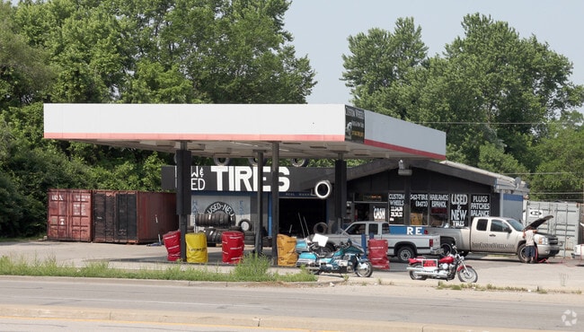
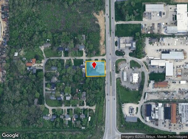
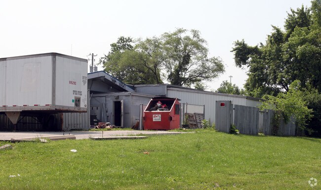
Property Record
2554 N Emerson Ave, Indianapolis, IN 46218
NEARBY LISTINGS FOR SALE OR LEASE
Property Detail
2554 N Emerson Ave
Indianapolis-Carmel-Anderson, IN
Brookwood Add 185Ft W End
49-07-28-107-013.000-101
BROOKWOOD ADD 185FT W END L8 & L9
Servicestation
Marion
X
Indiana
18097C0162F
8,9
2023
0.60 AC
2024
Lawrence/East County
352300
Indianapolis
2,073 SF
DEMOGRAPHICS near 2554 N Emerson Ave
1 Mile
3 Mile
5 Mile
2024 Total Population
10,193
106,580
284,065
2029 Population
10,253
107,240
284,924
Pop Growth 2024-2029
+ 0.59%
+ 0.62%
+ 0.30%
Average Age
37
38
37
2024 Total Households
4,122
44,370
123,023
HH Growth 2024-2029
+ 0.46%
+ 0.48%
+ 0.24%
Median Household Inc
$31,262
$40,188
$51,128
Avg Household Size
2.40
2.30
2.20
2024 Avg HH Vehicles
1.00
1.00
1.00
Median Home Value
$78,133
$123,326
$176,062
Median Year Built
1957
1954
1957
Nearby Places
Map Layers
Map Styles
 Street
 Aerial
- Restaurants
- Banks
- Shops
- Fitness
- Groceries
PUBLIC TRANSPORTATION
COMMUTER RAIL
DRIVE
WALK
Distance
12 min
7.1 mi
AIRPORT
Indianapolis International
DRIVE
WALK
Distance
Indianapolis International
33 min
19.3 mi
SALE & LEASE HISTORY
LISTING DATE
SALE/LEASE

Oct 12, 2017
For Sale
Aug 10, 2017
For Sale
Nearby Properties
Address
Land Use
TOTAL SIZE
Lot Size
Zoning
Address
Land Use
TOTAL SIZE
Lot Size
Zoning
25,146 SF
28.58 AC
ZO01
Address
Land Use
TOTAL SIZE
Lot Size
Zoning
2,451 SF
0.46 AC
ZO01
Address
Land Use
TOTAL SIZE
Lot Size
Zoning
866 SF
14.33 AC
ZO01
Address
Land Use
TOTAL SIZE
Lot Size
Zoning
6,000 SF
8.79 AC
ZO01
Address
Land Use
TOTAL SIZE
Lot Size
Zoning
4,588 SF
24.33 AC
ZO01
Address
Land Use
TOTAL SIZE
Lot Size
Zoning
2,142 SF
9.91 AC
ZO01
Address
Land Use
TOTAL SIZE
Lot Size
Zoning
713,497 SF
69.91 AC
ZO01
Address
Land Use
TOTAL SIZE
Lot Size
Zoning
3,523 SF
2.39 AC
ZO01
Address
Land Use
TOTAL SIZE
Lot Size
Zoning
925,384 SF
49.48 AC
ZO01
Address
Land Use
TOTAL SIZE
Lot Size
Zoning
268,930 SF
20.55 AC
ZO01
Address
Land Use
TOTAL SIZE
Lot Size
Zoning
66,953 SF
10.87 AC
ZO01
Address
Land Use
TOTAL SIZE
Lot Size
Zoning
156,720 SF
6.18 AC
ZO01
Address
Land Use
TOTAL SIZE
Lot Size
Zoning
269,450 SF
5.85 AC
Address
Land Use
TOTAL SIZE
Lot Size
Zoning
1,865 SF
22.15 AC
ZO01
Address
Land Use
TOTAL SIZE
Lot Size
Zoning
8,054 SF
20.62 AC
Address
Land Use
TOTAL SIZE
Lot Size
Zoning
71,800 SF
1.88 AC
ZO01
Address
Land Use
TOTAL SIZE
Lot Size
Zoning
254,641 SF
29.53 AC
Address
Land Use
TOTAL SIZE
Lot Size
Zoning
6,252 SF
17.02 AC
ZO01
Address
Land Use
TOTAL SIZE
Lot Size
Zoning
77,518 SF
11.69 AC
ZO01
Address
Land Use
TOTAL SIZE
Lot Size
Zoning
1,594 SF
6.47 AC
ZO01
Address
Land Use
TOTAL SIZE
Lot Size
Zoning
6.53 AC
ZO01
Address
Land Use
TOTAL SIZE
Lot Size
Zoning
3,920 SF
26.08 AC
ZO01
Address
Land Use
TOTAL SIZE
Lot Size
Zoning
1,282,569 SF
65.04 AC
ZO01
Address
Land Use
TOTAL SIZE
Lot Size
Zoning
1,962 SF
8.66 AC
ZO01
Address
Land Use
TOTAL SIZE
Lot Size
Zoning
55,047 SF
2.01 AC
ZO01
Address
Land Use
TOTAL SIZE
Lot Size
Zoning
593,228 SF
34.14 AC
ZO01
Address
Land Use
TOTAL SIZE
Lot Size
Zoning
14,482 SF
8.89 AC
ZO01
Address
Land Use
TOTAL SIZE
Lot Size
Zoning
520,902 SF
17.92 AC
ZO01
Address
Land Use
TOTAL SIZE
Lot Size
Zoning
25,047 SF
0.45 AC
ZO01
Address
Land Use
TOTAL SIZE
Lot Size
Zoning
53,988 SF
13.35 AC
ZO01
The World's #1 Commercial Real Estate Marketplace
Connect with us
© 2026 CoStar Group
The information above has been obtained from sources believed reliable. While we do not doubt its accuracy we have not verified it and make no guarantee, warranty or representation about it. It is your responsibility to independently confirm its accuracy and completeness. Any projections, opinions, assumptions, or estimates used are for example only and do not represent the current or future performance of the property. The value of this transaction to you depends on tax and other factors which should be evaluated by your tax, financial, and legal advisors. You and your advisors should conduct a careful, independent investigation of the property to determine to your satisfaction the suitability of the property for your needs.