Property Record
2555 County Road 58, Manvel, TX 77578
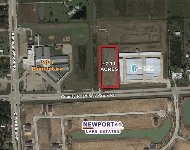

Property Detail
2555 County Road 58
Houston-Pasadena-The Woodlands, TX
COUNTY ROAD 58 STORAGE (A0563 HT&BRR) LOT RESERVE A ACRES 2.135
2964-0000-000
BRAZORIA
Commercialnec
Texas
AE The base floodplain where base flood elevations are provided. AE Zones are now used on new format FIRMs instead of A1-A30 Zones.
a
2024
2.13 AC
2025
South
660615
Houston
14,575 SF
NEARBY LISTINGS FOR SALE OR LEASE
DEMOGRAPHICS near 2555 County Road 58
1 mile
3 mile
5 mile
2025 Total Population
8,383
55,201
151,773
2030 Population
9,377
61,609
169,506
Pop Growth 2025-2030
+ 11.86%
+ 11.61%
+ 11.68%
Average Age
33
35
36
2025 Total Households
2,513
17,040
48,980
HH Growth 2025-2030
+ 12.14%
+ 11.76%
+ 11.82%
Median Household Inc
$103,352
$126,102
$112,935
Avg Household Size
3.30
3.20
3.00
2025 Avg HH Vehicles
2.00
2.00
2.00
Median Home Value
$309,783
$365,973
$354,717
Median Year Built
2010
2010
2009
Nearby Places
Map Layers
Map Styles
 Street
 Aerial
Layers
 Traffic
 Biking
Places
Listings with unknown addresses are not visible on the map
- Restaurants
- Banks
- Shops
- Fitness
- Groceries
PUBLIC TRANSPORTATION
AIRPORT
William P Hobby
Drive
Walk
Distance
William P Hobby
30 min
17.0 mi
Freight Ports
Port of Houston
Drive
Walk
Distance
Port of Houston
35 min
23.7 mi
SALE & LEASE HISTORY
LISTING DATE
SALE/LEASE

Jun 21, 2018
For Sale
Nearby Properties
Address
Land Use
TOTAL SIZE
Lot Size
Zoning
Address
Land Use
TOTAL SIZE
Lot Size
Zoning
241,351 SF
60.11 AC
Address
Land Use
TOTAL SIZE
Lot Size
Zoning
367,766 SF
43.71 AC
Address
Land Use
TOTAL SIZE
Lot Size
Zoning
372,280 SF
14.70 AC
0021
Address
Land Use
TOTAL SIZE
Lot Size
Zoning
379,493 SF
14.27 AC
Address
Land Use
TOTAL SIZE
Lot Size
Zoning
323,168 SF
12.80 AC
Address
Land Use
TOTAL SIZE
Lot Size
Zoning
66,998 SF
11.34 AC
Address
Land Use
TOTAL SIZE
Lot Size
Zoning
115,423 SF
12.13 AC
Address
Land Use
TOTAL SIZE
Lot Size
Zoning
228,276 SF
9.43 AC
0036
Address
Land Use
TOTAL SIZE
Lot Size
Zoning
172,256 SF
6.13 AC
Address
Land Use
TOTAL SIZE
Lot Size
Zoning
70,033 SF
17.97 AC
Address
Land Use
TOTAL SIZE
Lot Size
Zoning
58,985 SF
4.34 AC
Address
Land Use
TOTAL SIZE
Lot Size
Zoning
107,915 SF
9.29 AC
Address
Land Use
TOTAL SIZE
Lot Size
Zoning
152,722 SF
16.70 AC
Address
Land Use
TOTAL SIZE
Lot Size
Zoning
59,618 SF
4.50 AC
Address
Land Use
TOTAL SIZE
Lot Size
Zoning
49,404 SF
1.90 AC
Address
Land Use
TOTAL SIZE
Lot Size
Zoning
15.28 AC
0015
Address
Land Use
TOTAL SIZE
Lot Size
Zoning
13.85 AC
Address
Land Use
TOTAL SIZE
Lot Size
Zoning
67,748 SF
9.28 AC
Address
Land Use
TOTAL SIZE
Lot Size
Zoning
70,071 SF
45.52 AC
Address
Land Use
TOTAL SIZE
Lot Size
Zoning
140,662 SF
11.15 AC
Address
Land Use
TOTAL SIZE
Lot Size
Zoning
79,192 SF
9.36 AC
0029
Address
Land Use
TOTAL SIZE
Lot Size
Zoning
132,938 SF
29 AC
MZY
Address
Land Use
TOTAL SIZE
Lot Size
Zoning
91,574 SF
Address
Land Use
TOTAL SIZE
Lot Size
Zoning
28,708 SF
9.57 AC
Address
Land Use
TOTAL SIZE
Lot Size
Zoning
44,735 SF
120.87 AC
0010
Address
Land Use
TOTAL SIZE
Lot Size
Zoning
125,723 SF
2.63 AC
Address
Land Use
TOTAL SIZE
Lot Size
Zoning
51,996 SF
10.08 AC
0012
Address
Land Use
TOTAL SIZE
Lot Size
Zoning
125,636 SF
2.25 AC
Address
Land Use
TOTAL SIZE
Lot Size
Zoning
214,827 SF
15.70 AC
0033
Address
Land Use
TOTAL SIZE
Lot Size
Zoning
21,840 SF
3.07 AC
The World's #1 Commercial Real Estate Marketplace
Connect with us
© 2026 CoStar Group
The information above has been obtained from sources believed reliable. While we do not doubt its accuracy we have not verified it and make no guarantee, warranty or representation about it. It is your responsibility to independently confirm its accuracy and completeness. Any projections, opinions, assumptions, or estimates used are for example only and do not represent the current or future performance of the property. The value of this transaction to you depends on tax and other factors which should be evaluated by your tax, financial, and legal advisors. You and your advisors should conduct a careful, independent investigation of the property to determine to your satisfaction the suitability of the property for your needs.