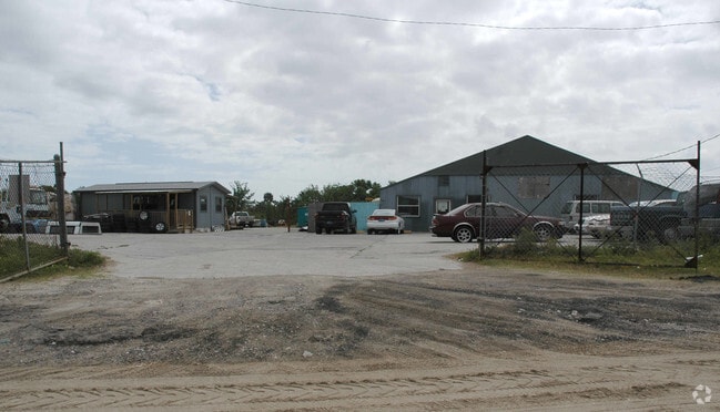
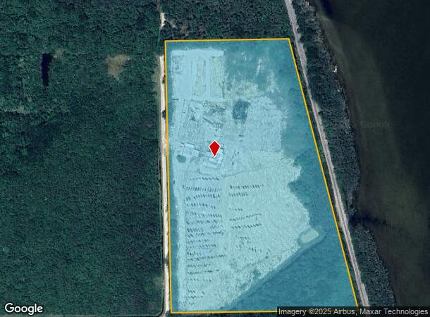
Property Record
2555 Hammock Rd, Mims, FL 32754
NEARBY LISTINGS FOR SALE OR LEASE
Property Detail
2555 Hammock Rd
Palm Bay-Melbourne-Titusville, FL
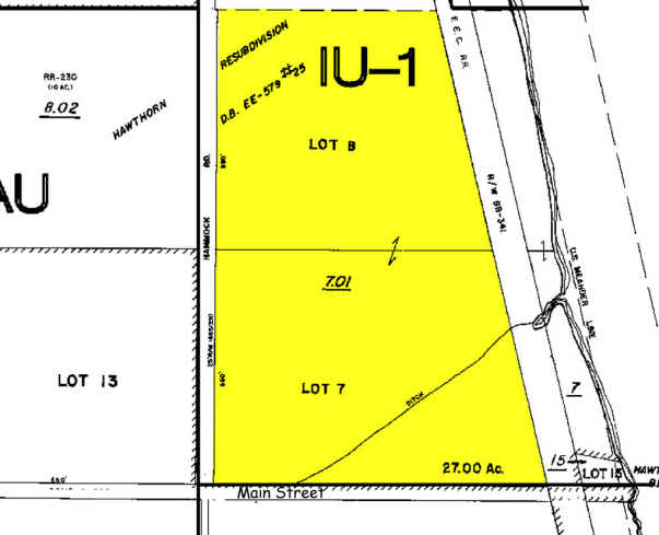
Hawthornes Resubd As Desc In Db Ee Pg 59
21-35-16-25-00000.0-0007.01
HAWTHORNES RESUBD AS DESC IN DB EE PG 597 THAT PART OF LOTS 7 & 8 LYING E OF HAMMOCK ROAD & W OF FEC RR PAR 8.03
Storageyardjunkautowreckingsalvage
Brevard
AE
Florida
12009C0115H
7
2024
23.04 AC
2025
Brevard County
060105
Orlando
4,555 SF
DEMOGRAPHICS near 2555 Hammock Rd
1 Mile
3 Mile
5 Mile
2024 Total Population
955
14,980
34,349
2029 Population
1,056
16,478
37,745
Pop Growth 2024-2029
+ 10.58%
+ 10.00%
+ 9.89%
Average Age
44
45
45
2024 Total Households
389
6,204
14,259
HH Growth 2024-2029
+ 10.80%
+ 9.91%
+ 9.74%
Median Household Inc
$38,278
$50,731
$51,411
Avg Household Size
2.40
2.30
2.30
2024 Avg HH Vehicles
2.00
2.00
2.00
Median Home Value
$144,298
$204,754
$223,224
Median Year Built
1983
1981
1981
Nearby Places
Map Layers
Map Styles
 Street
 Aerial
- Restaurants
- Banks
- Shops
- Fitness
- Groceries
Nearby Properties
Address
Land Use
TOTAL SIZE
Lot Size
Zoning
Address
Land Use
TOTAL SIZE
Lot Size
Zoning
440,368 SF
60.44 AC
HM
Address
Land Use
TOTAL SIZE
Lot Size
Zoning
172,172 SF
116.12 AC
P
Address
Land Use
TOTAL SIZE
Lot Size
Zoning
87,904 SF
13.16 AC
RU19
Address
Land Use
TOTAL SIZE
Lot Size
Zoning
54,816 SF
10.11 AC
BU-1
Address
Land Use
TOTAL SIZE
Lot Size
Zoning
113,576 SF
19.98 AC
P
Address
Land Use
TOTAL SIZE
Lot Size
Zoning
46.75 AC
GML
Address
Land Use
TOTAL SIZE
Lot Size
Zoning
97,463 SF
19.50 AC
P
Address
Land Use
TOTAL SIZE
Lot Size
Zoning
10,248 SF
41.06 AC
RU-1-7
Address
Land Use
TOTAL SIZE
Lot Size
Zoning
87,836 SF
8.89 AC
CC
Address
Land Use
TOTAL SIZE
Lot Size
Zoning
24,364 SF
14.08 AC
Address
Land Use
TOTAL SIZE
Lot Size
Zoning
63,506 SF
18.94 AC
GU
Address
Land Use
TOTAL SIZE
Lot Size
Zoning
55,304 SF
5 AC
OR
Address
Land Use
TOTAL SIZE
Lot Size
Zoning
9,961 SF
13.71 AC
RVP
Address
Land Use
TOTAL SIZE
Lot Size
Zoning
21,934 SF
8.05 AC
BU-1
Address
Land Use
TOTAL SIZE
Lot Size
Zoning
44,861 SF
3.11 AC
HM
Address
Land Use
TOTAL SIZE
Lot Size
Zoning
37,971 SF
11.86 AC
GML
Address
Land Use
TOTAL SIZE
Lot Size
Zoning
17,815 SF
2.21 AC
BU-1
Address
Land Use
TOTAL SIZE
Lot Size
Zoning
22,445 SF
16.19 AC
INL
Address
Land Use
TOTAL SIZE
Lot Size
Zoning
11,486 SF
88 AC
RRMH1
Address
Land Use
TOTAL SIZE
Lot Size
Zoning
31.19 AC
AU
Address
Land Use
TOTAL SIZE
Lot Size
Zoning
19,137 SF
5.91 AC
BU-1
Address
Land Use
TOTAL SIZE
Lot Size
Zoning
24,088 SF
9.50 AC
IN(L)
Address
Land Use
TOTAL SIZE
Lot Size
Zoning
17,042 SF
2.75 AC
BU2
Address
Land Use
TOTAL SIZE
Lot Size
Zoning
4,860 SF
10.38 AC
RVP
Address
Land Use
TOTAL SIZE
Lot Size
Zoning
73,022 SF
5.34 AC
IU
Address
Land Use
TOTAL SIZE
Lot Size
Zoning
4,164 SF
8.98 AC
RVP
Address
Land Use
TOTAL SIZE
Lot Size
Zoning
40,455 SF
13.75 AC
PIP
Address
Land Use
TOTAL SIZE
Lot Size
Zoning
22,879 SF
6.48 AC
PUD
Address
Land Use
TOTAL SIZE
Lot Size
Zoning
10,291 SF
10.45 AC
BU-2
Address
Land Use
TOTAL SIZE
Lot Size
Zoning
24,656 SF
6.69 AC
BU1BU2
The World's #1 Commercial Real Estate Marketplace
Connect with us
© 2025 CoStar Group
The information above has been obtained from sources believed reliable. While we do not doubt its accuracy we have not verified it and make no guarantee, warranty or representation about it. It is your responsibility to independently confirm its accuracy and completeness. Any projections, opinions, assumptions, or estimates used are for example only and do not represent the current or future performance of the property. The value of this transaction to you depends on tax and other factors which should be evaluated by your tax, financial, and legal advisors. You and your advisors should conduct a careful, independent investigation of the property to determine to your satisfaction the suitability of the property for your needs.