Property Record
2555 Highway 81 N, Anderson, SC 29621
NEARBY LISTINGS FOR SALE OR LEASE
-
-
View all Anderson listings for lease on LoopNet.com
Property Detail
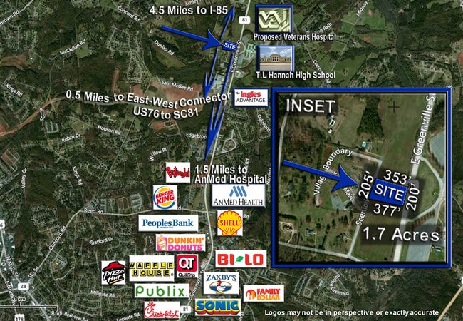
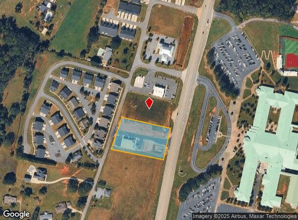
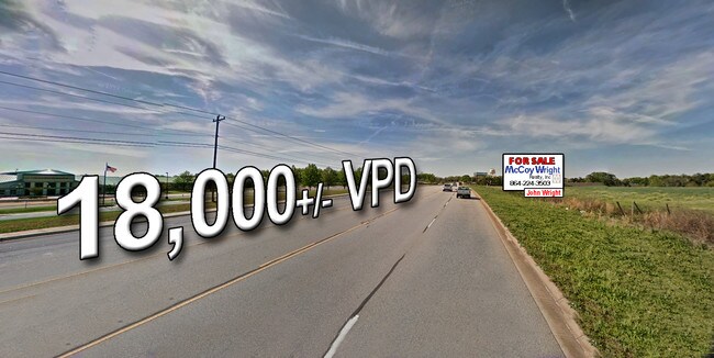
2555 Highway 81 N
146-00-08-020
CP S 2061/7 F000 D000 HWY 81N 1.68 AC
Commercialacreage
Anderson
X
South Carolina
45007C0235F
1.68 AC
2024
Anderson County
2024
Greenville/Spartanburg
011201
Greenville-Anderson-Greer, SC
DEMOGRAPHICS near 2555 Highway 81 N
1 mile
3 mile
5 mile
2024 Total Population
2,034
24,368
55,522
2029 Population
2,178
25,879
59,398
Pop Growth 2024-2029
+ 7.08%
+ 6.20%
+ 6.98%
Average Age
41
42
40
2024 Total Households
774
9,568
22,073
HH Growth 2024-2029
+ 7.24%
+ 6.27%
+ 7.10%
Median Household Inc
$87,880
$75,425
$59,170
Avg Household Size
2.60
2.50
2.40
2024 Avg HH Vehicles
2.00
2.00
2.00
Median Home Value
$258,841
$249,016
$208,439
Median Year Built
2000
1992
1986
Nearby Places
Map Layers
Map Styles
 Street
 Aerial
Transit
 Traffic
 Biking
Places
Listings with unknown addresses are not visible on the map
- Restaurants
- Banks
- Shops
- Fitness
- Groceries
SALE & LEASE HISTORY
LISTING DATE
SALE/LEASE

Sep 24, 2016
For Sale
Jul 27, 2017
For Lease
Nearby Properties
Address
Land Use
TOTAL SIZE
Lot Size
Zoning
Address
Land Use
TOTAL SIZE
Lot Size
Zoning
17,286 SF
19.71 AC
Address
Land Use
TOTAL SIZE
Lot Size
Zoning
66,400 SF
12 AC
Address
Land Use
TOTAL SIZE
Lot Size
Zoning
15,168 SF
11.99 AC
Address
Land Use
TOTAL SIZE
Lot Size
Zoning
7,568 SF
10.99 AC
Address
Land Use
TOTAL SIZE
Lot Size
Zoning
1,475 SF
9.65 AC
Address
Land Use
TOTAL SIZE
Lot Size
Zoning
1,328 SF
8.79 AC
Address
Land Use
TOTAL SIZE
Lot Size
Zoning
91,455 SF
12 AC
Address
Land Use
TOTAL SIZE
Lot Size
Zoning
729 SF
10 AC
Address
Land Use
TOTAL SIZE
Lot Size
Zoning
87,670 SF
5.81 AC
Address
Land Use
TOTAL SIZE
Lot Size
Zoning
42,416 SF
6.45 AC
Address
Land Use
TOTAL SIZE
Lot Size
Zoning
40,071 SF
18.83 AC
Address
Land Use
TOTAL SIZE
Lot Size
Zoning
25,908 SF
12.50 AC
Address
Land Use
TOTAL SIZE
Lot Size
Zoning
49,123 SF
5.14 AC
Address
Land Use
TOTAL SIZE
Lot Size
Zoning
33,173 SF
4.59 AC
Address
Land Use
TOTAL SIZE
Lot Size
Zoning
91,698 SF
10.04 AC
Address
Land Use
TOTAL SIZE
Lot Size
Zoning
67,563 SF
17.23 AC
Address
Land Use
TOTAL SIZE
Lot Size
Zoning
31,616 SF
4.99 AC
Address
Land Use
TOTAL SIZE
Lot Size
Zoning
1,446 SF
5.15 AC
Address
Land Use
TOTAL SIZE
Lot Size
Zoning
2,408 SF
3.89 AC
Address
Land Use
TOTAL SIZE
Lot Size
Zoning
80,205 SF
9.58 AC
Address
Land Use
TOTAL SIZE
Lot Size
Zoning
4,058 SF
8 AC
Address
Land Use
TOTAL SIZE
Lot Size
Zoning
46,410 SF
4.88 AC
Address
Land Use
TOTAL SIZE
Lot Size
Zoning
30,736 SF
3.05 AC
Address
Land Use
TOTAL SIZE
Lot Size
Zoning
24.90 AC
Address
Land Use
TOTAL SIZE
Lot Size
Zoning
45,085 SF
6.96 AC
Address
Land Use
TOTAL SIZE
Lot Size
Zoning
8,564 SF
4.32 AC
Address
Land Use
TOTAL SIZE
Lot Size
Zoning
31,970 SF
2.87 AC
Address
Land Use
TOTAL SIZE
Lot Size
Zoning
68,430 SF
8.64 AC
Address
Land Use
TOTAL SIZE
Lot Size
Zoning
6,590 SF
1.83 AC
The World's #1 Commercial Real Estate Marketplace
Connect with us
© 2026 CoStar Group
The information above has been obtained from sources believed reliable. While we do not doubt its accuracy we have not verified it and make no guarantee, warranty or representation about it. It is your responsibility to independently confirm its accuracy and completeness. Any projections, opinions, assumptions, or estimates used are for example only and do not represent the current or future performance of the property. The value of this transaction to you depends on tax and other factors which should be evaluated by your tax, financial, and legal advisors. You and your advisors should conduct a careful, independent investigation of the property to determine to your satisfaction the suitability of the property for your needs.