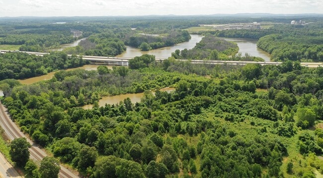
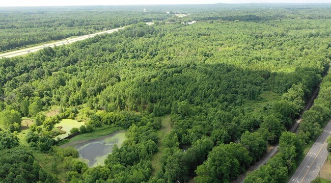
Property Record
2555 N Us Highway 29, Salisbury, NC 28144

Property Detail
2555 N Us Highway 29
048-006
176.30AC CALC
Industrialacreage
ROWAN
AE The base floodplain where base flood elevations are provided. AE Zones are now used on new format FIRMs instead of A1-A30 Zones.
North Carolina
2025
175.45 AC
2025
Rowan County
050800
Charlotte
8,010 SF
Charlotte-Concord-Gastonia, NC-SC
NEARBY LISTINGS FOR SALE OR LEASE
-
-
View all Salisbury listings for sale on LoopNet.com
DEMOGRAPHICS near 2555 N Us Highway 29
1 mile
3 mile
5 mile
2025 Total Population
244
7,077
24,585
2030 Population
258
7,494
25,903
Pop Growth 2025-2030
+ 5.74%
+ 5.89%
+ 5.36%
Average Age
42
42
42
2025 Total Households
97
2,805
9,875
HH Growth 2025-2030
+ 6.19%
+ 5.95%
+ 5.46%
Median Household Inc
$78,409
$69,350
$66,771
Avg Household Size
2.50
2.40
2.40
2025 Avg HH Vehicles
2.00
2.00
2.00
Median Home Value
$374,999
$244,598
$264,007
Median Year Built
1969
1974
1976
Nearby Places
Map Layers
Map Styles
 Street
 Aerial
Layers
 Traffic
 Biking
Places
Listings with unknown addresses are not visible on the map
- Restaurants
- Banks
- Shops
- Fitness
- Groceries
PUBLIC TRANSPORTATION
COMMUTER RAIL
Salisbury Station (Piedmont - North Carolina by Train (NC Train))
Drive
Walk
Distance
Salisbury Station (Piedmont - North Carolina by Train (NC Train))
12 min
5.7 mi
AIRPORT
Concord-Padgett Regional
Drive
Walk
Distance
Concord-Padgett Regional
46 min
36.8 mi
Freight Ports
Port of Wilmington
Drive
Walk
Distance
Port of Wilmington
267 min
223.5 mi
SALE & LEASE HISTORY
LISTING DATE
SALE/LEASE

Jul 26, 2017
For Sale
Jul 13, 2021
For Sale
Nearby Properties
Address
Land Use
TOTAL SIZE
Lot Size
Zoning
Address
Land Use
TOTAL SIZE
Lot Size
Zoning
708,972 SF
79.50 AC
Address
Land Use
TOTAL SIZE
Lot Size
Zoning
395,051 SF
263.20 AC
Address
Land Use
TOTAL SIZE
Lot Size
Zoning
212,046 SF
32.25 AC
Address
Land Use
TOTAL SIZE
Lot Size
Zoning
451,980 SF
60.67 AC
Address
Land Use
TOTAL SIZE
Lot Size
Zoning
92,101 SF
28.16 AC
R8:SINGLE
Address
Land Use
TOTAL SIZE
Lot Size
Zoning
29,875 SF
34.69 AC
I:MANUFACT
Address
Land Use
TOTAL SIZE
Lot Size
Zoning
86,632 SF
22.44 AC
Address
Land Use
TOTAL SIZE
Lot Size
Zoning
100,830 SF
51.38 AC
LI
Address
Land Use
TOTAL SIZE
Lot Size
Zoning
18,400 SF
332.07 AC
Address
Land Use
TOTAL SIZE
Lot Size
Zoning
7,048 SF
44.77 AC
Address
Land Use
TOTAL SIZE
Lot Size
Zoning
7,755 SF
60.61 AC
R8:SINGLE
Address
Land Use
TOTAL SIZE
Lot Size
Zoning
49,480 SF
5.64 AC
NB:NEIGHBO
Address
Land Use
TOTAL SIZE
Lot Size
Zoning
4,794 SF
4.02 AC
Address
Land Use
TOTAL SIZE
Lot Size
Zoning
156,000 SF
32.20 AC
I:MANUFACT
Address
Land Use
TOTAL SIZE
Lot Size
Zoning
100,000 SF
7.64 AC
I:MANUFACT
Address
Land Use
TOTAL SIZE
Lot Size
Zoning
4,794 SF
5.09 AC
LI
Address
Land Use
TOTAL SIZE
Lot Size
Zoning
1.17 AC
Address
Land Use
TOTAL SIZE
Lot Size
Zoning
7,230 SF
1.21 AC
HB:HIGHWAY
Address
Land Use
TOTAL SIZE
Lot Size
Zoning
11,299 SF
4.16 AC
HC
Address
Land Use
TOTAL SIZE
Lot Size
Zoning
9,131 SF
4.95 AC
Address
Land Use
TOTAL SIZE
Lot Size
Zoning
21,276 SF
7.10 AC
Address
Land Use
TOTAL SIZE
Lot Size
Zoning
203.29 AC
Address
Land Use
TOTAL SIZE
Lot Size
Zoning
62,500 SF
6.78 AC
I:MANUFACT
Address
Land Use
TOTAL SIZE
Lot Size
Zoning
83.79 AC
Address
Land Use
TOTAL SIZE
Lot Size
Zoning
4,480 SF
1.72 AC
Address
Land Use
TOTAL SIZE
Lot Size
Zoning
11,669 SF
7.74 AC
R6:TWO FAM
Address
Land Use
TOTAL SIZE
Lot Size
Zoning
7,501 SF
1.11 AC
R6:TWO FAM
Address
Land Use
TOTAL SIZE
Lot Size
Zoning
6,239 SF
1.16 AC
R6:TWO FAM
Address
Land Use
TOTAL SIZE
Lot Size
Zoning
5,652 SF
4 AC
OI
The World's #1 Commercial Real Estate Marketplace
Connect with us
© 2026 CoStar Group
The information above has been obtained from sources believed reliable. While we do not doubt its accuracy we have not verified it and make no guarantee, warranty or representation about it. It is your responsibility to independently confirm its accuracy and completeness. Any projections, opinions, assumptions, or estimates used are for example only and do not represent the current or future performance of the property. The value of this transaction to you depends on tax and other factors which should be evaluated by your tax, financial, and legal advisors. You and your advisors should conduct a careful, independent investigation of the property to determine to your satisfaction the suitability of the property for your needs.