No Photo
Property Record
2555 Ne Pine Island Rd, Cape Coral, FL 33909
NEARBY LISTINGS FOR SALE OR LEASE
-
-
View all Cape Coral listings for sale on LoopNet.com
Property Detail
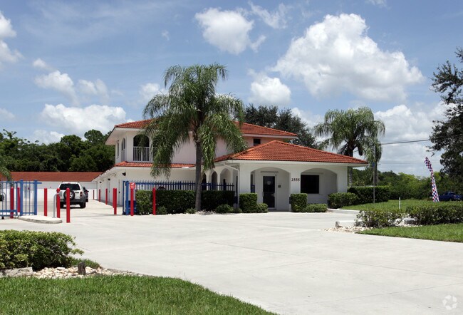
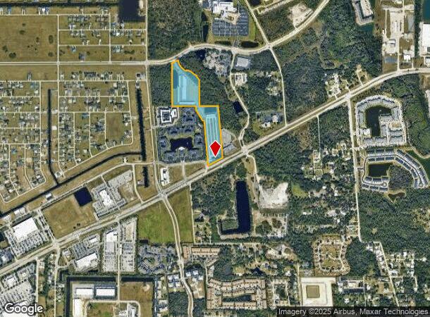
2555 Ne Pine Island Rd
Cape Coral-Fort Myers, FL
Pine Island Rd Corridor
04-44-24-C1-00012.0010
PARL IN NW 1/4 SEC 4 AND SW 1/4 SEC 33 AS DESC IN OR 2014 PG 3390 + OR 4709/1829 + OR 4709/1831 + INST #2017000234857
Warehouse
Lee
AE
Florida
12071C0266G
1
2024
6.61 AC
2025
Cape Coral
010203
Southwest Florida
212,616 SF
DEMOGRAPHICS near 2555 Ne Pine Island Rd
1 Mile
3 Mile
5 Mile
2024 Total Population
5,117
56,912
145,564
2029 Population
6,103
67,177
172,949
Pop Growth 2024-2029
+ 19.27%
+ 18.04%
+ 18.81%
Average Age
41
45
45
2024 Total Households
2,082
23,705
60,126
HH Growth 2024-2029
+ 18.88%
+ 17.52%
+ 18.36%
Median Household Inc
$41,458
$58,768
$56,951
Avg Household Size
2.40
2.30
2.30
2024 Avg HH Vehicles
1.00
2.00
2.00
Median Home Value
$188,539
$203,328
$221,041
Median Year Built
1997
1988
1990
Nearby Places
Map Layers
Map Styles
 Street
 Aerial
- Restaurants
- Banks
- Shops
- Fitness
- Groceries
PUBLIC TRANSPORTATION
AIRPORT
Southwest Florida International
DRIVE
WALK
Distance
Southwest Florida International
32 min
19.1 mi
Punta Gorda
DRIVE
WALK
Distance
Punta Gorda
31 min
21.5 mi
Freight Ports
Port Manatee
DRIVE
WALK
Distance
Port Manatee
111 min
93.1 mi
Nearby Properties
Address
Land Use
TOTAL SIZE
Lot Size
Zoning
Address
Land Use
TOTAL SIZE
Lot Size
Zoning
634,872 SF
43.30 AC
C1-D
Address
Land Use
TOTAL SIZE
Lot Size
Zoning
214,515 SF
30.60 AC
I-1
Address
Land Use
TOTAL SIZE
Lot Size
Zoning
485,271 SF
20.05 AC
CORR
Address
Land Use
TOTAL SIZE
Lot Size
Zoning
347,871 SF
29.40 AC
RML
Address
Land Use
TOTAL SIZE
Lot Size
Zoning
13.60 AC
CC
Address
Land Use
TOTAL SIZE
Lot Size
Zoning
339,525 SF
38.30 AC
R1BD
Address
Land Use
TOTAL SIZE
Lot Size
Zoning
333,938 SF
35.80 AC
C-1
Address
Land Use
TOTAL SIZE
Lot Size
Zoning
61,844 SF
7.31 AC
CC
Address
Land Use
TOTAL SIZE
Lot Size
Zoning
138,476 SF
4.11 AC
CORR
Address
Land Use
TOTAL SIZE
Lot Size
Zoning
451,348 SF
21.43 AC
CPD
Address
Land Use
TOTAL SIZE
Lot Size
Zoning
124,182 SF
13.30 AC
CORR
Address
Land Use
TOTAL SIZE
Lot Size
Zoning
124,101 SF
11.60 AC
C-1
Address
Land Use
TOTAL SIZE
Lot Size
Zoning
151,620 SF
19.97 AC
RM-2
Address
Land Use
TOTAL SIZE
Lot Size
Zoning
76,042 SF
7.50 AC
CORR
Address
Land Use
TOTAL SIZE
Lot Size
Zoning
82,478 SF
15.46 AC
CORR
Address
Land Use
TOTAL SIZE
Lot Size
Zoning
128,355 SF
19.24 AC
C-1
Address
Land Use
TOTAL SIZE
Lot Size
Zoning
112,356 SF
18.99 AC
AG-2
Address
Land Use
TOTAL SIZE
Lot Size
Zoning
109,404 SF
14.22 AC
AG-2
Address
Land Use
TOTAL SIZE
Lot Size
Zoning
51,478 SF
68.97 AC
C-2
Address
Land Use
TOTAL SIZE
Lot Size
Zoning
107,321 SF
7.80 AC
C-1A
Address
Land Use
TOTAL SIZE
Lot Size
Zoning
101,343 SF
8.06 AC
IL
Address
Land Use
TOTAL SIZE
Lot Size
Zoning
74,678 SF
8.97 AC
CPD
Address
Land Use
TOTAL SIZE
Lot Size
Zoning
92,632 SF
32 AC
R1BD
Address
Land Use
TOTAL SIZE
Lot Size
Zoning
10,377 SF
3.34 AC
RML
Address
Land Use
TOTAL SIZE
Lot Size
Zoning
141,571 SF
4.57 AC
C-1A
Address
Land Use
TOTAL SIZE
Lot Size
Zoning
222,159 SF
25.12 AC
CP-D
Address
Land Use
TOTAL SIZE
Lot Size
Zoning
81,160 SF
9.40 AC
CPD
Address
Land Use
TOTAL SIZE
Lot Size
Zoning
39,204 SF
5.89 AC
CORR
Address
Land Use
TOTAL SIZE
Lot Size
Zoning
197,353 SF
14 AC
VILL
The World's #1 Commercial Real Estate Marketplace
Connect with us
© 2025 CoStar Group
The information above has been obtained from sources believed reliable. While we do not doubt its accuracy we have not verified it and make no guarantee, warranty or representation about it. It is your responsibility to independently confirm its accuracy and completeness. Any projections, opinions, assumptions, or estimates used are for example only and do not represent the current or future performance of the property. The value of this transaction to you depends on tax and other factors which should be evaluated by your tax, financial, and legal advisors. You and your advisors should conduct a careful, independent investigation of the property to determine to your satisfaction the suitability of the property for your needs.