Property Record
2555 Packerland Dr, Green Bay, WI 54313


Save to a Folder
{{folder.Name}}
{{folder.ListingIds.length}} Properties
{{folder.ListingIds.length}} Property
Create a New Folder
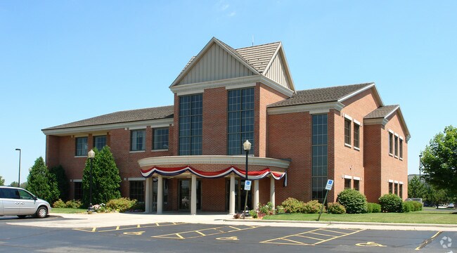
Property Detail
2555 Packerland Dr
Green Bay, WI
LOT 1 OF 35 CSM 142 MAP 5375 IN 1543968 BNG PRT OF PC 22 WSFR EX 2891410
VA-147
Brown
Commercialnec
Wisconsin
B and X Area of moderate flood hazard, usually the area between the limits of the 100-year and 500-year floods.
1
2025
2.36 AC
2025
Ashwaubenon
021302
Green Bay
NEARBY LISTINGS FOR SALE OR LEASE
DEMOGRAPHICS near 2555 Packerland Dr
1 mile
3 mile
5 mile
2025 Total Population
5,609
39,725
124,271
2030 Population
5,618
40,402
126,424
Pop Growth 2025-2030
+ 0.16%
+ 1.70%
+ 1.73%
Average Age
43
42
41
2025 Total Households
2,236
17,120
52,628
HH Growth 2025-2030
+ 0.18%
+ 1.85%
+ 1.81%
Median Household Inc
$103,090
$77,466
$72,996
Avg Household Size
2.50
2.30
2.30
2025 Avg HH Vehicles
2.00
2.00
2.00
Median Home Value
$277,758
$258,708
$249,759
Median Year Built
1977
1976
1973
Nearby Places
Map Layers
Map Styles
 Street
 Aerial
Layers
 Traffic
 Biking
Places
Listings with unknown addresses are not visible on the map
- Restaurants
- Banks
- Shops
- Fitness
- Groceries
PUBLIC TRANSPORTATION
AIRPORT
Green Bay/Austin Straubel International
Drive
Walk
Distance
Green Bay/Austin Straubel International
5 min
1.7 mi
Appleton International
Drive
Walk
Distance
Appleton International
44 min
34.6 mi
Nearby Properties
Address
Land Use
TOTAL SIZE
Lot Size
Zoning
Address
Land Use
TOTAL SIZE
Lot Size
Zoning
11.89 AC
Address
Land Use
TOTAL SIZE
Lot Size
Zoning
21.87 AC
Address
Land Use
TOTAL SIZE
Lot Size
Zoning
0.62 AC
Address
Land Use
TOTAL SIZE
Lot Size
Zoning
27.86 AC
Address
Land Use
TOTAL SIZE
Lot Size
Zoning
Address
Land Use
TOTAL SIZE
Lot Size
Zoning
25.31 AC
Address
Land Use
TOTAL SIZE
Lot Size
Zoning
Address
Land Use
TOTAL SIZE
Lot Size
Zoning
71.85 AC
Address
Land Use
TOTAL SIZE
Lot Size
Zoning
45.50 AC
Address
Land Use
TOTAL SIZE
Lot Size
Zoning
18.61 AC
Address
Land Use
TOTAL SIZE
Lot Size
Zoning
3.90 AC
Address
Land Use
TOTAL SIZE
Lot Size
Zoning
17,227 SF
3.13 AC
GI
Address
Land Use
TOTAL SIZE
Lot Size
Zoning
1.99 AC
Address
Land Use
TOTAL SIZE
Lot Size
Zoning
20.83 AC
Address
Land Use
TOTAL SIZE
Lot Size
Zoning
26.42 AC
Address
Land Use
TOTAL SIZE
Lot Size
Zoning
184,367 SF
10.34 AC
GI
Address
Land Use
TOTAL SIZE
Lot Size
Zoning
9.14 AC
Address
Land Use
TOTAL SIZE
Lot Size
Zoning
Address
Land Use
TOTAL SIZE
Lot Size
Zoning
Address
Land Use
TOTAL SIZE
Lot Size
Zoning
Address
Land Use
TOTAL SIZE
Lot Size
Zoning
2.11 AC
Address
Land Use
TOTAL SIZE
Lot Size
Zoning
2.98 AC
Address
Land Use
TOTAL SIZE
Lot Size
Zoning
5.94 AC
Address
Land Use
TOTAL SIZE
Lot Size
Zoning
17.66 AC
Address
Land Use
TOTAL SIZE
Lot Size
Zoning
16.74 AC
Address
Land Use
TOTAL SIZE
Lot Size
Zoning
13.58 AC
Address
Land Use
TOTAL SIZE
Lot Size
Zoning
27.20 AC
Address
Land Use
TOTAL SIZE
Lot Size
Zoning
15.41 AC
Address
Land Use
TOTAL SIZE
Lot Size
Zoning
6.34 AC
Address
Land Use
TOTAL SIZE
Lot Size
Zoning
1.65 AC
The World's #1 Commercial Real Estate Marketplace
Connect with us
© 2026 CoStar Group
The information above has been obtained from sources believed reliable. While we do not doubt its accuracy we have not verified it and make no guarantee, warranty or representation about it. It is your responsibility to independently confirm its accuracy and completeness. Any projections, opinions, assumptions, or estimates used are for example only and do not represent the current or future performance of the property. The value of this transaction to you depends on tax and other factors which should be evaluated by your tax, financial, and legal advisors. You and your advisors should conduct a careful, independent investigation of the property to determine to your satisfaction the suitability of the property for your needs.