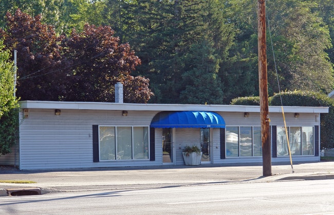
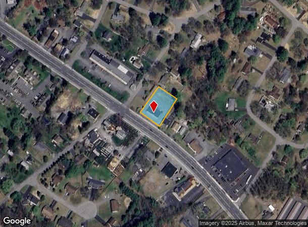
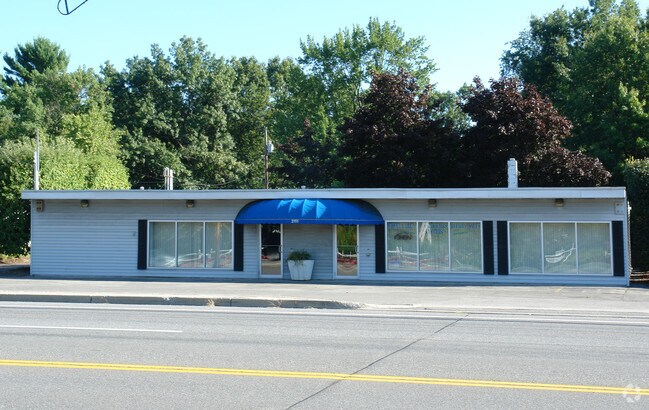
Property Record
2555 Western Ave, Altamont, NY 12009
NEARBY LISTINGS FOR SALE OR LEASE
-
-
View all Altamont listings for sale on LoopNet.com
Property Detail
2555 Western Ave
013089-039-011-0002-023-000-0000
Albany
Storesoffices
New York
X
23.000
36001C0158D
0.62 AC
2025
W Outer Albany County
2024
Albany/Schenectady/Troy
014616
Albany-Schenectady-Troy, NY
2,960 SF
DEMOGRAPHICS near 2555 Western Ave
1 Mile
3 Mile
5 Mile
2024 Total Population
4,169
22,189
72,525
2029 Population
4,174
22,103
73,317
Pop Growth 2024-2029
+ 0.12%
(0.39%)
+ 1.09%
Average Age
42
43
43
2024 Total Households
1,644
9,092
30,686
HH Growth 2024-2029
+ 0.18%
(0.32%)
+ 1.23%
Median Household Inc
$123,183
$98,816
$86,253
Avg Household Size
2.50
2.40
2.30
2024 Avg HH Vehicles
2.00
2.00
2.00
Median Home Value
$387,023
$328,826
$253,078
Median Year Built
1979
1979
1972
Nearby Places
- Restaurants
- Banks
- Shops
- Fitness
- Groceries
PUBLIC TRANSPORTATION
COMMUTER RAIL
DRIVE
WALK
Distance
17 min
9.6 mi
AIRPORT
Albany International
DRIVE
WALK
Distance
Albany International
23 min
12.0 mi
SALE & LEASE HISTORY
LISTING DATE
SALE/LEASE

Nov 16, 2022
For Sale
Nearby Properties
Address
Land Use
TOTAL SIZE
Lot Size
Zoning
Address
Land Use
TOTAL SIZE
Lot Size
Zoning
47,424 SF
37.60 AC
MR
Address
Land Use
TOTAL SIZE
Lot Size
Zoning
98.20 AC
LC
Address
Land Use
TOTAL SIZE
Lot Size
Zoning
353,075 SF
69.50 AC
R15
Address
Land Use
TOTAL SIZE
Lot Size
Zoning
172,800 SF
209.63 AC
IN
Address
Land Use
TOTAL SIZE
Lot Size
Zoning
80.10 AC
LC
Address
Land Use
TOTAL SIZE
Lot Size
Zoning
8,600 SF
14.80 AC
MR
Address
Land Use
TOTAL SIZE
Lot Size
Zoning
172,800 SF
272.81 AC
IN
Address
Land Use
TOTAL SIZE
Lot Size
Zoning
9,000 SF
10.32 AC
GB
Address
Land Use
TOTAL SIZE
Lot Size
Zoning
22,446 SF
11.30 AC
MR
Address
Land Use
TOTAL SIZE
Lot Size
Zoning
10,880 SF
13.50 AC
TH
Address
Land Use
TOTAL SIZE
Lot Size
Zoning
75,790 SF
19.23 AC
RO40
Address
Land Use
TOTAL SIZE
Lot Size
Zoning
161,797 SF
13.69 AC
GB
Address
Land Use
TOTAL SIZE
Lot Size
Zoning
19,968 SF
12 AC
MR
Address
Land Use
TOTAL SIZE
Lot Size
Zoning
78,326 SF
27.47 AC
R40
Address
Land Use
TOTAL SIZE
Lot Size
Zoning
14,436 SF
13.20 AC
MR
Address
Land Use
TOTAL SIZE
Lot Size
Zoning
45 AC
LC
Address
Land Use
TOTAL SIZE
Lot Size
Zoning
131,716 SF
65.09 AC
RO40
Address
Land Use
TOTAL SIZE
Lot Size
Zoning
183,140 SF
9.85 AC
CM
Address
Land Use
TOTAL SIZE
Lot Size
Zoning
86,049 SF
17.10 AC
RO30
Address
Land Use
TOTAL SIZE
Lot Size
Zoning
16,232 SF
285.90 AC
RO40
Address
Land Use
TOTAL SIZE
Lot Size
Zoning
121,137 SF
5.92 AC
PUD
Address
Land Use
TOTAL SIZE
Lot Size
Zoning
8,832 SF
6.40 AC
MR
Address
Land Use
TOTAL SIZE
Lot Size
Zoning
89,640 SF
6 AC
MR
Address
Land Use
TOTAL SIZE
Lot Size
Zoning
74,167 SF
8.80 AC
PUD
Address
Land Use
TOTAL SIZE
Lot Size
Zoning
7,856 SF
14.30 AC
MR
Address
Land Use
TOTAL SIZE
Lot Size
Zoning
20,630 SF
12.99 AC
MR*
Address
Land Use
TOTAL SIZE
Lot Size
Zoning
11,516 SF
131 AC
RA3
Address
Land Use
TOTAL SIZE
Lot Size
Zoning
30.20 AC
LC
Address
Land Use
TOTAL SIZE
Lot Size
Zoning
68,000 SF
11.20 AC
TH
Address
Land Use
TOTAL SIZE
Lot Size
Zoning
6,889 SF
284.30 AC
F
The World's #1 Commercial Real Estate Marketplace
Connect with us
© 2025 CoStar Group
The information above has been obtained from sources believed reliable. While we do not doubt its accuracy we have not verified it and make no guarantee, warranty or representation about it. It is your responsibility to independently confirm its accuracy and completeness. Any projections, opinions, assumptions, or estimates used are for example only and do not represent the current or future performance of the property. The value of this transaction to you depends on tax and other factors which should be evaluated by your tax, financial, and legal advisors. You and your advisors should conduct a careful, independent investigation of the property to determine to your satisfaction the suitability of the property for your needs.