Property Record
2556 W Shore Rd, Warwick, RI 02889
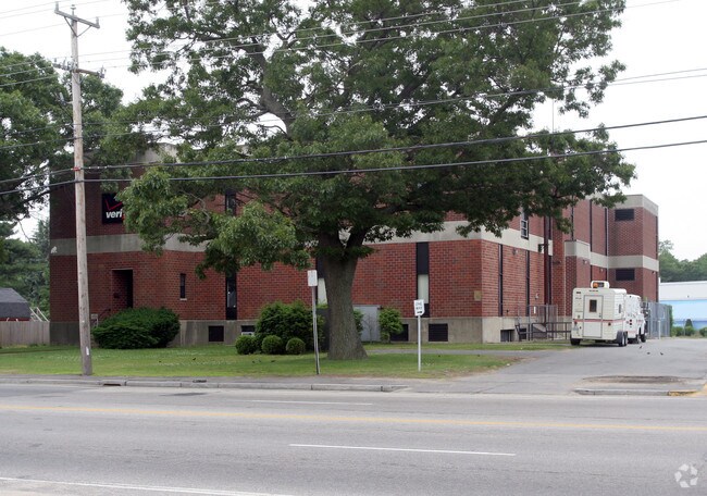

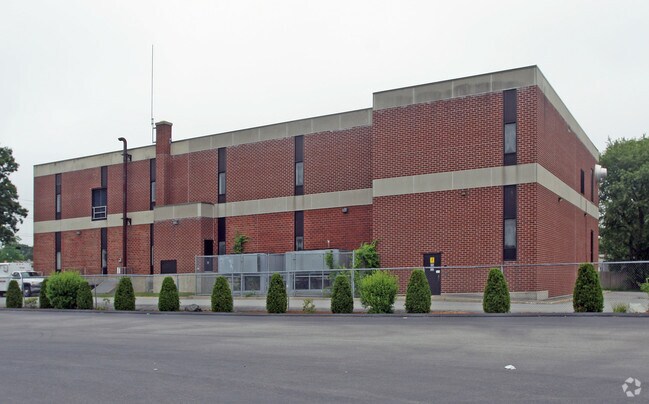
Property Detail
2556 W Shore Rd
Utilities
Kent
GB
Rhode Island
B and X Area of moderate flood hazard, usually the area between the limits of the 100-year and 500-year floods.
0.68 AC
2025
Warwick
2025
Providence
021700
Providence-Warwick, RI-MA
22,822 SF
WARW-000362-000439-000000
NEARBY LISTINGS FOR SALE OR LEASE
DEMOGRAPHICS near 2556 W Shore Rd
1 mile
3 mile
5 mile
2025 Total Population
10,992
57,477
134,133
2030 Population
11,137
58,104
136,161
Pop Growth 2025-2030
+ 1.32%
+ 1.09%
+ 1.51%
Average Age
43
44
44
2025 Total Households
4,541
24,650
57,656
HH Growth 2025-2030
+ 1.37%
+ 1.14%
+ 1.53%
Median Household Inc
$99,213
$94,063
$91,497
Avg Household Size
2.30
2.30
2.20
2025 Avg HH Vehicles
2.00
2.00
2.00
Median Home Value
$323,508
$356,547
$373,393
Median Year Built
1961
1959
1960
Nearby Places
Map Layers
Map Styles
 Street
 Aerial
Layers
 Traffic
 Biking
Places
Listings with unknown addresses are not visible on the map
- Restaurants
- Banks
- Shops
- Fitness
- Groceries
PUBLIC TRANSPORTATION
COMMUTER RAIL
Drive
Walk
Distance
6 min
3.2 mi
Providence (Providence/Stoughton Line - Massachusetts Bay Transportation Authority Commuter Rail (Purple Line))
Drive
Walk
Distance
Providence (Providence/Stoughton Line - Massachusetts Bay Transportation Authority Commuter Rail (Purple Line))
19 min
9.9 mi
AIRPORT
Rhode Island Tf Green International
Drive
Walk
Distance
Rhode Island Tf Green International
11 min
4.0 mi
Freight Ports
Port of Davisville, RI
Drive
Walk
Distance
Port of Davisville, RI
26 min
14.4 mi
Nearby Properties
Address
Land Use
TOTAL SIZE
Lot Size
Zoning
Address
Land Use
TOTAL SIZE
Lot Size
Zoning
6,640 SF
0.01 AC
A10
Address
Land Use
TOTAL SIZE
Lot Size
Zoning
40,385 SF
70 AC
A40
Address
Land Use
TOTAL SIZE
Lot Size
Zoning
228,067 SF
30.74 AC
A7
Address
Land Use
TOTAL SIZE
Lot Size
Zoning
485,238 SF
2.05 AC
GB
Address
Land Use
TOTAL SIZE
Lot Size
Zoning
6,702 SF
49.97 AC
GI
Address
Land Use
TOTAL SIZE
Lot Size
Zoning
517,743 SF
3.55 AC
GI
Address
Land Use
TOTAL SIZE
Lot Size
Zoning
491,496 SF
46.72 AC
LI
Address
Land Use
TOTAL SIZE
Lot Size
Zoning
247,671 SF
10.78 AC
A7
Address
Land Use
TOTAL SIZE
Lot Size
Zoning
100,638 SF
6.80 AC
GB
Address
Land Use
TOTAL SIZE
Lot Size
Zoning
135,317 SF
27.16 AC
A10
Address
Land Use
TOTAL SIZE
Lot Size
Zoning
139,256 SF
29.40 AC
GB
Address
Land Use
TOTAL SIZE
Lot Size
Zoning
243,057 SF
9.59 AC
GB
Address
Land Use
TOTAL SIZE
Lot Size
Zoning
157,486 SF
13.09 AC
A7
Address
Land Use
TOTAL SIZE
Lot Size
Zoning
294,355 SF
19.51 AC
Address
Land Use
TOTAL SIZE
Lot Size
Zoning
278,684 SF
1.39 AC
GB
Address
Land Use
TOTAL SIZE
Lot Size
Zoning
65,646 SF
5.60 AC
Address
Land Use
TOTAL SIZE
Lot Size
Zoning
73,193 SF
19.87 AC
A10
Address
Land Use
TOTAL SIZE
Lot Size
Zoning
99,177 SF
LI
Address
Land Use
TOTAL SIZE
Lot Size
Zoning
19,584 SF
A10
Address
Land Use
TOTAL SIZE
Lot Size
Zoning
120,000 SF
6.14 AC
O
Address
Land Use
TOTAL SIZE
Lot Size
Zoning
24,865 SF
A7
Address
Land Use
TOTAL SIZE
Lot Size
Zoning
4,288 SF
10.23 AC
GB
Address
Land Use
TOTAL SIZE
Lot Size
Zoning
103,020 SF
2.29 AC
GI
Address
Land Use
TOTAL SIZE
Lot Size
Zoning
307,498 SF
7.15 AC
GI
Address
Land Use
TOTAL SIZE
Lot Size
Zoning
18,876 SF
44.45 AC
A7
Address
Land Use
TOTAL SIZE
Lot Size
Zoning
600,771 SF
30.33 AC
Address
Land Use
TOTAL SIZE
Lot Size
Zoning
135,991 SF
3.73 AC
GB
Address
Land Use
TOTAL SIZE
Lot Size
Zoning
48,800 SF
78.50 AC
A15
Address
Land Use
TOTAL SIZE
Lot Size
Zoning
12,240 SF
A10
Address
Land Use
TOTAL SIZE
Lot Size
Zoning
3,987 SF
5.99 AC
GB
The World's #1 Commercial Real Estate Marketplace
Connect with us
© 2026 CoStar Group
The information above has been obtained from sources believed reliable. While we do not doubt its accuracy we have not verified it and make no guarantee, warranty or representation about it. It is your responsibility to independently confirm its accuracy and completeness. Any projections, opinions, assumptions, or estimates used are for example only and do not represent the current or future performance of the property. The value of this transaction to you depends on tax and other factors which should be evaluated by your tax, financial, and legal advisors. You and your advisors should conduct a careful, independent investigation of the property to determine to your satisfaction the suitability of the property for your needs.