Property Record
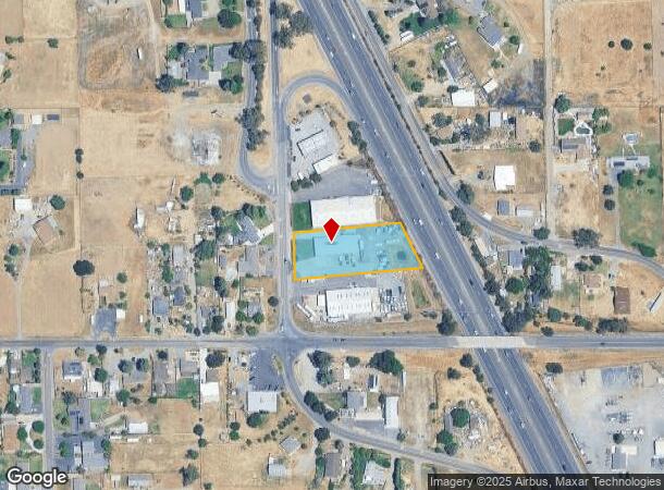
25560 N St Rt 99 East Frontage Rd, Acampo, CA 95220
NEARBY LISTINGS FOR SALE OR LEASE
-
-
View all Acampo listings for sale on LoopNet.com
Property Detail
25560 N St Rt 99 East Frontage Rd
Stockton-Lodi, CA
Forest Lake Farm Lands
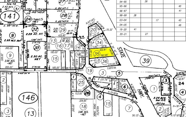
005-141-35
92-FM PT OF 005-141-25/PT TO 35/36 PER PM 17-126
Autorepair
San Joaquin
X
California
06067C0607J
7
2025
1 AC
2025
Lodi
004600
Stockton/Modesto
6,000 SF
DEMOGRAPHICS near 25560 N St Rt 99 East Frontage Rd
1 Mile
3 Mile
5 Mile
2024 Total Population
1,512
8,307
36,434
2029 Population
1,539
8,407
36,845
Pop Growth 2024-2029
+ 1.79%
+ 1.20%
+ 1.13%
Average Age
41
39
40
2024 Total Households
498
2,644
12,032
HH Growth 2024-2029
+ 1.81%
+ 1.21%
+ 1.20%
Median Household Inc
$86,895
$69,785
$89,127
Avg Household Size
3.00
3.10
3.00
2024 Avg HH Vehicles
3.00
3.00
2.00
Median Home Value
$738,351
$482,597
$489,260
Median Year Built
1972
1981
1989
Nearby Places
Map Layers
Map Styles
 Street
 Aerial
- Restaurants
- Banks
- Shops
- Fitness
- Groceries
PUBLIC TRANSPORTATION
COMMUTER RAIL
DRIVE
WALK
Distance
10 min
6.9 mi
AIRPORT
Stockton Metro
DRIVE
WALK
Distance
Stockton Metro
32 min
25.2 mi
Sacramento International
DRIVE
WALK
Distance
Sacramento International
53 min
40.8 mi
Freight Ports
Port of Stockton
DRIVE
WALK
Distance
Port of Stockton
31 min
23.7 mi
Nearby Properties
Address
Land Use
TOTAL SIZE
Lot Size
Zoning
Address
Land Use
TOTAL SIZE
Lot Size
Zoning
30,176 SF
41.38 AC
AG40
Address
Land Use
TOTAL SIZE
Lot Size
Zoning
77,052 SF
0.93 AC
DC
Address
Land Use
TOTAL SIZE
Lot Size
Zoning
78.99 AC
AG40
Address
Land Use
TOTAL SIZE
Lot Size
Zoning
46,376 SF
4.18 AC
C
Address
Land Use
TOTAL SIZE
Lot Size
Zoning
3,000 SF
11.20 AC
IT
Address
Land Use
TOTAL SIZE
Lot Size
Zoning
52,000 SF
3.28 AC
C
Address
Land Use
TOTAL SIZE
Lot Size
Zoning
1,456 SF
143.92 AC
IW
Address
Land Use
TOTAL SIZE
Lot Size
Zoning
12,804 SF
9.89 AC
PQ
Address
Land Use
TOTAL SIZE
Lot Size
Zoning
38.12 AC
AG40
Address
Land Use
TOTAL SIZE
Lot Size
Zoning
2,630 SF
44.64 AC
AG40
Address
Land Use
TOTAL SIZE
Lot Size
Zoning
32,196 SF
2.89 AC
C
Address
Land Use
TOTAL SIZE
Lot Size
Zoning
30,150 SF
2.13 AC
C
Address
Land Use
TOTAL SIZE
Lot Size
Zoning
33.68 AC
R1C OS
Address
Land Use
TOTAL SIZE
Lot Size
Zoning
118.96 AC
PF
Address
Land Use
TOTAL SIZE
Lot Size
Zoning
16,516 SF
1.33 AC
C
Address
Land Use
TOTAL SIZE
Lot Size
Zoning
6,464 SF
0.64 AC
HC
Address
Land Use
TOTAL SIZE
Lot Size
Zoning
2,745 SF
39.81 AC
AG40
Address
Land Use
TOTAL SIZE
Lot Size
Zoning
7,775 SF
1.51 AC
C
Address
Land Use
TOTAL SIZE
Lot Size
Zoning
1.58 AC
R2
Address
Land Use
TOTAL SIZE
Lot Size
Zoning
4,761 SF
77.90 AC
AG40
Address
Land Use
TOTAL SIZE
Lot Size
Zoning
1,818 SF
36.66 AC
Address
Land Use
TOTAL SIZE
Lot Size
Zoning
32,424 SF
0.89 AC
DC
Address
Land Use
TOTAL SIZE
Lot Size
Zoning
13,960 SF
1.63 AC
HC
Address
Land Use
TOTAL SIZE
Lot Size
Zoning
9.95 AC
HC
Address
Land Use
TOTAL SIZE
Lot Size
Zoning
79.64 AC
AG40
Address
Land Use
TOTAL SIZE
Lot Size
Zoning
6,640 SF
0.53 AC
DC
Address
Land Use
TOTAL SIZE
Lot Size
Zoning
95.43 AC
OS R2 R1C
Address
Land Use
TOTAL SIZE
Lot Size
Zoning
7,440 SF
0.53 AC
C
Address
Land Use
TOTAL SIZE
Lot Size
Zoning
166.47 AC
AG40
Address
Land Use
TOTAL SIZE
Lot Size
Zoning
4,910 SF
0.61 AC
C
The World's #1 Commercial Real Estate Marketplace
Connect with us
© 2026 CoStar Group
The information above has been obtained from sources believed reliable. While we do not doubt its accuracy we have not verified it and make no guarantee, warranty or representation about it. It is your responsibility to independently confirm its accuracy and completeness. Any projections, opinions, assumptions, or estimates used are for example only and do not represent the current or future performance of the property. The value of this transaction to you depends on tax and other factors which should be evaluated by your tax, financial, and legal advisors. You and your advisors should conduct a careful, independent investigation of the property to determine to your satisfaction the suitability of the property for your needs.