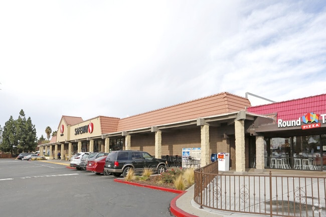
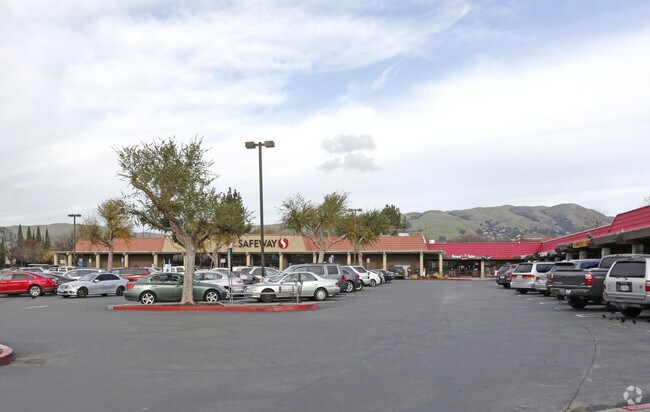
Property Record
2558 Berryessa Rd, San Jose, CA 95132

NEARBY LISTINGS FOR SALE OR LEASE
Property Detail
2558 Berryessa Rd
Regionalshoppingcenterormallwithanchorstore
Santa Clara
X
California
06085C0088J
3.35 AC
2024
San Jose-Berryessa
2025
South Bay/San Jose
504307
San Jose-Sunnyvale-Santa Clara, CA
31,500 SF
591-01-040
DEMOGRAPHICS near 2558 Berryessa Rd
1 Mile
3 Mile
5 Mile
2024 Total Population
29,690
195,900
427,152
2029 Population
28,408
187,399
410,161
Pop Growth 2024-2029
(4.32%)
(4.34%)
(3.98%)
Average Age
41
39
38
2024 Total Households
8,628
58,008
131,828
HH Growth 2024-2029
(4.61%)
(4.52%)
(4.02%)
Median Household Inc
$146,257
$129,253
$124,770
Avg Household Size
3.30
3.20
3.00
2024 Avg HH Vehicles
2.00
2.00
2.00
Median Home Value
$1,075,575
$1,019,084
$988,382
Median Year Built
1976
1977
1978
Nearby Places
Map Layers
Map Styles
 Street
 Aerial
- Restaurants
- Banks
- Shops
- Fitness
- Groceries
PUBLIC TRANSPORTATION
TRANSIT/SUBWAY
Berryessa Station (Alum Rock - Santa Teresa Line - Santa Clara VTA Light Rail)
DRIVE
WALK
Distance
Berryessa Station (Alum Rock - Santa Teresa Line - Santa Clara VTA Light Rail)
1 min
6 min
0.3 mi
Berryessa Station (Mountain View - Alum Rock - VTA)
DRIVE
WALK
Distance
Berryessa Station (Mountain View - Alum Rock - VTA)
1 min
7 min
0.4 mi
Penitencia Creek Station (Alum Rock - Santa Teresa Line - Santa Clara VTA Light Rail)
DRIVE
WALK
Distance
Penitencia Creek Station (Alum Rock - Santa Teresa Line - Santa Clara VTA Light Rail)
2 min
11 min
0.6 mi
Penitencia Creek Station (Mountain View - Alum Rock - VTA)
DRIVE
WALK
Distance
Penitencia Creek Station (Mountain View - Alum Rock - VTA)
2 min
13 min
0.7 mi
Hostetter Station (Mountain View - Alum Rock - VTA)
DRIVE
WALK
Distance
Hostetter Station (Mountain View - Alum Rock - VTA)
3 min
18 min
0.9 mi
COMMUTER RAIL
College Park (Caltrain - Caltrain (Caltrain))
DRIVE
WALK
Distance
College Park (Caltrain - Caltrain (Caltrain))
10 min
4.7 mi
College Park Caltrain Station Southbound (Local Weekday - Caltrain (Caltrain))
DRIVE
WALK
Distance
College Park Caltrain Station Southbound (Local Weekday - Caltrain (Caltrain))
11 min
5.0 mi
AIRPORT
Norman Y Mineta San Jose International
DRIVE
WALK
Distance
Norman Y Mineta San Jose International
12 min
6.2 mi
Freight Ports
Port of Redwood City
DRIVE
WALK
Distance
Port of Redwood City
33 min
24.3 mi
Nearby Properties
Address
Land Use
TOTAL SIZE
Lot Size
Zoning
Address
Land Use
TOTAL SIZE
Lot Size
Zoning
74,528 SF
9.26 AC
TEC
Address
Land Use
TOTAL SIZE
Lot Size
Zoning
1,282,514 SF
99.02 AC
C2-S
Address
Land Use
TOTAL SIZE
Lot Size
Zoning
33.32 AC
R140
Address
Land Use
TOTAL SIZE
Lot Size
Zoning
503,840 SF
5.02 AC
MXD2
Address
Land Use
TOTAL SIZE
Lot Size
Zoning
328,189 SF
4.01 AC
R3
Address
Land Use
TOTAL SIZE
Lot Size
Zoning
3.72 AC
M2S
Address
Land Use
TOTAL SIZE
Lot Size
Zoning
505,150 SF
35.68 AC
CIC
Address
Land Use
TOTAL SIZE
Lot Size
Zoning
4.56 AC
M2
Address
Land Use
TOTAL SIZE
Lot Size
Zoning
366,149 SF
2.98 AC
R3
Address
Land Use
TOTAL SIZE
Lot Size
Zoning
3.74 AC
APD
Address
Land Use
TOTAL SIZE
Lot Size
Zoning
143,242 SF
28.95 AC
C
Address
Land Use
TOTAL SIZE
Lot Size
Zoning
2.55 AC
MXD2
Address
Land Use
TOTAL SIZE
Lot Size
Zoning
6.04 AC
R5-S
Address
Land Use
TOTAL SIZE
Lot Size
Zoning
239,340 SF
2.32 AC
M2
Address
Land Use
TOTAL SIZE
Lot Size
Zoning
230,946 SF
2.86 AC
I
Address
Land Use
TOTAL SIZE
Lot Size
Zoning
270,526 SF
2.29 AC
MXD2
Address
Land Use
TOTAL SIZE
Lot Size
Zoning
192,026 SF
12.64 AC
IP
Address
Land Use
TOTAL SIZE
Lot Size
Zoning
2.78 AC
APD
Address
Land Use
TOTAL SIZE
Lot Size
Zoning
3.34 AC
M2
Address
Land Use
TOTAL SIZE
Lot Size
Zoning
237,570 SF
23.18 AC
I
Address
Land Use
TOTAL SIZE
Lot Size
Zoning
111,045 SF
9.88 AC
IP
Address
Land Use
TOTAL SIZE
Lot Size
Zoning
137,913 SF
56.18 AC
M25
Address
Land Use
TOTAL SIZE
Lot Size
Zoning
606,482 SF
15.54 AC
R-1-8
Address
Land Use
TOTAL SIZE
Lot Size
Zoning
251,101 SF
2.76 AC
04E
Address
Land Use
TOTAL SIZE
Lot Size
Zoning
168,645 SF
2.97 AC
APD
Address
Land Use
TOTAL SIZE
Lot Size
Zoning
287,858 SF
9.10 AC
I
Address
Land Use
TOTAL SIZE
Lot Size
Zoning
153,024 SF
8.11 AC
R3BPD
Address
Land Use
TOTAL SIZE
Lot Size
Zoning
116,044 SF
7 AC
C3PD
Address
Land Use
TOTAL SIZE
Lot Size
Zoning
79,508 SF
5 AC
IP
Address
Land Use
TOTAL SIZE
Lot Size
Zoning
1.98 AC
R4
The World's #1 Commercial Real Estate Marketplace
Connect with us
© 2026 CoStar Group
The information above has been obtained from sources believed reliable. While we do not doubt its accuracy we have not verified it and make no guarantee, warranty or representation about it. It is your responsibility to independently confirm its accuracy and completeness. Any projections, opinions, assumptions, or estimates used are for example only and do not represent the current or future performance of the property. The value of this transaction to you depends on tax and other factors which should be evaluated by your tax, financial, and legal advisors. You and your advisors should conduct a careful, independent investigation of the property to determine to your satisfaction the suitability of the property for your needs.