Property Record
2559 37Th Ave, Columbus, NE 68601
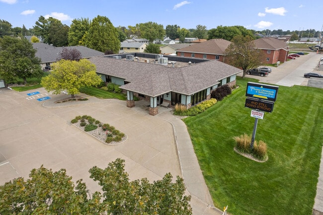


This Property Is For Sale
Property Detail
2559 37Th Ave
710124824
S180' BLK B WALLIN S D OF RANDALL 2ND COLUMBUS
Medicalbuilding
PLATTE
03-COMMERC
Nebraska
2025
1.02 AC
2025
Nebraska Area
965302
Other Market Areas
6,076 SF
Columbus, NE
NEARBY LISTINGS FOR SALE OR LEASE
DEMOGRAPHICS near 2559 37Th Ave
1 mile
3 mile
5 mile
2025 Total Population
11,481
27,044
29,266
2030 Population
11,949
28,211
30,540
Pop Growth 2025-2030
+ 4.08%
+ 4.32%
+ 4.35%
Average Age
40
39
39
2025 Total Households
4,693
10,545
11,363
HH Growth 2025-2030
+ 4.18%
+ 4.37%
+ 4.40%
Median Household Inc
$67,222
$71,082
$71,828
Avg Household Size
2.40
2.50
2.50
2025 Avg HH Vehicles
2.00
2.00
2.00
Median Home Value
$221,465
$219,620
$222,402
Median Year Built
1972
1972
1972
Nearby Places
Map Layers
Map Styles
 Street
 Aerial
Layers
 Traffic
 Biking
Places
Listings with unknown addresses are not visible on the map
- Restaurants
- Banks
- Shops
- Fitness
- Groceries
Nearby Properties
Address
Land Use
TOTAL SIZE
Lot Size
Zoning
Address
Land Use
TOTAL SIZE
Lot Size
Zoning
124,771 SF
1 AC
04-INDUSTR
Address
Land Use
TOTAL SIZE
Lot Size
Zoning
2,944 SF
7.37 AC
03-COMMERC
Address
Land Use
TOTAL SIZE
Lot Size
Zoning
222,895 SF
1 AC
03-COMMERC
Address
Land Use
TOTAL SIZE
Lot Size
Zoning
121,000 SF
1 AC
04-INDUSTR
Address
Land Use
TOTAL SIZE
Lot Size
Zoning
161,640 SF
15 AC
03-COMMERC
Address
Land Use
TOTAL SIZE
Lot Size
Zoning
13,688 SF
1 AC
02-MULTI-F
Address
Land Use
TOTAL SIZE
Lot Size
Zoning
68,614 SF
1 AC
03-COMMERC
Address
Land Use
TOTAL SIZE
Lot Size
Zoning
38,519 SF
3.75 AC
03-COMMERC
Address
Land Use
TOTAL SIZE
Lot Size
Zoning
57,967 SF
5.96 AC
03-COMMERC
Address
Land Use
TOTAL SIZE
Lot Size
Zoning
76,800 SF
2.04 AC
03-COMMERC
Address
Land Use
TOTAL SIZE
Lot Size
Zoning
64,860 SF
2.92 AC
03-COMMERC
Address
Land Use
TOTAL SIZE
Lot Size
Zoning
8,364 SF
1 AC
02-MULTI-F
Address
Land Use
TOTAL SIZE
Lot Size
Zoning
34,885 SF
18.25 AC
03-COMMERC
Address
Land Use
TOTAL SIZE
Lot Size
Zoning
70,212 SF
6.81 AC
03-COMMERC
Address
Land Use
TOTAL SIZE
Lot Size
Zoning
63,927 SF
5.71 AC
04-INDUSTR
Address
Land Use
TOTAL SIZE
Lot Size
Zoning
90,056 SF
03-COMMERC
Address
Land Use
TOTAL SIZE
Lot Size
Zoning
16,845 SF
1 AC
03-COMMERC
Address
Land Use
TOTAL SIZE
Lot Size
Zoning
23,664 SF
1 AC
02-MULTI-F
Address
Land Use
TOTAL SIZE
Lot Size
Zoning
46,135 SF
16.30 AC
04-INDUSTR
Address
Land Use
TOTAL SIZE
Lot Size
Zoning
42,980 SF
1 AC
03-COMMERC
Address
Land Use
TOTAL SIZE
Lot Size
Zoning
20,800 SF
3.06 AC
03-COMMERC
Address
Land Use
TOTAL SIZE
Lot Size
Zoning
28,891 SF
1 AC
03-COMMERC
Address
Land Use
TOTAL SIZE
Lot Size
Zoning
50,864 SF
1.79 AC
03-COMMERC
Address
Land Use
TOTAL SIZE
Lot Size
Zoning
104.75 AC
03-COMMERC
Address
Land Use
TOTAL SIZE
Lot Size
Zoning
68,614 SF
10.01 AC
03-COMMERC
Address
Land Use
TOTAL SIZE
Lot Size
Zoning
85,182 SF
1 AC
03-COMMERC
Address
Land Use
TOTAL SIZE
Lot Size
Zoning
54,466 SF
1 AC
03-COMMERC
Address
Land Use
TOTAL SIZE
Lot Size
Zoning
17,863 SF
1.08 AC
03-COMMERC
The World's #1 Commercial Real Estate Marketplace
Connect with us
© 2026 CoStar Group
The information above has been obtained from sources believed reliable. While we do not doubt its accuracy we have not verified it and make no guarantee, warranty or representation about it. It is your responsibility to independently confirm its accuracy and completeness. Any projections, opinions, assumptions, or estimates used are for example only and do not represent the current or future performance of the property. The value of this transaction to you depends on tax and other factors which should be evaluated by your tax, financial, and legal advisors. You and your advisors should conduct a careful, independent investigation of the property to determine to your satisfaction the suitability of the property for your needs.