Property Record
2559 Dallas Hwy Sw, Marietta, GA 30064
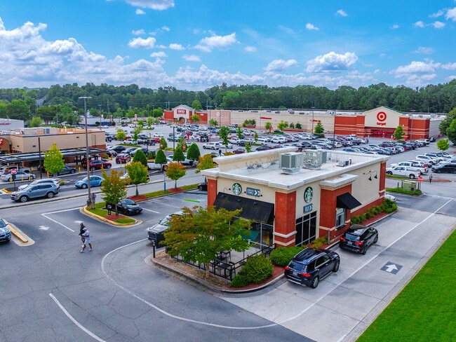
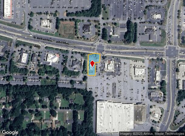
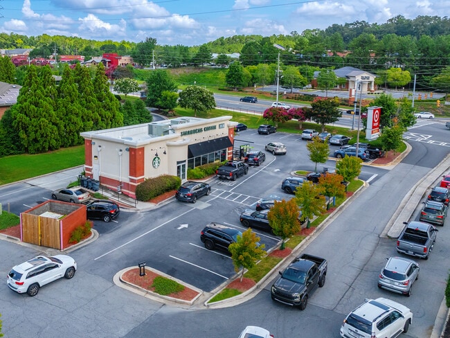
This Property Is For Sale
NEARBY LISTINGS FOR SALE OR LEASE
Property Detail
2559 Dallas Hwy Sw
Restaurantdrivein
Cobb
X
Georgia
13067C0084G
0.59 AC
2025
Powder Spring/Austell
2025
Atlanta
030262
Atlanta-Sandy Springs-Roswell, GA
1,479 SF
19-0027-0-016-0
DEMOGRAPHICS near 2559 Dallas Hwy Sw
1 Mile
3 Mile
5 Mile
2024 Total Population
5,184
42,491
152,222
2029 Population
5,322
43,109
155,087
Pop Growth 2024-2029
+ 2.66%
+ 1.45%
+ 1.88%
Average Age
42
42
40
2024 Total Households
1,811
14,968
55,389
HH Growth 2024-2029
+ 2.71%
+ 1.46%
+ 1.98%
Median Household Inc
$118,804
$121,632
$93,829
Avg Household Size
2.80
2.80
2.70
2024 Avg HH Vehicles
2.00
2.00
2.00
Median Home Value
$408,960
$390,766
$360,249
Median Year Built
1996
1992
1992
Nearby Places
Map Layers
Map Styles
 Street
 Aerial
- Restaurants
- Banks
- Shops
- Fitness
- Groceries
PUBLIC TRANSPORTATION
AIRPORT
Hartsfield - Jackson Atlanta International
DRIVE
WALK
Distance
Hartsfield - Jackson Atlanta International
50 min
33.7 mi
Freight Ports
Georgia Ports - Savannah
DRIVE
WALK
Distance
Georgia Ports - Savannah
313 min
273.0 mi
Nearby Properties
Address
Land Use
TOTAL SIZE
Lot Size
Zoning
Address
Land Use
TOTAL SIZE
Lot Size
Zoning
264,394 SF
27.59 AC
NRC
Address
Land Use
TOTAL SIZE
Lot Size
Zoning
3,240 SF
24.28 AC
RSL
Address
Land Use
TOTAL SIZE
Lot Size
Zoning
82,012 SF
9.53 AC
Address
Land Use
TOTAL SIZE
Lot Size
Zoning
180,508 SF
21.88 AC
RM-8
Address
Land Use
TOTAL SIZE
Lot Size
Zoning
81,639 SF
15.82 AC
NRC
Address
Land Use
TOTAL SIZE
Lot Size
Zoning
77,699 SF
3.84 AC
O&I/WS
Address
Land Use
TOTAL SIZE
Lot Size
Zoning
97,836 SF
8.88 AC
NRC/CRC
Address
Land Use
TOTAL SIZE
Lot Size
Zoning
53.78 AC
R20
Address
Land Use
TOTAL SIZE
Lot Size
Zoning
108,435 SF
13.69 AC
NRC
Address
Land Use
TOTAL SIZE
Lot Size
Zoning
105,892 SF
14.07 AC
NRC/WS
Address
Land Use
TOTAL SIZE
Lot Size
Zoning
9.86 AC
RSL
Address
Land Use
TOTAL SIZE
Lot Size
Zoning
126,108 SF
7.71 AC
PRD MF
Address
Land Use
TOTAL SIZE
Lot Size
Zoning
2,430 SF
9.17 AC
RSL
Address
Land Use
TOTAL SIZE
Lot Size
Zoning
134,362 SF
23.12 AC
CRC/WS
Address
Land Use
TOTAL SIZE
Lot Size
Zoning
93,128 SF
9.45 AC
CRC
Address
Land Use
TOTAL SIZE
Lot Size
Zoning
7,095 SF
7.93 AC
OI
Address
Land Use
TOTAL SIZE
Lot Size
Zoning
63,696 SF
159.75 AC
R-20
Address
Land Use
TOTAL SIZE
Lot Size
Zoning
1,524 SF
51.95 AC
R30
Address
Land Use
TOTAL SIZE
Lot Size
Zoning
124,231 SF
10.25 AC
CRC
Address
Land Use
TOTAL SIZE
Lot Size
Zoning
57,471 SF
7.41 AC
CRC
Address
Land Use
TOTAL SIZE
Lot Size
Zoning
116,500 SF
23.77 AC
CRC/LRO
Address
Land Use
TOTAL SIZE
Lot Size
Zoning
41,412 SF
7.35 AC
NRC
Address
Land Use
TOTAL SIZE
Lot Size
Zoning
99,900 SF
2.69 AC
GC
Address
Land Use
TOTAL SIZE
Lot Size
Zoning
60,316 SF
6.75 AC
CRC
Address
Land Use
TOTAL SIZE
Lot Size
Zoning
78,312 SF
6.37 AC
NRC
Address
Land Use
TOTAL SIZE
Lot Size
Zoning
67,794 SF
4.85 AC
NRC
Address
Land Use
TOTAL SIZE
Lot Size
Zoning
47,800 SF
3.08 AC
PRD MF
Address
Land Use
TOTAL SIZE
Lot Size
Zoning
3,602 SF
2.57 AC
RSL
Address
Land Use
TOTAL SIZE
Lot Size
Zoning
24,384 SF
2.47 AC
CRC
Address
Land Use
TOTAL SIZE
Lot Size
Zoning
38,674 SF
3.08 AC
NRC
The World's #1 Commercial Real Estate Marketplace
Connect with us
© 2025 CoStar Group
The information above has been obtained from sources believed reliable. While we do not doubt its accuracy we have not verified it and make no guarantee, warranty or representation about it. It is your responsibility to independently confirm its accuracy and completeness. Any projections, opinions, assumptions, or estimates used are for example only and do not represent the current or future performance of the property. The value of this transaction to you depends on tax and other factors which should be evaluated by your tax, financial, and legal advisors. You and your advisors should conduct a careful, independent investigation of the property to determine to your satisfaction the suitability of the property for your needs.