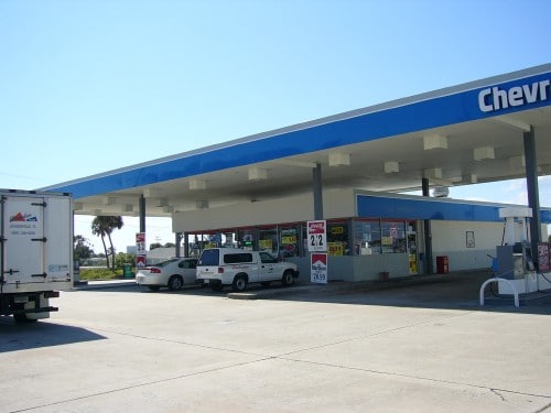
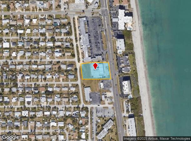
Property Record
256 Highway A1a, Satellite Beach, FL 32937
NEARBY LISTINGS FOR SALE OR LEASE
Property Detail
256 Highway A1a
Palm Bay-Melbourne-Titusville, FL
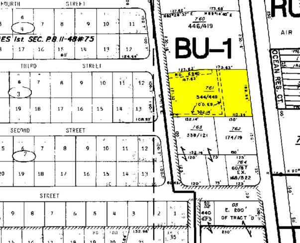
Acreage
26-37-23-00-00761.0-0000.00
PART OF N 1/2 OF LOT 2 LYING W OF A1A AS DES IN ORB 544 PG 448
Servicestationmarket
Brevard
X
Florida
12009C0528H
2
2024
1.30 AC
2025
Brevard County
066900
Orlando
3,200 SF
DEMOGRAPHICS near 256 Highway A1a
1 Mile
3 Mile
5 Mile
2024 Total Population
6,627
18,453
48,316
2029 Population
7,275
20,147
52,764
Pop Growth 2024-2029
+ 9.78%
+ 9.18%
+ 9.21%
Average Age
45
45
46
2024 Total Households
2,936
7,801
21,161
HH Growth 2024-2029
+ 9.50%
+ 8.91%
+ 9.08%
Median Household Inc
$67,885
$87,582
$76,116
Avg Household Size
2.20
2.30
2.20
2024 Avg HH Vehicles
2.00
2.00
2.00
Median Home Value
$318,873
$364,524
$332,767
Median Year Built
1970
1973
1980
Nearby Places
Map Layers
Map Styles
 Street
 Aerial
- Restaurants
- Banks
- Shops
- Fitness
- Groceries
PUBLIC TRANSPORTATION
AIRPORT
Melbourne Orlando International
DRIVE
WALK
Distance
Melbourne Orlando International
27 min
12.2 mi
Freight Ports
Port Canaveral
DRIVE
WALK
Distance
Port Canaveral
28 min
14.4 mi
SALE & LEASE HISTORY
LISTING DATE
SALE/LEASE

Dec 19, 2022
For Sale
Nearby Properties
Address
Land Use
TOTAL SIZE
Lot Size
Zoning
Address
Land Use
TOTAL SIZE
Lot Size
Zoning
1,339.40 AC
Address
Land Use
TOTAL SIZE
Lot Size
Zoning
511,907 SF
75.60 AC
ITU
Address
Land Use
TOTAL SIZE
Lot Size
Zoning
162,759 SF
8.49 AC
RU230
Address
Land Use
TOTAL SIZE
Lot Size
Zoning
90.10 AC
Address
Land Use
TOTAL SIZE
Lot Size
Zoning
94,097 SF
3.21 AC
R2
Address
Land Use
TOTAL SIZE
Lot Size
Zoning
7.02 AC
ITU
Address
Land Use
TOTAL SIZE
Lot Size
Zoning
75,076 SF
3.67 AC
RU215
Address
Land Use
TOTAL SIZE
Lot Size
Zoning
152,762 SF
13.70 AC
C
Address
Land Use
TOTAL SIZE
Lot Size
Zoning
2,792 SF
6.36 AC
ITU
Address
Land Use
TOTAL SIZE
Lot Size
Zoning
72,781 SF
9.54 AC
IN(L)
Address
Land Use
TOTAL SIZE
Lot Size
Zoning
108,296 SF
3.52 AC
Address
Land Use
TOTAL SIZE
Lot Size
Zoning
52,726 SF
12.51 AC
RU111
Address
Land Use
TOTAL SIZE
Lot Size
Zoning
44,045 SF
3.50 AC
TU-1
Address
Land Use
TOTAL SIZE
Lot Size
Zoning
37,948 SF
1.38 AC
RM2
Address
Land Use
TOTAL SIZE
Lot Size
Zoning
26.07 AC
Address
Land Use
TOTAL SIZE
Lot Size
Zoning
Address
Land Use
TOTAL SIZE
Lot Size
Zoning
8.30 AC
ITU
Address
Land Use
TOTAL SIZE
Lot Size
Zoning
52,685 SF
12 AC
ITU
Address
Land Use
TOTAL SIZE
Lot Size
Zoning
65,385 SF
4.74 AC
C
Address
Land Use
TOTAL SIZE
Lot Size
Zoning
12,455 SF
4.87 AC
RU-1-13
Address
Land Use
TOTAL SIZE
Lot Size
Zoning
37,323 SF
3.50 AC
BU-1
Address
Land Use
TOTAL SIZE
Lot Size
Zoning
38,831 SF
4.27 AC
R4
Address
Land Use
TOTAL SIZE
Lot Size
Zoning
52,597 SF
6.61 AC
PUD
Address
Land Use
TOTAL SIZE
Lot Size
Zoning
1.79 AC
ITU
Address
Land Use
TOTAL SIZE
Lot Size
Zoning
0.84 AC
RM3
Address
Land Use
TOTAL SIZE
Lot Size
Zoning
1.89 AC
RM3
Address
Land Use
TOTAL SIZE
Lot Size
Zoning
40,916 SF
3.86 AC
C
Address
Land Use
TOTAL SIZE
Lot Size
Zoning
12,368 SF
2.86 AC
EU
Address
Land Use
TOTAL SIZE
Lot Size
Zoning
16,573 SF
1.95 AC
C
Address
Land Use
TOTAL SIZE
Lot Size
Zoning
0.83 AC
GML
The World's #1 Commercial Real Estate Marketplace
Connect with us
© 2025 CoStar Group
The information above has been obtained from sources believed reliable. While we do not doubt its accuracy we have not verified it and make no guarantee, warranty or representation about it. It is your responsibility to independently confirm its accuracy and completeness. Any projections, opinions, assumptions, or estimates used are for example only and do not represent the current or future performance of the property. The value of this transaction to you depends on tax and other factors which should be evaluated by your tax, financial, and legal advisors. You and your advisors should conduct a careful, independent investigation of the property to determine to your satisfaction the suitability of the property for your needs.